ไฟล์:Philippines location map (square).svg
ไม่รองรับเนื้อหาของหน้าในภาษาอื่น
จากวิกิพีเดีย สารานุกรมเสรี

ดูภาพที่มีความละเอียดสูงกว่า((ไฟล์ SVG, 1,332 × 1,332 พิกเซล, ขนาดไฟล์: 1.49 เมกะไบต์))

Wikimedia Commons logo รูปภาพหรือไฟล์เสียงนี้ ต้นฉบับอยู่ที่ คอมมอนส์ รายละเอียดด้านล่าง เป็นข้อความที่แสดงผลจาก ไฟล์ต้นฉบับในคอมมอนส์
คอมมอนส์เป็นเว็บไซต์ในโครงการสำหรับเก็บรวบรวมสื่อเสรี ที่ คุณสามารถช่วยได้

ความย่อ

https://commons.m.wikimedia.org/wiki/File:VisualEditor_tables_type_inside_a_cell.png

คำอธิบาย
English: Located in Burgos, Ilocos Norte
This is a photo of a cultural heritage property in the Philippines with ID
PH-01-0006
วันที่
แหล่งที่มา งานของตัว
ผู้สร้างสรรค์

[[User:Lumaktaw sa pangunahing content Account Kahapon, 12:53 AMBago

Bagong pag-sign in sa Galaxy A03 larendovaldez0@gmail.com Nasa panganib ang iyong account kung hindi ikaw ito

Galaxy A03 Pilipinas Ang teleponong ito Pamilyar ba sa iyo ang aktibidad na ito? Hindi, i-secure ang account Oo, ako iyon |

Map data ©2024 5 km Devices La Dez 11th Apr 8:16 PM 4HMH+8X San Nicolas, Ilocos Norte, Philippines

]]

Wikimedia Commons

Search File:Cape Bojeador Light House.JPG Language Watch Edit File File history File usage on Commons File usage on other wikis Metadata File:Cape Bojeador Light House.JPG Size of this preview: 800 × 536 pixels. Other resolutions: 320 × 214 pixels | 640 × 429 pixels | 1,024 × 686 pixels | 1,280 × 857 pixels | 2,890 × 1,935 pixels. Original file ‎(2,890 × 1,935 pixels, file size: 5.43 MB, MIME type: image/jpeg); ZoomViewer

File information Structured data Structured data labels link to their respective Wikidata pages and will open in a new window. Items portrayed in this file depicts Search to add items

Custom value Cape Bojeador Lighthouse Mark as prominent creator Search to add items

Custom value some value Mark as prominent Qualifiers object has role photographer

Custom value URL https://commons.wikimedia.org/wiki/User:File:VisualEditor_tables_type_inside_a_cell.png author name string File:VisualEditor_tables_type_inside_a_cell.png Wikimedia username https://commons.m.wikimedia.org/wiki/File:Cape_Bojeador_Light_House.JPG#/editor/1 References

copyright status copyrighted Mark as prominent copyright license Creative Commons Attribution-ShareAlike 3.0 Unported Mark as prominent source of file original creation by uploader Mark as prominent inception 2 April 2010 Mark as prominent captured with Nikon D60 Mark as prominent participant in Wiki Loves Monuments 2012 Mark as prominent MIME type image/jpeg Mark as prominent checksum

คำอธิบาย Wikipedia logo 2.0
วันที่ n/a
แหล่งที่มา Wikimedia Foundation
ผู้สร้างสรรค์ https://commons.m.wikimedia.org/wiki/File:VisualEditor_tables_type_inside_a_cell.png
การอนุญาต
(การใช้ไฟล์นี้ใหม่)
Trademarked
™ มูลนิธิวิกิมีเดีย
ภาพนี้ (หรือบางส่วนของภาพนี้) เป็นหรือประกอบไปด้วยโลโก้ทางการหรือการออกแบบอย่างเป็นทางการที่ใช้ในมูลนิธิวิกิมีเดีย หรือในโครงการต่าง ๆ ของมูลนิธิ การใช้โลโก้และเครื่องหมายการค้าของวิกิมีเดียนั้น เป็นไปตามนโยบายด้านเครื่องหมายการค้า และนโยบายด้านอัตลักษณ์ของมูลนิธิ และอาจต้องขออนุญาตก่อนที่จะนำไปใช้

ป้ายนี้มิใช่ป้ายแสดงสถานะลิขสิทธิ์ ดังนั้นการระบุสถานะลิขสิทธิ์จึงต้องกระทำแยกต่างหาก ดูที่ Commons:Lincensing 

w:th:ครีเอทีฟคอมมอนส์
แสดงที่มา อนุญาตแบบเดียวกัน
การแสดงที่มา: Wikimedia Foundation
คุณสามารถ:
  • ที่จะแบ่งปัน – ที่จะทำสำเนา แจกจ่าย และส่งงานดังกล่าวต่อไป
  • ที่จะเรียบเรียงใหม่ – ที่จะดัดแปลงงานดังกล่าว
ภายใต้เงื่อนไขต่อไปนี้:
  • แสดงที่มา – คุณต้องให้เกียรติเจ้าของงานอย่างเหมาะสม โดยเพิ่มลิงก์ไปยังสัญญาอนุญาต และระบุหากมีการเปลี่ยนแปลง คุณอาจทำเช่นนี้ได้ในรูปแบบใดก็ได้ตามควร แต่ต้องไม่ใช่ในลักษณะที่แนะว่าผู้ให้อนุญาตสนับสนุนคุณหรือการใช้งานของคุณ
  • อนุญาตแบบเดียวกัน – หากคุณดัดแปลง เปลี่ยนรูป หรือต่อเติมงานนี้ คุณต้องใช้สัญญาอนุญาตแบบเดียวกันหรือแบบที่เหมือนกับสัญญาอนุญาตที่ใช้กับงานนี้เท่านั้น

Mark as prominent determination method

SHA-1 data size 5,694,181 byte Mark as prominent height 1,935 pixel Mark as prominent width 2,890 pixel Mark as prominent Wikimedia Commons Files are available under licenses specified on their description page. All structured data from the file namespace is available under the Creative Commons CC0 License; all unstructured text is available under the Creative Commons Attribution-ShareAlike License; additional terms may apply. By using this site, you agree to the Terms of Use and the Privacy Policy. Privacy policy Terms of UseDesktop You are not logged in and your IP address will be publicly visible if you make any edits. Logging in or creating an account will conceal your IP address and provide you with many other benefits. Please do not save test edits. If you want to experiment, please use the Sandbox.

==ความย่อ==
คำอธิบาย
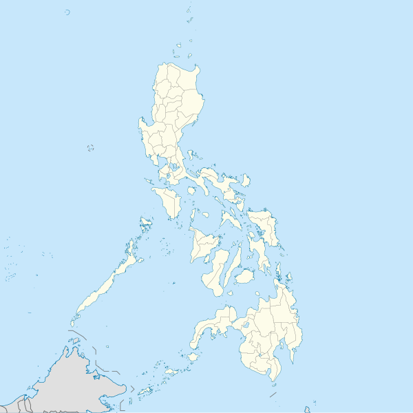
English: Location map of the Philippines

Equirectangular projection based on the parallel of 10°43' N

  • N: 21.2° N
  • S: 4.3° N
  • W: 114.0° E
  • E: 131.2° E
วันที่
แหล่งที่มา

งานของตัว

Author=WikiRoulete
ผู้สร้างสรรค์ Hellerick แก้ไขที่ส่วนข้อมูลมีโครงบนคอมมอนส์

|other fields=SVG genesis

InfoField
 
ซอร์สโค้ดของ SVG นี้ตรวจสอบถูกต้องแล้ว
 
ไฟล์ภาพกราฟิกส์เวกเตอร์นี้ สร้างขึ้นโดยใช้ Inkscape

}}This template has no documented parameters and may be intended for use without them.

การอนุญาตใช้สิทธิ

ข้าพเจ้า ในฐานะผู้ถือลิขสิทธิ์ของภาพหรือสื่อนี้ อนุญาตให้ใช้ภาพหรือสื่อนี้ภายใต้เงื่อนไขต่อไปนี้
w:th:ครีเอทีฟคอมมอนส์
แสดงที่มา อนุญาตแบบเดียวกัน
คุณสามารถ:
  • ที่จะแบ่งปัน – ที่จะทำสำเนา แจกจ่าย และส่งงานดังกล่าวต่อไป
  • ที่จะเรียบเรียงใหม่ – ที่จะดัดแปลงงานดังกล่าว
ภายใต้เงื่อนไขต่อไปนี้:
  • แสดงที่มา – คุณต้องให้เกียรติเจ้าของงานอย่างเหมาะสม โดยเพิ่มลิงก์ไปยังสัญญาอนุญาต และระบุหากมีการเปลี่ยนแปลง คุณอาจทำเช่นนี้ได้ในรูปแบบใดก็ได้ตามควร แต่ต้องไม่ใช่ในลักษณะที่แนะว่าผู้ให้อนุญาตสนับสนุนคุณหรือการใช้งานของคุณ
  • อนุญาตแบบเดียวกัน – หากคุณดัดแปลง เปลี่ยนรูป หรือต่อเติมงานนี้ คุณต้องใช้สัญญาอนุญาตแบบเดียวกันหรือแบบที่เหมือนกับสัญญาอนุญาตที่ใช้กับงานนี้เท่านั้น

คำบรรยายโดยย่อ

เพิ่มคำบรรยายทรรทัดเดียวเพื่อขยายความว่าไฟล์นี้มีอะไร
Map of the Philippines Islands (P.I.)

ไอเทมที่แสดงอยู่ในไฟล์นี้

ประกอบด้วย

media type อังกฤษ

image/svg+xml

ประวัติไฟล์

คลิกวันที่/เวลาเพื่อดูไฟล์ที่ปรากฏในขณะนั้น

(ล่าสุด | เก่าสุด) ดู (ใหม่กว่า 10 | ) (10 | 20 | 50 | 100 | 250 | 500)
วันที่/เวลารูปย่อขนาดผู้ใช้ความเห็น
ปัจจุบัน17:17, 19 สิงหาคม 2564รูปย่อสำหรับรุ่นเมื่อ 17:17, 19 สิงหาคม 25641,332 × 1,332 (1.49 เมกะไบต์)AichiWikiFixerUpdated boundaries
14:53, 18 มิถุนายน 2564รูปย่อสำหรับรุ่นเมื่อ 14:53, 18 มิถุนายน 25641,332 × 1,332 (2.24 เมกะไบต์)AichiWikiFixerMap update.
10:55, 18 มิถุนายน 2564รูปย่อสำหรับรุ่นเมื่อ 10:55, 18 มิถุนายน 25641,332 × 1,332 (2.23 เมกะไบต์)AichiWikiFixerSmall changes.
10:49, 18 มิถุนายน 2564รูปย่อสำหรับรุ่นเมื่อ 10:49, 18 มิถุนายน 25641,332 × 1,332 (2.23 เมกะไบต์)AichiWikiFixerExternal changes for boundaries and coastlines.
20:11, 17 มิถุนายน 2564รูปย่อสำหรับรุ่นเมื่อ 20:11, 17 มิถุนายน 25641,332 × 1,332 (2.23 เมกะไบต์)AichiWikiFixerAdditional islands, lakes, and updated coastlines.
17:34, 17 มิถุนายน 2564รูปย่อสำหรับรุ่นเมื่อ 17:34, 17 มิถุนายน 25641,332 × 1,332 (2.23 เมกะไบต์)AichiWikiFixerUpdate boundaries.
09:04, 25 พฤษภาคม 2564รูปย่อสำหรับรุ่นเมื่อ 09:04, 25 พฤษภาคม 25641,332 × 1,332 (2.22 เมกะไบต์)HueMan1Reverted to version as of 07:24, 7 September 2020 (UTC)
14:11, 17 พฤษภาคม 2564รูปย่อสำหรับรุ่นเมื่อ 14:11, 17 พฤษภาคม 25641,332 × 1,332 (3.72 เมกะไบต์)PetrioloReverted to version as of 05:36, 3 May 2021 (UTC) The new administrative borders are based from the Philippine government websites (https://www.geoportal.gov.ph/; http://noah.up.edu.ph/), and is deemed accurate. These new files have reliable sources and there's no "beauty" in it if it is inaccurate in the first place.
21:00, 16 พฤษภาคม 2564รูปย่อสำหรับรุ่นเมื่อ 21:00, 16 พฤษภาคม 25641,332 × 1,332 (2.22 เมกะไบต์)AichiWikiFixerReverted to version as of 07:24, 7 September 2020 (UTC) (Borders seen as ugly)
12:36, 3 พฤษภาคม 2564รูปย่อสำหรับรุ่นเมื่อ 12:36, 3 พฤษภาคม 25641,332 × 1,332 (3.72 เมกะไบต์)Petrioloupdated with NAMRIA borders
(ล่าสุด | เก่าสุด) ดู (ใหม่กว่า 10 | ) (10 | 20 | 50 | 100 | 250 | 500)

การใช้ไฟล์ข้ามโครงการ

ข้อมูลเกี่ยวกับภาพ