แม่แบบ:กล่องข้อมูล เกาะ
| แม่แบบนี้ใช้ลูอา |
| แม่แบบนี้ใช้ TemplateStyles: |
 ตำแหน่งพิกัด (P625) (ดูเพิ่มที่จำนวนการใช้)
This template is intended to be used as an infobox for an island, islet or an archipelago. For islands or archipelagos which are disputed, use |disputed=yes
Blank infobox[แก้]
{{{local_name}}} สมญา: {{{nickname}}} | |
|---|---|
| [[File:{{{image}}}|{{{image_size}}}|alt={{{image_alt}}}|upright=1.16|{{{image_alt}}}]] {{{image_caption}}} | |
| [[File:{{{image_map}}}|{{{map_size}}}|alt={{{map_alt}}}|upright=1.16|{{{map_alt}}}]] {{{map_caption}}} | |
| ที่มาของชื่อ | {{{etymology}}} |
| ภูมิศาสตร์ | |
| ที่ตั้ง | {{{location}}} |
| พิกัด | 0°N 0°E / 0°N 0°E |
| OS grid reference | 25 |
| ประเภท | {{{island_type}}} |
| กลุ่มเกาะ | {{{archipelago}}} |
| แหล่งน้ำใกล้เคียง | {{{waterbody}}} |
| เกาะทั้งหมด | {{{total_islands}}} |
| เกาะหลัก | {{{major_islands}}} |
| พื้นที่ | {{{area_km2}}} กม.2 ({{{area_sqmi}}} ตารางไมล์){{{area_footnotes}}} |
| อันดับพื้นที่ | {{{rank}}} |
| ความยาว | {{{length_km}}} กม. ({{{length_mi}}} ไมล์){{{length_footnotes}}} |
| ความกว้าง | 123–123 km (76–76 mi){{{width_footnotes}}} |
| ความยาวชายฝั่ง | {{{coastline_km}}} กม. ({{{coastline_mi}}} ไมล์){{{coastline_footnotes}}} |
| ระดับสูงสุด | {{{elevation_m}}} ม. ({{{elevation_ft}}} ฟุต){{{elevation_footnotes}}} |
| จุดสูงสุด | {{{highest_mount}}} |
| การปกครอง | |
{{{country}}} | |
| ปกครองภายใต้{{{treaty_system}}} | |
| {{{country_admin_divisions_title}}} | {{{country_admin_divisions}}} |
| {{{country_admin_divisions_title_1}}} | {{{country_admin_divisions_1}}} |
| {{{country_admin_divisions_title_2}}} | {{{country_admin_divisions_2}}} |
| {{{country_admin_divisions_title_3}}} | {{{country_admin_divisions_3}}} |
| {{{country_admin_divisions_title_4}}} | {{{country_admin_divisions_4}}} |
| {{{country_largest_city_type}}}หลวงและ{{{country_largest_city_type}}}ใหญ่สุด | {{{country_capital_and_largest_city}}} (ประชากร {{{country_largest_city_population}}} คน) |
| {{{country_leader_title}}} | {{{country_leader_name}}} |
| พื้นที่ | {{{country_area_km2}}} กม.2 ({{{country_area_sqmi}}} ตารางไมล์){{{country_area}}} |
{{{country1}}} | |
| {{{country1_admin_divisions_title}}} | {{{country1_admin_divisions}}} |
| {{{country1_admin_divisions_title_1}}} | {{{country1_admin_divisions_1}}} |
| {{{country1_largest_city_type}}}หลวงและ{{{country1_largest_city_type}}}ใหญ่สุด | {{{country1_capital_and_largest_city}}} (pop. {{{country1_largest_city_population}}}) |
| {{{country1_leader_title}}} | {{{country1_leader_name}}} |
| พื้นที่ | {{{country1_area_km2}}} กม.2 ({{{country1_area_sqmi}}} ตารางไมล์){{{country1_area}}} |
{{{country8}}} | |
| {{{country8_admin_divisions_title}}} | {{{country8_admin_divisions}}} |
| {{{country8_admin_divisions_title_1}}} | {{{country8_admin_divisions_1}}} |
| {{{country8_leader_title}}} | {{{country8_leader_name}}} |
| พื้นที่ | {{{country8_area_km2}}} กม.2 ({{{country8_area_sqmi}}} ตารางไมล์){{{country8_area}}} |
| ประชากรศาสตร์ | |
| เดมะนิม | {{{demonym}}} |
| ประชากร | {{{population}}} ({{{population_as_of}}}){{{population_footnotes}}} |
| อันดับประชากร | {{{population_rank}}} จาก {{{population_rank_max}}} |
| ความหนาแน่น | {{{density_km2}}}/กม.2 ({{{density_sqmi}}}/ตารางไมล์){{{density_footnotes}}} |
| อันดับความหนาแน่น | {{{density_rank}}} |
| ภาษา | {{{languages}}} |
| กลุ่มชาติพันธุ์ | {{{ethnic_groups}}} |
| ข้อมูลอื่น ๆ | |
| เขตเวลา |
|
| • ฤดูร้อน (ออมแสง) |
|
| {{{postal_code_type}}} | {{{postal_code}}} |
| {{{area_code_type}}} | {{{area_code}}} |
| ทะเบียนรถ | {{{registration_plate}}} |
| {{{iso_code_type}}} | {{{iso_code}}} |
| เว็บไซต์ทางการ | {{{website}}} |
| {{{additional_info}}} | |
| {{{misc}}} {{{module}}} | |
| {{{footnotes}}} | |
Metric units[แก้]
{{Infobox islands
| name                              = {{subst:PAGENAME}}
| native_name                       = <!-- or |local_name= -->
| native_name_link                  =
| native_name_lang                  =
| sobriquet                         = <!-- or |nickname= -->
| image_name                        =
| image_size                        =
| image_caption                     =
| image_alt                         =
| image_map                         =
| image_map_alt                     =
| image_map_size                    =
| image_map_caption                 =
| pushpin_map                       =
| pushpin_label                     =
| pushpin_label_position            =
| pushpin_map_alt                   =
| pushpin_relief                    =
| pushpin_map_caption               =
| coordinates                       = <!-- {{coord|display=it}} -->
| etymology                         =
| location                          = <!-- mandatory, body of water where located -->
| grid_reference                    = <!-- UK only -->
| archipelago                       =
| waterbody                         =
| total_islands                     =
| major_islands                     =
| area_km2                          = <!-- or |area_m2= or |area_ha= -->
| area_footnotes                    =
| rank                              =
| length_km                         = <!-- or |length_m=  -->
| length_footnotes                  =
| width_km                          = <!-- or |width_m=  -->
| width_footnotes                   =
| coastline_km                      = <!-- or |coastline_m=  -->
| coastline_footnotes               =
| elevation_m                       =
| elevation_footnotes               =
| highest_mount                     =
| country                           = <!-- mandatory -->
| country_admin_divisions_title     =
| country_admin_divisions           =
| country_admin_divisions_title_1   =
| country_admin_divisions_1         =
| country_admin_divisions_title_2   =
| country_admin_divisions_2         =
| country_capital_type              =
| country_capital                   =
| country_largest_city_type         =
| country_largest_city              =
| country_capital_and_largest_city  =
| country_largest_city_population   =
| country_leader_title              =
| country_leader_name               =
| country_area_km2                  = <!-- or |country_area_m2= or |country_area_ha= -->
| country1                          =
| country1_admin_divisions_title    =
| country1_admin_divisions          =
| country1_admin_divisions_title_1  =
| country1_admin_divisions_1        =
| country1_capital_type             =
| country1_capital                  =
| country1_largest_city_type        =
| country1_largest_city             =
| country1_capital_and_largest_city =
| country1_largest_city_population  =
| country1_leader_title             =
| country1_leader_name              =
| country1_area_km2                 = <!-- or |country1_area_m2= or |country1_area_ha= -->
| demonym                           =
| population                        =
| population_as_of                  =
| population_footnotes              =
| population_rank =
| population_rank_max               =
| density_km2                       =
| density_rank =
| density_footnotes                 =
| languages                         =
| ethnic_groups                     =
| timezone1                         =
| utc_offset1                       =
| timezone1_DST                     =
| utc_offset1_DST                   =
| website                           =
| additional_info                   =
| footnotes                         =
}}
Non-metric units[แก้]
{{Infobox islands
| name                              = <!-- mandatory -->
| native_name                       = <!-- or |local_name= -->
| native_name_link                  =
| native_name_lang                  =
| sobriquet                         = <!-- or |nickname= -->
| image                             =
| image_size                        =
| image_caption                     =
| image_alt                         =
| image_map                         =
| image_map_alt                     =
| image_map_size                    =
| image_map_caption                 =
| pushpin_map                       =
| pushpin_label                     =
| pushpin_label_position            =
| pushpin_map_alt                   =
| pushpin_relief                    =
| pushpin_map_caption               =
| coordinates                       = <!-- {{coord|LATITUDE|N/S|LONGITUDE|E/W|display=it}} -->
| etymology                         =
| location                          = <!-- mandatory, body of water where located -->
| grid_reference                    = <!-- UK only -->
| archipelago                       =
| waterbody                         =
| total_islands                     =
| major_islands                     =
| area_sqmi                         = <!-- or |area_sqft= or |area_acre= -->
| area_footnotes                    =
| rank                              =
| length_mi                         = <!-- or |length_ft= -->
| length_footnotes                  =
| width_mi                          = <!-- or |width_ft= -->
| width_footnotes                   =
| coastline_mi                      = <!-- or |coastline_ft= -->
| coastline_footnotes               =
| elevation_ft                      =
| elevation_footnotes               =
| highest_mount                     =
| country                           = <!-- mandatory -->
| country_admin_divisions_title     =
| country_admin_divisions           =
| country_admin_divisions_title_1   =
| country_admin_divisions_1         =
| country_admin_divisions_title_2   =
| country_admin_divisions_2         =
| country_capital_type              =
| country_capital                   =
| country_largest_city_type         =
| country_largest_city              =
| country_capital_and_largest_city  =
| country_largest_city_population   =
| country_leader_title              =
| country_leader_name               =
| country_area_sqmi                 = <!-- or |country_area_sqft= or |country_area_acre= -->
| country1                          =
| country1_admin_divisions_title    =
| country1_admin_divisions          =
| country1_admin_divisions_title_1  =
| country1_admin_divisions_1        =
| country1_capital_type             =
| country1_capital                  =
| country1_largest_city_type        =
| country1_largest_city             =
| country1_capital_and_largest_city =
| country1_largest_city_population  =
| country1_leader_title             =
| country1_leader_name              =
| country1_area_sqmi                = <!-- or |country1_area_sqft= or |country1_area_acre= -->
| demonym                           =
| population                        =
| population_as_of                  =
| population_footnotes              =
| population_rank =
| population_rank_max               =
| density_sqmi                      =
| density_rank =
| density_footnotes                 =
| ethnic_groups                     =
| timezone1                         =
| utc_offset1                       =
| timezone1_DST                     =
| utc_offset1_DST                   =
| website                           =
| additional_info                   =
| footnotes                         =
}}
Width range[แก้]
To express a width range, replace |width_km= or |width_m= or |width_mi= or |width_ft= with one of the following:
| width_min_km     =
| width_max_km     =
or
| width_min_m      =
| width_max_m      =
or
| width_min_mi     =
| width_max_mi     =
or
| width_min_ft     =
| width_max_ft     =
Parameters[แก้]
Mandatory[แก้]
- name = the official name (without the word island)
- location = the sea in which the island is located
- country = where the island is located. Either specify the standard three-letter ISO 3166-1 alpha-3 code for the country, or a name by which the country is commonly known (e.g., "US", "South Korea", "Democratic People's Republic of Korea"). If the island is shared, then use "country 1" and "country 2" and list them alphabetically.
Optional[แก้]
- native_name = only when the common name is different from the native name. To remove the "native name" prefix, use local_name instead.
- native_name_link = link to the article about the language used for the native name.
- sobriquet (or nickname) = for a well-known sobriquet or nickname
- image = locator/satellite/other map image (without the prefix "File:" or "Image:")
- image_caption = caption for the image
- image_size = size of the image in pixels (e.g., "100px")
- image_alt = alt text for readers who cannot see the image; see Wikipedia:Alternative text for images for more information
- image_map = locator/satellite/other map image (without the prefix "File:" or "Image:")
- image_map_caption = caption for the image
- image_map_size = size of the image in pixels (e.g., "100px")
- image_map_alt = alt text for readers who cannot see the image; see Wikipedia:Alternative text for images for more information
- pushpin_map = the name of a location map as per Template:Location map (e.g. Indonesia or Russia)
- pushpin_map_alt = alt text for the map, primarily for visually impaired readers
- pushpin_map_caption = a map caption if desired
- pushpin_relief = whether to use a relief map if one is available
- pushpin_map_width = the width of the map
- coordinates = coordinates in the {{Coord}} format (
type:isleis added by default, unless anothertypeis specified) - Grid_Reference = Ordnance survey grid ref (UK only)
- archipelago = the name of the group of islands the island belongs to
- total_islands = total number of islands (for archipelagos only)
- major_islands = names of the major islands (for archipelagos only)
- area_km2 or area_sqmi or area_m2 or area_sqft or area_acre or area_ha = the area in either square kilometres or square miles or square metres or square feet or hectares or acres without using {{convert}}; the conversion will be done automatically
- area_footnotes = references for area values using
<ref>...</ref>format.
- area_footnotes = references for area values using
- rank = the island's rank among other islands in the world in terms of size (1st being the largest island), as indicated in "List of islands by area"
- length_km or length_mi or length_m or length_ft = the length in either kilometres or miles or metres or feet without using {{convert}}; the conversion will be done automatically
- length_footnotes = references for length values using
<ref>...</ref>format.
- length_footnotes = references for length values using
- width_km or width_mi or width_m or width_ft = the width in either kilometres or miles or metres or feet without using {{convert}}; the conversion will be done automatically
- width_footnotes = references for width values using
<ref>...</ref>format.
- width_footnotes = references for width values using
- coastline_km or coastline_mi or coastline_m or coastline_ft = the length of the coastline in either kilometres or miles or metres or feet without using {{convert}}; the conversion will be done automatically
- coastline_footnotes = references for coastline values using
<ref>...</ref>format.
- coastline_footnotes = references for coastline values using
- elevation_m or elevation_ft = the height of the highest point in either metres or feet without using {{convert}}; the conversion will be done automatically
- elevation_footnotes = references for elevation values using
<ref>...</ref>format.
- elevation_footnotes = references for elevation values using
- highest_mount = name of the highest point on the island, if any
- country_admin_divisions_title = title for the administrative divisions
- country_admin_divisions = the administrative divisions that govern the island
- country_admin_divisions_title_1 = (country admin_divisions title 1)
- country_admin_divisions_1 = (country admin divisions 1)
- country_admin_divisions_title_2 = (country admin divisions title 2)
- country_admin_divisions_2 = (country admin divisions 2)
- country_capital_type = the capital's type of settlement (default value is "city")
- country_capital
- country_largest_city_type = the largest city's type of settlement (default value is "settlement")
- country_largest_city
- country_capital_and_largest_city
- country_largest_city_population
- country_leader_title
- country_leader_name
- country_area_km2 or country_area_sqmi or country_area_m2 or country_area_sqft or country_area_acre or country_area_ha = the area in either square kilometres or square miles or square metres or square feet or hectares or acres without using {{convert}}; the conversion will be done automatically
- country1 = (see country)
- country1_admin_divisions_title = (country_admin_divisions_title)
- country1_admin_divisions = (country_admin_divisions)
- country1_capital_type = (country_capital_type)
- country1_capital = (country_capital)
- country1_largest_city type = (country_largest_city_type)
- country1_largest_city = (country_largest_city)
- country1_capital_and_largest_city = (country_capital_and_largest_city)
- country1_largest_city_population = (country_largest_city_population)
- country1_leader_title
- country1_leader_name
- country1_area_km2 or country1_area_sqmi or country1_area_m2 or country1_area_sqft or country1_area_acre or country1_area_ha = the area in either square kilometres or square miles or square metres or square feet or hectares or acres without using {{convert}}; the conversion will be done automatically
- country2 = (see country)
- country2_admin_divisions_title = (country_admin_divisions_title)
- country2_admin_divisions = (country_admin_divisions)
- country2_capital_type = (country_capital_type)
- country2_capital = (country_capital)
- country2_largest_city_type = (country_largest_city_type)
- country2_largest_city = (country_largest_city)
- country2_capital_and_largest_city = (country_capital_and_largest_city)
- country2_largest_city_population = (country_largest_city_population)
- country2_leader_title
- country2_leader_name
- country2_area_km2 or country2_area_sqmi or country2_area_m2 or country2_area_sqft or country2_area_acre or country2_area_ha = the area in either square kilometres or square miles or square metres or square feet or hectares or acres without using {{convert}}; the conversion will be done automatically
- ...
- country8 = (see country)
- country8_admin_divisions_title = (country_admin_divisions_title)
- country8_admin_divisions = (country_admin_divisions)
- country8_capital_type = (country_capital_type)
- country8_capital = (country_capital)
- country8_largest_city_type = (country_largest_city_type)
- country8_largest_city = (country_largest_city)
- country8_capital_and_largest_city = (country_capital_and_largest_city)
- country8_largest_city_population = (country_largest_city_population)
- country8_leader_title
- country8_leader_name
- country8_area_km2 or country8_area_sqmi or country8_area_m2 or country8_area_sqft or country8_area_acre or country8_area_ha = the area in either square kilometres or square miles or square metres or square feet or hectares or acres without using {{convert}}; the conversion will be done automatically
- demonym = the name the people of the island are called that is based on location
- population = the size of the island's population
- population_as_of = the year when the population census took place
- population_footnotes = references for population values using
<ref>...</ref>format.
- population_footnotes = references for population values using
- density_km2 or density_sqmi = the population density of the island expressed in either persons per square kilometres or persons per square miles without using {{convert}}; the conversion will be done automatically. For example, if the number is 85, the output for
density km2is 85/km2 (220/sq mi).- density_footnotes = references for density values using
<ref>...</ref>format.
- density_footnotes = references for density values using
- languages = list of native languages spoken by the island's population
- ethnic_groups = list the major ethnic groups making up the island's population
- timezone1 =
- utc_offset1 =
- timezone1_DST =
- utc_offset1_DST =
- timezone2 =
- utc_offset2 =
- timezone2_DST =
- utc_offset2_DST =
- website =
- additional_info = a space for additional information at the bottom of the infobox
- footnotes =
Location maps[แก้]
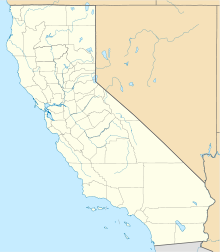
The map parameter can be used to display a map with a location marker.
| ภูมิศาสตร์ | |
|---|---|
| ที่ตั้ง | Pacific Ocean |
| พิกัด | 33°23′0″N 118°25′0″W / 33.38333°N 118.41667°W |
| การปกครอง | |
United States | |
{{Infobox islands
| name              = Santa Catalina Island
| pushpin_map       = USA California
| pushpin_map_width = 220
| coordinates       = {{coord|33|23|0|N|118|25|0|W|display=inline}}
| location          = [[Pacific Ocean]]
| country           = United States
}}
The pushpin_map_caption parameter can be used to display a caption below the map. A width of 220px is generally recommended but this width should be reduced for maps that are taller than they are wide. Use pushpin_map_width=220 and not pushpin_map_width=220px.
Disputed territory[แก้]
If the territory in question is disputed, use |disputed=yes, which will add an additional header to show which other countries are making a claim.
| กรณีพิพาทเกาะ | |
|---|---|
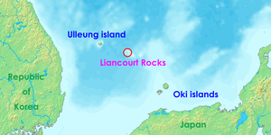
 Location of the Liancourt Rocks in the Sea of Japan (East Sea) between South Korea and Japan | |
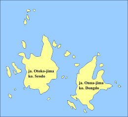
 Liancourt Rocks | |
| ชื่ออื่น | Dokdo, Takeshima |
| ภูมิศาสตร์ | |
| ที่ตั้ง | Sea of Japan (East Sea) |
| พิกัด | 37°14′30″N 131°52′0″E / 37.24167°N 131.86667°E |
| เกาะทั้งหมด | 90 (37 permanent land) |
| เกาะหลัก | East Islet, West Islet |
| การปกครอง | |
South Korea | |
| County | Ulleung County |
| อ้างสิทธิ์โดย | |
Japan | |
| Town | Okinoshima |
South Korea | |
| County | Ulleung County |
| ประชากรศาสตร์ | |
| ประชากร | 2 + 43 support personnel |
| กลุ่มชาติพันธุ์ | Korean |
{{Infobox islands
| disputed                   = yes
| name                       = Liancourt Rocks
| plural                     = yes
| other_names                = Dokdo, Takeshima
| image_name                 = Location-of-Liancourt-rocks-en.png
| image_size                 = 300px
| image_caption              = Location of the Liancourt Rocks in the Sea of Japan (East Sea) between South Korea and Japan
| image_map                  = Liancourt Rocks Map.svg
| map_caption                = Liancourt Rocks
| location                   = [[Sea of Japan]] (East Sea)
| coordinates                = {{coord|37|14|30|N|131|52|0|E|display=inline}}
| total_islands              = 90 (37 permanent land)
| major_islands              = East Islet, West Islet
| country                    = South Korea
| country_admin_divisions_title = County
| country_admin_divisions    = [[Ulleung County]]
| country1                   = Japan
| country1_admin_divisions_title = Town
| country1_admin_divisions   = [[Okinoshima, Shimane|Okinoshima]]
| country2                   = South Korea
| country2_admin_divisions_title = County
| country2_admin_divisions   = [[Ulleung County]]
| population                 = 2 + 43 support personnel
| ethnic_groups              = [[Korean people|Korean]]
}}
Microformat[แก้]
This template generates an hCard microformat. More information can be found here.
หมวดหมู่ติดตาม[แก้]
- หมวดหมู่:บทความที่ใช้กล่องข้อมูลเกาะที่มีข้อมูลเพิ่มเติม (4)
- หมวดหมู่:หน้าที่ใช้กล่องข้อมูลเกาะที่มีพารามิเตอร์ที่ไม่รู้จัก (189)
- หมวดหมู่:หน้าที่ใช้กล่องข้อมูลเกาะที่มีพารามิเตอร์ขัดแย้งกัน (0)
ดูเพิ่ม[แก้]
- แม่แบบสนับสนุน
| คู่มือการใช้งานที่ปรากฏด้านบนนี้ดึงมาจาก แม่แบบ:กล่องข้อมูล เกาะ/doc (แก้ | ประวัติ) ผู้เขียนสามารถทำการทดลองได้ที่กระบะทราย (สร้าง | คัดลอก) และชุดทดสอบ (สร้าง) ของแม่แบบนี้ โปรดเพิ่มหมวดหมู่ไปที่หน้าย่อย /doc หน้าย่อยของแม่แบบนี้ |


