วาน
หน้าตา
วาน Van | |
|---|---|
|
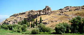
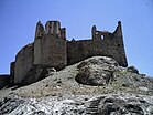
จากบนลงล่าง: ป้อมวาน, ปราสาทโฮชาพ, อาสนวิหารแห่งกางเขนศักดิ์สิทธิ์, ทะเลสาบวาน, ทุชบา, ถนนอิสเคเล, น้ำตกมูราดีเย | |
| พิกัด: 38°29′39″N 43°22′48″E / 38.49417°N 43.38000°E | |
| ประเทศ | ตุรกี |
| ภูมิภาค | อานาโตเลียตะวันออก |
| จังหวัด | วาน |
| การปกครอง | |
| • นายกเทศมนตรี | Bedia Özgökçe Ertan (ได้รับการเลือกตั้ง, ถูกจำคุก) Mehmet Emin Bilmez (แต่งตั้งโดยรัฐ) |
| พื้นที่[1] | |
| • อำเภอกลาง | 1,938.14 ตร.กม. (748.32 ตร.ไมล์) |
| ความสูง | 1,726 เมตร (5,663 ฟุต) |
| ประชากร (2012)[2] | |
| • เขตเมือง | 370,190 คน |
| • อำเภอกลาง | 472,069 |
| • ความหนาแน่นอำเภอกลาง | 240 คน/ตร.กม. (630 คน/ตร.ไมล์) |
วาน (ตุรกี: Van; อาร์มีเนีย: Վան; เคิร์ด: Wan[3]) เป็นเมืองที่เคยมีประชากรส่วนใหญ่เป็นชาวอาร์มีเนีย[4][5][6]ทางตะวันออกเฉียงใต้ของจังหวัดวาน ประเทศตุรกี ตั้งอยู่บนฝั่งตะวันออกของทะเลสาบวาน ปัจจุบันมีประชากรส่วนใหญ่เป็นชาวเคิร์ด[7][8] เมืองส่งหนังสัตว์ ผลไม้ และธัญพืชออกจำหน่าย
วานมักได้รับการกล่าวถึงในเรื่องอาร์มีเนียตะวันตกและเคอร์ดิสถานตอนเหนือ[9][10]
ประชากร
[แก้]ใน ค.ศ. 2010 วานมีประชากรอย่างเป็นทางการที่ 367,419 คน[11] แต่ใน ค.ศ. 1996 มีการประมาณการสูงกว่าที่ 500,000 คน[12] และอดีตนายกเทศมนตรี Burhan Yengun กล่าวว่าเมืองนี้อาจมีประชากรสูงถึง 600,000 คน[13] อำเภอกลางวานกินพื้ที่มากกว่า 2,289 ตารางกิโลเมตร (884 ตารางไมล์)[14] ปัจจุบัน วานมีประชากรส่วนใหญ่เป็นชาวเคิร์ดและประชากรส่วนน้อยเป็นชาวตุรกี[15]
ภูมิศาสตร์
[แก้]ภูมิอากาศ
[แก้]| ข้อมูลภูมิอากาศของวาน (ค.ศ. 1991–2020, สูงสุด ค.ศ. 1939–2020) | |||||||||||||
|---|---|---|---|---|---|---|---|---|---|---|---|---|---|
| เดือน | ม.ค. | ก.พ. | มี.ค. | เม.ย. | พ.ค. | มิ.ย. | ก.ค. | ส.ค. | ก.ย. | ต.ค. | พ.ย. | ธ.ค. | ทั้งปี |
| อุณหภูมิสูงสุดที่เคยบันทึก °C (°F) | 12.6 (54.7) |
14.3 (57.7) |
22.7 (72.9) |
27.2 (81) |
28.3 (82.9) |
33.5 (92.3) |
37.5 (99.5) |
36.7 (98.1) |
35.0 (95) |
28.8 (83.8) |
20.1 (68.2) |
15.5 (59.9) |
37.5 (99.5) |
| อุณหภูมิสูงสุดเฉลี่ย °C (°F) | 2.9 (37.2) |
3.5 (38.3) |
7.5 (45.5) |
13.2 (55.8) |
18.6 (65.5) |
24.3 (75.7) |
28.3 (82.9) |
28.8 (83.8) |
24.4 (75.9) |
17.8 (64) |
10.3 (50.5) |
5.2 (41.4) |
15.4 (59.7) |
| อุณหภูมิเฉลี่ยแต่ละวัน °C (°F) | −2.1 (28.2) |
−1.2 (29.8) |
2.9 (37.2) |
8.4 (47.1) |
13.4 (56.1) |
18.8 (65.8) |
22.7 (72.9) |
22.9 (73.2) |
18.4 (65.1) |
12.1 (53.8) |
5.2 (41.4) |
0.2 (32.4) |
10.1 (50.2) |
| อุณหภูมิต่ำสุดเฉลี่ย °C (°F) | −6.0 (21) |
−5.2 (22.6) |
−1.2 (29.8) |
3.6 (38.5) |
8.0 (46.4) |
12.3 (54.1) |
16.0 (60.8) |
16.2 (61.2) |
12.0 (53.6) |
6.8 (44.2) |
0.9 (33.6) |
−3.6 (25.5) |
5.0 (41) |
| อุณหภูมิต่ำสุดที่เคยบันทึก °C (°F) | −28.7 (-19.7) |
−28.2 (-18.8) |
−22.7 (-8.9) |
−13.1 (8.4) |
−3.5 (25.7) |
−2.6 (27.3) |
3.6 (38.5) |
5.0 (41) |
−0.1 (31.8) |
−14.0 (7) |
−18.6 (-1.5) |
−21.3 (-6.3) |
−28.7 (−19.7) |
| หยาดน้ำฟ้า มม (นิ้ว) | 32.9 (1.295) |
35.4 (1.394) |
49.0 (1.929) |
57.2 (2.252) |
45.8 (1.803) |
16.6 (0.654) |
7.9 (0.311) |
5.6 (0.22) |
19.9 (0.783) |
45.9 (1.807) |
48.8 (1.921) |
45.2 (1.78) |
410.2 (16.15) |
| วันที่มีหยาดน้ำฟ้าโดยเฉลี่ย | 8.07 | 9.47 | 11.30 | 12.60 | 11.10 | 4.93 | 2.17 | 1.57 | 2.93 | 8.47 | 8.07 | 9.83 | 90.5 |
| จำนวนชั่วโมงที่มีแดด | 155.0 | 161.0 | 201.5 | 231.0 | 294.5 | 351.0 | 372.0 | 347.2 | 306.0 | 232.5 | 177.0 | 127.1 | 2,955.8 |
| แหล่งที่มา: Turkish State Meteorological Service[16] | |||||||||||||
แลนด์มาร์ก
[แก้]ส่วนนี้รอเพิ่มเติมข้อมูล คุณสามารถช่วยเพิ่มข้อมูลส่วนนี้ได้ |
ความสัมพันธ์กับนานาชาติ
[แก้]เมืองพี่น้อง
[แก้]วานเป็นเมืองพี่น้องกับเมืองดังนี้:
 บูร์ซา ประเทศตุรกี[17]
 ออแดซา ประเทศยูเครน
ภาพ
[แก้]-
ที่ตั้งของอดีตเมืองวานใน ค.ศ. 2009
-
ที่ตั้งของอดีตเมืองวานใน ค.ศ. 2009
-
ที่ตั้งของอดีตเมืองวานใน ค.ศ. 2009
-
เมืองวานมองจากปราสาทวาน
อ้างอิง
[แก้]- ↑ "Area of regions (including lakes), km²". Regional Statistics Database. Turkish Statistical Institute. 2002. สืบค้นเมื่อ 2013-03-05.
- ↑ "Population of province/district centers and towns/villages by districts - 2012". Address Based Population Registration System (ABPRS) Database. Turkish Statistical Institute. สืบค้นเมื่อ 2013-02-27.
- ↑ "Lawmaker proposes changing name of eastern Van province to 'Wan' - Turkey News". Hürriyet Daily News (ภาษาอังกฤษ). สืบค้นเมื่อ 2019-12-17.
- ↑ Values as printed in the official statistics from 1914.
- ↑ Minassian, 181.
- ↑ Akcam, Taner. A Shameful Act, p. 140. New York:Henry Holt Co. 2006. ISBN 0-8050-8665-X
- ↑ "Justin McCarthy. <italic>Muslims and Minorities: The Population of Ottoman Anatolia and the End of the Empire</italic>. New York: New York University Press; distributed by Columbia University Press, New York. 1983. Pp. xii, 248. $35.00". The American Historical Review. February 1985. doi:10.1086/ahr/90.1.191-a. ISSN 1937-5239.
- ↑ Özoğglu, Hakan (1996-05-01). "State‐tribe relations: Kurdish tribalism in the 16th‐ and 17th‐century Ottoman empire". British Journal of Middle Eastern Studies. 23 (1): 5–27. doi:10.1080/13530199608705620. ISSN 1353-0194.
- ↑ Bois, Th; Minorsky, V.; MacKenzie, D. N. (24 April 2012). "KURDS, KURDISTAN". Encyclopaedia of Islam, Second Edition. doi:10.1163/1573-3912_islam_com_0544. สืบค้นเมื่อ 2021-04-02.
- ↑ "The Council of the Society for the Promotion of Roman Studies". Journal of Roman Studies. 1: 272–284. November 1911. doi:10.1017/s0075435800066946. ISSN 0075-4358.
- ↑ "Archived copy". คลังข้อมูลเก่าเก็บจากแหล่งเดิมเมื่อ 2011-10-04. สืบค้นเมื่อ 2010-02-16.
{{cite web}}: CS1 maint: archived copy as title (ลิงก์) - ↑ David McDowall, "Modern History of the Kurds," I.B. Tauris, 1996, pg 440
- ↑ TESEV. "An Assessment of the Van Action Plan for the Internally Displaced" Accessed at http://www.tesev.org.tr/UD_OBJS/PDF/DEMP/TESEV_VanActionPlanReport.pdf เก็บถาวร 2010-10-11 ที่ เวย์แบ็กแมชชีน
- ↑ http://www.sanalda1numara.net/dogu-anadolu-bolgesi/166142-van-ili-tarihcesi-yuzolcumu-nufus-ve-sosyal-yapi-ilceleri.html เก็บถาวร 2011-11-22 ที่ เวย์แบ็กแมชชีน Van Central district (sanalda1numara.net)
- ↑ Özoğlu, Hakan (May 1996). "State–Tribe Relations: Kurdish Tribalism in the 16th-and 17th-Century Ottoman Empire". British Journal of Middle Eastern Studies. Taylor & Francis. 23 (1): 5–27. doi:10.1080/13530199608705620.
- ↑ "Resmi İstatistikler: İllerimize Ait Mevism Normalleri (1991–2020)" (ภาษาตุรกี). Turkish State Meteorological Service. สืบค้นเมื่อ 2 May 2021.
- ↑ "Kardeş Şehirler". Bursa Büyükşehir Belediyesi Basın Koordinasyon Merkez. Tüm Hakları Saklıdır. คลังข้อมูลเก่าเก็บจากแหล่งเดิมเมื่อ 23 May 2016. สืบค้นเมื่อ 2013-07-27.
บรรณานุกรม
[แก้]แหล่งข้อมูลอื่น
[แก้]วิกิมีเดียคอมมอนส์มีสื่อที่เกี่ยวข้องกับ วาน
วิกิท่องเที่ยว มีคำแนะนำการท่องเที่ยวสำหรับ Van


