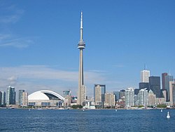
โทรอนโต
(เปลี่ยนทางจาก Toronto)
บทความนี้อาจต้องการตรวจสอบต้นฉบับ ในด้านไวยากรณ์ รูปแบบการเขียน การเรียบเรียง คุณภาพ หรือการสะกด คุณสามารถช่วยพัฒนาบทความได้ |
โทรอนโต Toronto | |
|---|---|
นคร | |
| City of Toronto นครโทรอนโต | |
 | |
|
| |
| สมญา: | |
| คำขวัญ: Diversity Our Strength | |
 Location of Toronto and its census metropolitan area in the province of Ontario | |
| พิกัด: 43°42′59.72″N 79°20′26.47″W / 43.7165889°N 79.3406861°W | |
| Country | |
| Province | แม่แบบ:ON |
| Former cities | East York, Etobicoke, North York, Old Toronto, Scarborough, York |
| Settled | 1750 (as Fort Rouillé) |
| Established | August 27, 1793 (as York) |
| Incorporated | March 6, 1834 (as Toronto) |
| Amalgamated | January 1, 1998 (from Metropolitan Toronto) |
| การปกครอง | |
| • Mayor | John Tory |
| • Council | Toronto City Council |
| • MPs | List of MPs |
| • MPPs | List of MPPs |
| พื้นที่[1] | |
| • นคร | 630 ตร.กม. (240 ตร.ไมล์) |
| • เขตเมือง | 1,749 ตร.กม. (675 ตร.ไมล์) |
| • รวมปริมณฑล | 7,125 ตร.กม. (2,751 ตร.ไมล์) |
| ความสูง | 76 เมตร (249 ฟุต) |
| ประชากร (2006)[1] | |
| • นคร | 2,503,281 (1st) คน |
| • ความหนาแน่น | 3,972 คน/ตร.กม. (10,290 คน/ตร.ไมล์) |
| • เขตเมือง | 4,753,120 (1st) คน |
| • รวมปริมณฑล | 5,113,149 (1st) คน |
| • Demonym | Torontonian |
| เขตเวลา | UTC-5 (EST) |
| • ฤดูร้อน (เวลาออมแสง) | UTC-4 (EDT) |
| Postal code span | M |
| รหัสพื้นที่ | (416) and (647) |
| NTS Map | 030M11 |
| GNBC Code | FEUZB |
| เว็บไซต์ | www.toronto.ca |

โทรอนโต (อังกฤษ: Toronto) เป็นเมืองที่ใหญ่ที่สุดในประเทศแคนาดา และเป็นเมืองที่ใหญ่อันดับที่ 4 ในทวีปอเมริกาเหนือ และโทรอนโตเป็นเมืองที่ใหญ่ที่สุดของรัฐออนแทรีโอ ของแคนาดา โทรอนโตมีประชากรประมาณ 5,555,912 คน (ข้อมูลคาดการณ์ ในปี พ.ศ. 2549)[2] โทรอนโตได้ชื่อว่าเป็นเมืองที่มีหลายเชื้อชาติมากที่สุดเมืองหนึ่ง และโทรอนโตเป็นศูนย์กลางทางด้านเศรษฐกิจ ศิลปะ วัฒนธรรมของประเทศแคนาดา โดยในปี พ.ศ. 2548 รัฐบาลแคนาดาได้จัดให้โทรอนโตเป็นเมืองหลวงวัฒนธรรมของประเทศ
อ้างอิง[แก้]
- ↑ 1.0 1.1 "Population and dwelling counts, for urban areas, 2006 and 2001 censuses - 100% data". Statistics Canada, 2006 Census of Population. 2007-03-13. คลังข้อมูลเก่าเก็บจากแหล่งเดิมเมื่อ 2019-01-06. สืบค้นเมื่อ 2007-03-19.
- ↑ The fact that these municipalities form the GTA is stated in "Ontario Population Projections Update, 2005–2031 Ontario and Its 49 Census Divisions". Ministry of Finance, Government of Ontario. 2006. คลังข้อมูลเก่าเก็บจากแหล่งเดิมเมื่อ 2007-06-13. สืบค้นเมื่อ 2007-03-18.
The Greater Toronto Area (GTA), comprising the City of Toronto and the regional municipalities of Durham, Halton, Peel and York, ...
{{cite web}}: ไม่รู้จักพารามิเตอร์|month=ถูกละเว้น (help)
แหล่งข้อมูลอื่น[แก้]
 คู่มือการท่องเที่ยว Toronto จากวิกิท่องเที่ยว (ในภาษาอังกฤษ)
- Toronto.ca, The official City of Toronto Web site
- Tourism Toronto เก็บถาวร 2004-11-01 ที่ เวย์แบ็กแมชชีน, by the Toronto Convention & Visitors Association
- OPENCities Monitor participant เก็บถาวร 2011-03-08 ที่ เวย์แบ็กแมชชีน
วิกิมีเดียคอมมอนส์มีสื่อที่เกี่ยวข้องกับ โทรอนโต


