
เทศมณฑลทางพิธีการของอังกฤษ
| เทศมณฑลและเขตพื้นที่ เพื่อวัตถุประสงค์ของเลฟเทนันซี | |
|---|---|
| หรือเรียกว่า เทศมณฑลทางพิธีการ เขตเลฟเทนันซี | |
| หมวดหมู่ | เขตเลฟเทนันซี (Lieutenancy area) |
| ที่ตั้ง | ประเทศอังกฤษ |
| จำนวน | 48 แห่ง |
| ประชากร | 8,000–8,167,000 คน[1] |
| พื้นที่ | 3–8,611 ตร.กม. |
| ความหนาแน่น | 62–4,806 คน/ตร.กม. |
เทศมณฑลและเขตพื้นที่เพื่อวัตถุประสงค์ของเลฟเทนันซี (อังกฤษ: counties and areas for the purposes of the lieutenancies) หรือเรียกอีกอย่างหนึ่งว่า เขตเลฟเทนันซีของอังกฤษ (อังกฤษ: lieutenancy areas of England)[2] หรือเรียกอย่างไม่เป็นทางการว่า เทศมณฑลทางพิธีการ (อังกฤษ: ceremonial counties)[3] เป็นเขตพื้นที่ในประเทศอังกฤษที่ได้รับการกำหนดให้อยู่ในความปกครองของลอร์ดเลฟเทนันต์ (ผู้แทนพระองค์)
ตามกฎหมายแล้ว เขตพื้นที่ในอังกฤษรวมทั้งในเวลส์และสกอตแลนด์ ได้รับการจำกัดความโดยพระราชบัญญัติเลฟเทนันซี ค.ศ. 1997 ว่าเป็น "เทศมณฑลและเขตพื้นที่เพื่อวัตถุประสงค์ของผู้แทนพระองค์ในบริเตนใหญ่" ซึ่งแตกต่างจากเขตพื้นที่ที่ใช้ในการปกครองส่วนท้องถิ่น นอกจากนี้ ยังเรียกแบบไม่เป็นทางการได้อีกว่า "เทศมณฑลทางภูมิศาสตร์"[4] เพื่อแยกความแตกต่างออกจากเทศมณฑลประเภทอื่น ๆ ของอังกฤษ
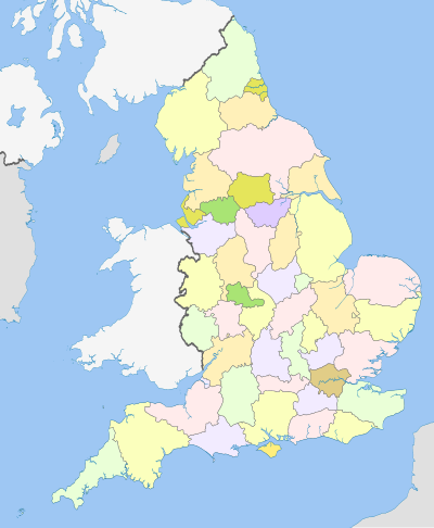
เขตเลฟเทนันซีตั้งแต่ปี 1997
[แก้]ต่อไปนี้คือเทศมณฑลเพื่อวัตถุประสงค์ของเลฟเทนันซีในประเทศอังกฤษ ซึ่งปัจจุบันมีทั้งหมด 48 แห่ง ดังนี้
| เทศมณฑล เพื่อวัตถุประสงค์ ของเลฟเทนันซี |
ประชากร (2018)[5][6] |
พื้นที่ | ความหนาแน่น | องค์ประกอบ เทศมณฑลมหานคร และเทศมณฑลนอกมหานคร หรือ เขตองค์กรปกครองหน่วยเดียว | |||||
|---|---|---|---|---|---|---|---|---|---|
| จำนวน | อันดับ | (ตร.กม.) | (ตร.ไมล์) | อันดับ | (คน/ตร.กม.) | (คน/ตร.ไมล์) | อันดับ | ||
| เบดฟอร์ดเชอร์ | 669,338 | 36 | 1,235 | 477 | 41 | 542 | 1,400 | 13th | Bedford, Central Bedfordshire และ Luton |
| บาร์กเชอร์ | 911,403 | 24 | 1,262 | 487 | 40 | 722 | 1,870 | 10th | Bracknell Forest, Reading, Slough, West Berkshire, Windsor and Maidenhead และ Wokingham |
| บริสตอล | 463,405 | 43 | 110 | 42 | 47 | 4,224 | 10,940 | 2nd | Bristol |
| บักกิงแฮมเชอร์ | 808,666 | 30 | 1,874 | 724 | 32 | 432 | 1,120 | 22nd | Buckinghamshire และ Milton Keynes |
| เคมบริดจ์เชอร์ | 852,523 | 28 | 3,390 | 1,310 | 15 | 252 | 650 | 34th | Cambridgeshire และ Peterborough |
| เชชเชอร์ | 1,059,271 | 19 | 2,343 | 905 | 25 | 452 | 1,170 | 21st | Cheshire East, Cheshire West and Chester, Halton, และ Warrington |
| นครลอนดอน[หมายเหตุ 1] | 8,706 | 48 | 2.90 | 1.12 | 48 | 2,998 | 7,760 | 4th | City of London |
| คอร์นวอลล์ | 568,210 | 40 | 3,562 | 1,375 | 12 | 160 | 410 | 41st | Cornwall และ Isles of Scilly |
| คัมเบรีย | 498,888 | 41 | 6,767 | 2,613 | 3 | 74 | 190 | 47th | Cumbria |
| ดาร์บิเชอร์ | 1,053,316 | 21 | 2,625 | 1,014 | 21 | 401 | 1,040 | 25th | Derbyshire และ Derby |
| เดวอน | 1,194,166 | 11 | 6,707 | 2,590 | 4 | 178 | 460 | 39th | Devon, Plymouth และ Torbay |
| ดอร์เซต | 772,268 | 31 | 2,653 | 1,024 | 20 | 274 | 710 | 32nd | Dorset และ Bournemouth, Christchurch and Poole[7] |
| เดอรัม | 866,846 | 26 | 2,676 | 1,033 | 19 | 324 | 840 | 28th | County Durham, Darlington, Hartlepool และส่วนหนึ่งของ Stockton-on-Tees เฉพาะฝั่งเหนือของแนวกึ่งกลางแม่น้ำทีส์ (River Tees) |
| อีสต์ไรดิงออฟยอร์กเชอร์ | 600,259 | 37 | 2,477 | 956 | 23 | 242 | 630 | 35th | East Riding of Yorkshire และ Kingston-upon-Hull |
| อีสต์ซัสเซกซ์ | 844,985 | 29 | 1,791 | 692 | 33 | 472 | 1,220 | 20th | East Sussex และ Brighton and Hove |
| เอสเซกซ์ | 1,832,752 | 7 | 3,670 | 1,420 | 11 | 499 | 1,290 | 15th | Essex, Southend-on-Sea และ Thurrock |
| กลอสเตอร์เชอร์ | 916,202 | 23 | 3,150 | 1,220 | 16 | 291 | 750 | 30th | Gloucestershire และ South Gloucestershire |
| เกรเทอร์ลอนดอน | 8,899,375 | 1 | 1,569 | 606 | 37 | 5,671 | 14,690 | 1st | London boroughs |
| เกรเทอร์แมนเชสเตอร์ | 2,812,569 | 3 | 1,276 | 493 | 39 | 2,204 | 5,710 | 5th | Greater Manchester |
| แฮมป์เชอร์ | 1,844,245 | 6 | 3,769 | 1,455 | 9 | 489 | 1,270 | 17th | Hampshire, Portsmouth และ Southampton |
| เฮริฟอร์ดเชอร์ | 192,107 | 45 | 2,180 | 840 | 26 | 88 | 230 | 46th | Herefordshire |
| ฮาร์ตฟอร์ดเชอร์ | 1,184,365 | 13 | 1,643 | 634 | 36 | 721 | 1,870 | 11th | Hertfordshire |
| ไอล์ออฟไวต์ | 141,538 | 46 | 380 | 150 | 46 | 372 | 960 | 26th | Isle of Wight |
| เคนต์ | 1,846,478 | 5 | 3,738 | 1,443 | 10 | 494 | 1,280 | 16th | Kent and Medway |
| แลงคาเชอร์ | 1,498,300 | 8 | 3,075 | 1,187 | 17 | 487 | 1,260 | 19th | Blackburn with Darwen, Blackpool และ Lancashire |
| เลสเตอร์เชอร์ | 1,053,486 | 20 | 2,156 | 832 | 28 | 489 | 1,270 | 18th | Leicestershire และ Leicester |
| ลิงคอล์นเชอร์ | 1,087,659 | 18 | 6,975 | 2,693 | 2 | 156 | 400 | 42nd | Lincolnshire, North Lincolnshire และ North East Lincolnshire |
| เมอร์ซีย์ไซด์ | 1,423,065 | 9 | 647 | 250 | 43 | 2,200 | 5,700 | 6th | Merseyside |
| นอร์ฟอล์ก | 903,680 | 25 | 5,380 | 2,080 | 5 | 168 | 440 | 40th | Norfolk |
| นอร์ทยอร์กเชอร์ | 1,158,816 | 14 | 8,654 | 3,341 | 1 | 134 | 350 | 44th | Middlesbrough, North Yorkshire, Redcar and Cleveland, York และส่วนหนึ่ง Stockton-on-Tees เฉพาะฝั่งใต้ของแนวกึ่งกลางแม่น้ำทีส์ (River Tees) |
| นอร์แทมป์ตันเชอร์ | 747,622 | 33 | 2,364 | 913 | 24 | 316 | 820 | 29th | Northamptonshire |
| นอร์ทัมเบอร์แลนด์ | 320,274 | 44 | 5,014 | 1,936 | 6 | 64 | 170 | 48th | Northumberland |
| นอตทิงแฮมเชอร์ | 1,154,195 | 15 | 2,159 | 834 | 27 | 535 | 1,390 | 14th | Nottinghamshire และ Nottingham |
| ออกซฟอร์ดเชอร์ | 687,524 | 35 | 2,605 | 1,006 | 22 | 264 | 680 | 33rd | Oxfordshire |
| รัตแลนด์ | 39,697 | 47 | 382 | 147 | 45 | 104 | 270 | 45th | Rutland |
| ชรอปเชอร์ | 498,073 | 42 | 3,488 | 1,347 | 13 | 143 | 370 | 43rd | Shropshire และ Telford and Wrekin |
| ซัมเมอร์เซต | 965,424 | 22 | 4,170 | 1,610 | 7 | 232 | 600 | 36th | Bath and North East Somerset, North Somerset และ Somerset |
| เซาท์ยอร์กเชอร์ | 1,402,918 | 10 | 1,552 | 599 | 38 | 904 | 2,340 | 9th | South Yorkshire |
| สแตฟฟอร์ดเชอร์ | 1,131,052 | 17 | 2,714 | 1,048 | 18 | 417 | 1,080 | 24th | Staffordshire และ Stoke-on-Trent |
| ซัฟฟอล์ก | 758,556 | 32 | 3,801 | 1,468 | 8 | 200 | 520 | 38th | Suffolk |
| เซอร์รีย์ | 1,189,934 | 12 | 1,663 | 642 | 35 | 716 | 1,850 | 12th | Surrey |
| ไทน์และเวียร์ | 1,136,371 | 16 | 540 | 210 | 44 | 2,105 | 5,450 | 7th | Tyne and Wear |
| วอร์ริกเชอร์ | 571,010 | 39 | 1,975 | 763 | 31 | 289 | 750 | 31st | Warwickshire |
| เวสต์มิดแลนส์ | 2,916,458 | 2 | 902 | 348 | 42 | 3,235 | 8,380 | 3rd | West Midlands |
| เวสต์ซัสเซกซ์ | 858,852 | 27 | 1,991 | 769 | 30 | 431 | 1,120 | 23rd | West Sussex |
| เวสต์ยอร์กเชอร์ | 2,320,214 | 4 | 2,029 | 783 | 29 | 1,143 | 2,960 | 8th | West Yorkshire |
| วิลต์เชอร์ | 720,060 | 34 | 3,485 | 1,346 | 14 | 207 | 540 | 37th | Swindon และ Wiltshire |
| วุร์สเตอร์เชอร์ | 592,057 | 38 | 1,741 | 672 | 34 | 340 | 880 | 27th | Worcestershire |
ดูเพิ่ม
[แก้]- เทศมณฑลของอังกฤษ
- เทศมณฑลในประวัติศาสตร์อังกฤษ
- เทศมณฑลที่เป็นมหานครและไม่ใช่มหานครของอังกฤษ
- เขตการปกครองของประเทศอังกฤษ
- เทศมณฑลของสหราชอาณาจักร
หมายเหตุ
[แก้]- ↑ เนื่องจากนครลอนดอนมีคณะกรรมการเลฟเทนันซีแทนเลฟเทนันซีคนเดียว นับว่าเป็นเขตพื้นที่เพื่อวัตถุประสงค์บางประการของพระราชบัญญัติเลฟเทนันซี (Schedule 1 paragraph 4)
อ้างอิง
[แก้]- ↑ Table 2 2011 Census: Usual resident population and population density, local authorities in the United Kingdom UK Census 2011 UK usual resident population Greater London excluding City of London
- ↑ Text of the Lieutenancies Act 1997 – Schedule 1: Counties and areas for the purposes of the lieutenancies in Great Britain as in force today (including any amendments) within the United Kingdom, from legislation.gov.uk. Retrieved 2011-05-03.
- ↑ "Ceremonial and Historic county boundary data added to OS OpenData". www.ordnancesurvey.co.uk.
- ↑ "England - Geographic counties". Encyclopædia Britannica.
- ↑ "Population Estimates for UK, England and Wales, Scotland and Northern Ireland, Mid-2019". Office for National Statistics. 6 May 2020. สืบค้นเมื่อ 6 May 2020.
- ↑ "Standard Area Measurements (2016) for Administrative Areas in the United Kingdom". Office for National Statistics. 1 February 2017. สืบค้นเมื่อ 9 February 2017.
- ↑ "The Local Government (Structural and Boundary Changes) (Supplementary Provision and Miscellaneous Amendments) Order 2019".
| สหราชอาณาจักร |
|
|---|---|
| อังกฤษ | |
| สกอตแลนด์ | |
| เวลส์ |
|
| ไอร์แลนด์เหนือ | |
บทความเกี่ยวกับประเทศอังกฤษนี้ยังเป็นโครง คุณสามารถช่วยวิกิพีเดียได้โดยการเพิ่มเติมข้อมูล |