
ไฟล์:French Algeria evolution 1830-1962 map-fr.svg

ขนาดของตัวอย่าง PNG นี้ของไฟล์ SVG นี้: 604 × 600 พิกเซล ความละเอียดอื่น: 242 × 240 พิกเซล | 483 × 480 พิกเซล | 773 × 768 พิกเซล | 1,031 × 1,024 พิกเซล | 2,062 × 2,048 พิกเซล | 1,287 × 1,278 พิกเซล
ดูภาพที่มีความละเอียดสูงกว่า ((ไฟล์ SVG, 1,287 × 1,278 พิกเซล, ขนาดไฟล์: 1.86 เมกะไบต์))
| รูปภาพหรือไฟล์เสียงนี้ ต้นฉบับอยู่ที่ คอมมอนส์ รายละเอียดด้านล่าง เป็นข้อความที่แสดงผลจาก ไฟล์ต้นฉบับในคอมมอนส์
|
ความย่อ
| คำอธิบาย |
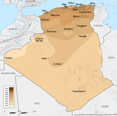
English: French Algeria evolution map, from 1830 to 1962.
Français : Carte montrant l'évolution territoriale de l'Algérie française, de 1830 à 1962.
|
| วันที่ | (UTC) |
| แหล่งที่มา |
English:
Français :
|
| ผู้สร้างสรรค์ | Sémhur |
| เวอร์ชันอื่น |
ไฟล์อื่นที่ใช้ไฟล์นี้: French Algeria evolution 1830-1962 map-es.svg |
| การแสดงที่มา (จำเป็นต้องมีตามสัญญาอนุญาต) | © Sémhur / Wikimedia Commons / |
| SVG genesis |
| ตำแหน่งที่ตั้งกล้อง | | ภาพนี้และภาพอื่น ๆ ณ สถานที่เดียวกันที่ OpenStreetMap |
|---|
การอนุญาตใช้สิทธิ
ข้าพเจ้า ในฐานะผู้ถือลิขสิทธิ์ของภาพหรือสื่อนี้ อนุญาตให้ใช้ภาพหรือสื่อนี้ภายใต้เงื่อนไขต่อไปนี้
| กอปปีเลฟต์: งานศิลปะนี้ไม่มีมูลค่า คุณสามารถแจกจ่ายและ/หรือแก้ไขได้ภายใต้เงื่อนไข Free Art License คุณสามารถพบตัวอย่างของสัญญาอนุญาตนี้ได้บนไซต์ Copyleft Attitude รวมทั้งบนไซต์อื่น ๆ ด้วย |
This file is licensed under the Creative Commons Attribution-Share Alike 4.0 International, 3.0 Unported, 2.5 Generic, 2.0 Generic and 1.0 Generic license.
- คุณสามารถ:
- ที่จะแบ่งปัน – ที่จะทำสำเนา แจกจ่าย และส่งงานดังกล่าวต่อไป
- ที่จะเรียบเรียงใหม่ – ที่จะดัดแปลงงานดังกล่าว
- ภายใต้เงื่อนไขต่อไปนี้:
- แสดงที่มา – คุณต้องให้เกียรติเจ้าของงานอย่างเหมาะสม โดยเพิ่มลิงก์ไปยังสัญญาอนุญาต และระบุหากมีการเปลี่ยนแปลง คุณอาจทำเช่นนี้ได้ในรูปแบบใดก็ได้ตามควร แต่ต้องไม่ใช่ในลักษณะที่แนะว่าผู้ให้อนุญาตสนับสนุนคุณหรือการใช้งานของคุณ
- อนุญาตแบบเดียวกัน – หากคุณดัดแปลง เปลี่ยนรูป หรือต่อเติมงานนี้ คุณต้องใช้สัญญาอนุญาตแบบเดียวกันหรือแบบที่เหมือนกับสัญญาอนุญาตที่ใช้กับงานนี้เท่านั้น
คุณสามารถเลือกสัญญาอนุญาตดังกล่าวตามต้องการ
บันทึกการอัพโหลด
This image is a derivative work of the following images:
- File:Algeria_location_map.svg licensed with Cc-by-sa-3.0, GFDL
- 2009-11-17T12:51:26Z Sting 1287x1278 (372657 Bytes) == {{int:filedesc}} == {{Location|28|19|00|N|1|39|00|E|scale:8000000}} {{Information |Description={{en|Blank administrative map of [[:en:Algeria|Algeria]], for geo-location purposes.}} {{fr|Carte administrative vierge de l'[
Uploaded with derivativeFX
ประวัติไฟล์
คลิกวันที่/เวลาเพื่อดูไฟล์ที่ปรากฏในขณะนั้น
| วันที่/เวลา | รูปย่อ | ขนาด | ผู้ใช้ | ความเห็น | |
|---|---|---|---|---|---|
| ปัจจุบัน | 02:34, 23 พฤษภาคม 2557 | | 1,287 × 1,278 (1.86 เมกะไบต์) | Sémhur | Valid SVG |
| 01:57, 30 กันยายน 2555 |  | 1,287 × 1,278 (1.86 เมกะไบต์) | Sémhur | == {{int:filedesc}} == {{Information |Description={{Multilingual description |en= en:French Algeria evolution map, from 1830 to 1962. |fr= Carte de l'fr:Algérie française, de 1830 à 1962. }} <br/> Scale: 1:6,800,000 (precision: 1,700 m)... |
หน้าที่มีภาพนี้
หน้าต่อไปนี้ โยงมาที่ภาพนี้:
การใช้ไฟล์ข้ามโครงการ
วิกิอื่นต่อไปนี้ใช้ไฟล์นี้:
- การใช้บน ast.wikipedia.org
- การใช้บน bg.wikipedia.org
- การใช้บน ca.wikipedia.org
- การใช้บน da.wikipedia.org
- การใช้บน de.wikipedia.org
- การใช้บน en.wikipedia.org
- การใช้บน eu.wikipedia.org
- การใช้บน fa.wikipedia.org
- การใช้บน fi.wikipedia.org
- การใช้บน fr.wikipedia.org
- การใช้บน ga.wikipedia.org
- การใช้บน hy.wikipedia.org
- การใช้บน id.wikipedia.org
- การใช้บน it.wikipedia.org
- การใช้บน ja.wikipedia.org
- การใช้บน ka.wikipedia.org
- การใช้บน ko.wikipedia.org
- การใช้บน lt.wikipedia.org
- การใช้บน lv.wikipedia.org
- การใช้บน mk.wikipedia.org
- การใช้บน ms.wikipedia.org
- การใช้บน mt.wikipedia.org
- การใช้บน nl.wikipedia.org
- การใช้บน pl.wikipedia.org
- การใช้บน pnb.wikipedia.org
- การใช้บน pt.wikipedia.org
- การใช้บน ro.wikipedia.org
- การใช้บน ru.wikipedia.org
ดูการใช้ข้ามโครงการเพิ่มเติมของไฟล์นี้