
ไฟล์:United Kingdom United States Locator.svg

ขนาดของตัวอย่าง PNG นี้ของไฟล์ SVG นี้: 800 × 353 พิกเซล ความละเอียดอื่น: 320 × 141 พิกเซล | 640 × 283 พิกเซล | 1,024 × 452 พิกเซล | 1,280 × 565 พิกเซล | 2,560 × 1,130 พิกเซล | 940 × 415 พิกเซล
ดูภาพที่มีความละเอียดสูงกว่า ((ไฟล์ SVG, 940 × 415 พิกเซล, ขนาดไฟล์: 2.56 เมกะไบต์))
| รูปภาพหรือไฟล์เสียงนี้ ต้นฉบับอยู่ที่ คอมมอนส์ รายละเอียดด้านล่าง เป็นข้อความที่แสดงผลจาก ไฟล์ต้นฉบับในคอมมอนส์
|
ความย่อ
| คำอธิบาย |
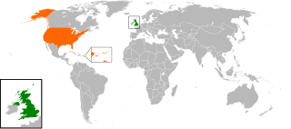
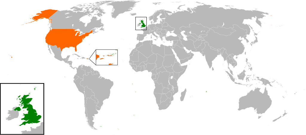
English: Map of the world showing the location of the United Kingdom and the United States of America. |
| วันที่ | |
| แหล่งที่มา | งานของตัว |
| ผู้สร้างสรรค์ | Jolly Janner |
การอนุญาตใช้สิทธิ
| ข้าพเจ้า ผู้ถือลิขสิทธิ์ในงานนี้ ขอมอบงานให้เป็นสาธารณสมบัติ ประกาศนี้มีผลทั่วโลก ในบางประเทศ การกระทำดังกล่าวอาจไม่สามารถทำได้ตามกฎหมาย ข้าพเจ้าอนุญาตให้ทุกคนมีสิทธิ์ในการใช้ไฟล์นี้ในทุกเหตุผลการใช้ โดยไม่มีมีเงื่อนไข เว้นแต่กฎหมายไม่อนุญาตให้ทำเช่นนั้น |
ประวัติไฟล์
คลิกวันที่/เวลาเพื่อดูไฟล์ที่ปรากฏในขณะนั้น
| วันที่/เวลา | รูปย่อ | ขนาด | ผู้ใช้ | ความเห็น | |
|---|---|---|---|---|---|
| ปัจจุบัน | 23:00, 20 มีนาคม 2560 | | 940 × 415 (2.56 เมกะไบต์) | RaviC | add dependencies, inset map for Virgin Islands region where both states share a maritime border |
| 09:43, 24 ธันวาคม 2559 |  | 940 × 415 (1.79 เมกะไบต์) | BurritoBazooka | put all Faroe islands except Suðuroy region behind black border of UK box. Make two boxes (transparent group rectangle and white bg rectangle) same stroke thickness. | |
| 07:43, 24 ธันวาคม 2559 |  | 940 × 415 (1.79 เมกะไบต์) | BurritoBazooka | add France and Faroe Islands to UK box by re-cutting it from its place on the map (b/c why should ROI, another sovereign state, be shown, and not France and the Faroe Islands?) Also the box has its own group now. | |
| 07:34, 24 ธันวาคม 2559 |  | 940 × 415 (1.78 เมกะไบต์) | BurritoBazooka | French Polynesia, Pitcairn Islands were showing in the UK box, but these are not in the same area as the British Isles at all. Also, are Falklands etc not on the same level as Puerto Rico? | |
| 01:38, 8 ธันวาคม 2559 |  | 940 × 415 (1.78 เมกะไบต์) | Mikey641 | Accident | |
| 01:38, 8 ธันวาคม 2559 |  | 512 × 226 (753 กิโลไบต์) | Mikey641 | -- | |
| 01:09, 4 มีนาคม 2556 |  | 940 × 415 (1.78 เมกะไบต์) | Timothy Gu | +South Sudan (w/ small Britain map) | |
| 04:25, 3 มีนาคม 2555 |  | 940 × 415 (1.63 เมกะไบต์) | Jrobin08 | Reverted to version as of 20:37, 24 June 2009 (Easier to see the United Kingdom. Maybe someone can add South Sudan to the map, but keep the UK zoom box in.) | |
| 04:05, 24 กันยายน 2554 |  | 940 × 415 (1.76 เมกะไบต์) | Bazonka2 | + South Sudan | |
| 03:37, 25 มิถุนายน 2552 |  | 940 × 415 (1.63 เมกะไบต์) | Jolly Janner | {{Information |Description={{en|1=Map of the world showing the location of the United Kingdom and the United States of America.}} |Source=Own work by uploader |Author=Jolly Janner |Date=2009-0 |
หน้าที่มีภาพนี้
หน้าต่อไปนี้ โยงมาที่ภาพนี้:
การใช้ไฟล์ข้ามโครงการ
วิกิอื่นต่อไปนี้ใช้ไฟล์นี้:
- การใช้บน ar.wikipedia.org
- การใช้บน ca.wikipedia.org
- การใช้บน de.wikipedia.org
- การใช้บน en.wikipedia.org
- การใช้บน es.wikipedia.org
- การใช้บน fr.wikipedia.org
- การใช้บน he.wikipedia.org
- การใช้บน hy.wikipedia.org
- การใช้บน id.wikipedia.org
- การใช้บน it.wikipedia.org
- การใช้บน ja.wikipedia.org
- การใช้บน ps.wikipedia.org
- การใช้บน pt.wikipedia.org
- การใช้บน ru.wikipedia.org
- การใช้บน tr.wikipedia.org
- การใช้บน uk.wikipedia.org
- การใช้บน www.wikidata.org
- การใช้บน zh.wikipedia.org