
ไฟล์:ShakeMap - 2009 West Java earthquake.pdf

ขนาดของตัวอย่าง JPG นี้ของไฟล์ PDF นี้: 473 × 600 พิกเซล ความละเอียดอื่น: 189 × 240 พิกเซล | 379 × 480 พิกเซล | 606 × 768 พิกเซล | 1,229 × 1,558 พิกเซล
ดูภาพที่มีความละเอียดสูงกว่า (1,229 × 1,558 พิกเซล, ขนาดไฟล์: 1.21 เมกะไบต์, ชนิดไมม์: application/pdf)
| รูปภาพหรือไฟล์เสียงนี้ ต้นฉบับอยู่ที่ คอมมอนส์ รายละเอียดด้านล่าง เป็นข้อความที่แสดงผลจาก ไฟล์ต้นฉบับในคอมมอนส์
|
ความย่อ
| คำอธิบาย |
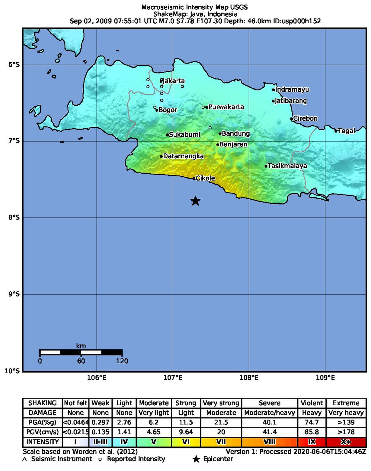
English: ShakeMap of the 7.0-magnitude 2009 West Java earthquake. |
| วันที่ | |
| แหล่งที่มา | https://earthquake.usgs.gov/earthquakes/eventpage/usp000h152/shakemap/intensity?source=atlas&code=usp000h152 |
| ผู้สร้างสรรค์ | United States Geological Survey |
การอนุญาตใช้สิทธิ
This image is in the public domain in the United States because it only contains materials that originally came from the United States Geological Survey, an agency of the United States Department of the Interior. For more information, see the official USGS copyright policy.
|
ประวัติไฟล์
คลิกวันที่/เวลาเพื่อดูไฟล์ที่ปรากฏในขณะนั้น
| วันที่/เวลา | รูปย่อ | ขนาด | ผู้ใช้ | ความเห็น | |
|---|---|---|---|---|---|
| ปัจจุบัน | 20:58, 23 ตุลาคม 2564 |  | 1,229 × 1,558 (1.21 เมกะไบต์) | Oscitare | Uploaded a work by w:United States Geological Survey from https://earthquake.usgs.gov/earthquakes/eventpage/usp000h152/shakemap/intensity?source=atlas&code=usp000h152 with UploadWizard |
หน้าที่มีภาพนี้
หน้าต่อไปนี้ โยงมาที่ภาพนี้:
การใช้ไฟล์ข้ามโครงการ
วิกิอื่นต่อไปนี้ใช้ไฟล์นี้:
- การใช้บน en.wikipedia.org
- การใช้บน id.wikipedia.org