
ไฟล์:Mawar 2023-05-26 0405Z.jpg

ขนาดของตัวอย่างนี้: 462 × 599 พิกเซล ความละเอียดอื่น: 185 × 240 พิกเซล | 370 × 480 พิกเซล | 592 × 768 พิกเซล | 789 × 1,024 พิกเซล | 1,579 × 2,048 พิกเซล | 3,700 × 4,800 พิกเซล
ดูภาพที่มีความละเอียดสูงกว่า (3,700 × 4,800 พิกเซล, ขนาดไฟล์: 12.01 เมกะไบต์, ชนิดไมม์: image/jpeg)
| รูปภาพหรือไฟล์เสียงนี้ ต้นฉบับอยู่ที่ คอมมอนส์ รายละเอียดด้านล่าง เป็นข้อความที่แสดงผลจาก ไฟล์ต้นฉบับในคอมมอนส์
|
ความย่อ
| คำอธิบาย |
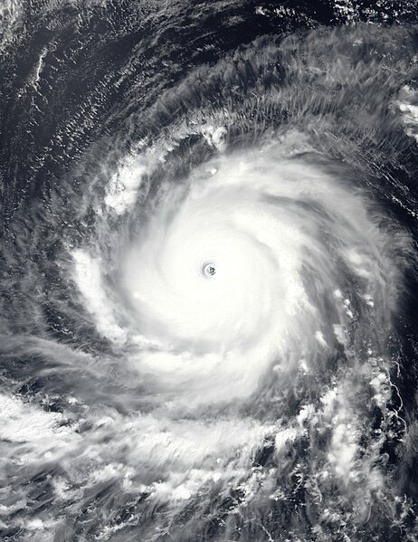
English: This true-color image of Typhoon Mawar (later known as "Betty" in the Philippines) over the Philippine Sea was captured on the afternoon of May 26, 2023, at 04:05 UTC, by the Visible Infrared Imaging Radiometer Suite (VIIRS) instrument flying aboard NOAA's Suomi-NPP satellite. Mawar was an extremely powerful typhoon that affected parts of the Indo-Pacific, particularly Guam, the Mariana Islands, the Philippines, and Taiwan, and the Southern Japanese Islands. The fourth depression, the second named storm (officially), the first typhoon, and the first violent typhoon of the 2023 West Pacific typhoon season. It originated from a tropical disturbance near Micronesia in mid-May 2023, where it began its track in a northwestward direction through the Mariana Islands and toward Guam. On May 24, Mawar passed by Guam, causing at least $4.3 billion (2023) in damage to the Island Territory. Mawar has contributed to six causalities in total two in Guam, one in Taiwan, one in the Philippines, and two in Japan. When this image was taken, Mawar was at its secondary and most intense peak intensity and moving west toward the Philippine Islands. The intensity of the typhoon when this image was taken was winds of 210 km/h (130 mph) (115 knots) on the 10-min Japan Meteorological Agency typhoon scale, making it a "Violent typhoon" on the scale, and according to the Joint Typhoon Warning Center, it had 1-min sustained winds of 295 km/h (185 mph) (160 knots) making it equivalent to an extremely powerful "Category 5 major hurricane," on the Saffir-Simpson Hurricane Wind Scale the fifth to reach that intensity during the year so far. The official minimum central pressure (provided by the JMA) was 900 mbar (26.6 inHg) and its unofficial minimum pressure (provided by the JTWC) was 897 mbar (26.5 inHg), this makes Mawar one of the most intense typhoons to occur in May in the Western Pacific basin, and so far the most intense globally during the current calendar year tied with Typhoon Bolaven in October. |
| วันที่ | |
| แหล่งที่มา | EOSDIS Worldview |
| ผู้สร้างสรรค์ | VIIRS imagery from NOAA's Suomi-NPP Satellite |
การอนุญาตใช้สิทธิ
This image is in the public domain because it contains materials that originally came from the U.S. National Oceanic and Atmospheric Administration, taken or made as part of an employee's official duties.
|
ประวัติไฟล์
คลิกวันที่/เวลาเพื่อดูไฟล์ที่ปรากฏในขณะนั้น
| วันที่/เวลา | รูปย่อ | ขนาด | ผู้ใช้ | ความเห็น | |
|---|---|---|---|---|---|
| ปัจจุบัน | 04:16, 27 พฤษภาคม 2566 | | 3,700 × 4,800 (12.01 เมกะไบต์) | TheWxResearcher | Tweaked Brightness |
| 04:00, 27 พฤษภาคม 2566 |  | 3,700 × 4,800 (11.1 เมกะไบต์) | TheWxResearcher | Uploaded a work by VIIRS imagery from NOAA's Suomi-NPP Satellite from [https://worldview.earthdata.nasa.gov/ EOSDIS Worldview] with UploadWizard |
หน้าที่มีภาพนี้
หน้าต่อไปนี้ โยงมาที่ภาพนี้:
การใช้ไฟล์ข้ามโครงการ
วิกิอื่นต่อไปนี้ใช้ไฟล์นี้:
- การใช้บน en.wikipedia.org
- การใช้บน es.wikipedia.org
- การใช้บน ja.wikipedia.org
- การใช้บน ko.wikipedia.org
- การใช้บน pt.wikipedia.org
- การใช้บน tl.wikipedia.org
- การใช้บน uk.wikipedia.org
- การใช้บน www.wikidata.org
- การใช้บน zh.wikipedia.org