
ไฟล์:7 - Itahuania - Août 2008.JPG

ดูภาพที่มีความละเอียดสูงกว่า (2,592 × 1,944 พิกเซล, ขนาดไฟล์: 2.12 เมกะไบต์, ชนิดไมม์: image/jpeg)
| รูปภาพหรือไฟล์เสียงนี้ ต้นฉบับอยู่ที่ คอมมอนส์ รายละเอียดด้านล่าง เป็นข้อความที่แสดงผลจาก ไฟล์ต้นฉบับในคอมมอนส์
|
ความย่อ
| คำอธิบาย |
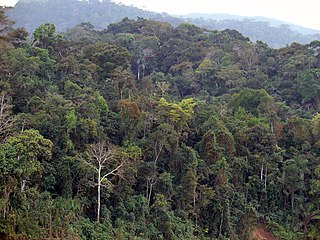
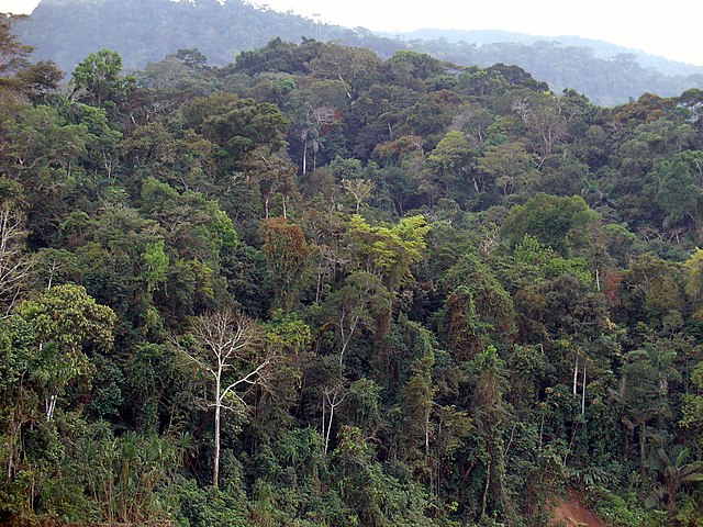
Français : Forêt amazonienne depuis la rivière Alto Madre de Dios, au Pérou
English: Amazon Rainforest, seen from the Alto Madre de Dios river, in Peru
Español: Vista de la selva amazónica desde el alto Madre de Dios, en el Perú |
||
| วันที่ | |||
| แหล่งที่มา | งานของตัว | ||
| ผู้สร้างสรรค์ | Martin St-Amant (S23678) | ||
| การอนุญาต (การใช้ไฟล์นี้ใหม่) |
|

| ตำแหน่งที่ตั้งกล้อง | | ภาพนี้และภาพอื่น ๆ ณ สถานที่เดียวกันที่ OpenStreetMap |
|---|
การอนุญาตใช้สิทธิ
- คุณสามารถ:
- ที่จะแบ่งปัน – ที่จะทำสำเนา แจกจ่าย และส่งงานดังกล่าวต่อไป
- ที่จะเรียบเรียงใหม่ – ที่จะดัดแปลงงานดังกล่าว
- ภายใต้เงื่อนไขต่อไปนี้:
- แสดงที่มา – คุณต้องให้เกียรติเจ้าของงานอย่างเหมาะสม โดยเพิ่มลิงก์ไปยังสัญญาอนุญาต และระบุหากมีการเปลี่ยนแปลง คุณอาจทำเช่นนี้ได้ในรูปแบบใดก็ได้ตามควร แต่ต้องไม่ใช่ในลักษณะที่แนะว่าผู้ให้อนุญาตสนับสนุนคุณหรือการใช้งานของคุณ
- อนุญาตแบบเดียวกัน – หากคุณดัดแปลง เปลี่ยนรูป หรือต่อเติมงานนี้ คุณต้องใช้สัญญาอนุญาตแบบเดียวกันหรือแบบที่เหมือนกับสัญญาอนุญาตที่ใช้กับงานนี้เท่านั้น
ประวัติไฟล์
คลิกวันที่/เวลาเพื่อดูไฟล์ที่ปรากฏในขณะนั้น
| วันที่/เวลา | รูปย่อ | ขนาด | ผู้ใช้ | ความเห็น | |
|---|---|---|---|---|---|
| ปัจจุบัน | 22:30, 28 มีนาคม 2552 | | 2,592 × 1,944 (2.12 เมกะไบต์) | S23678 | == Description == {{Information |Description={{User:S23678/Traduction}} {{fr|1=Forêt amazonienne depuis la rivière Alto Madre de Dios, au Pérou}} {{en|1=Amazon Rainforest, seen from the Alto Madre de Dios river, in Peru}} |Source=travail personnel (own |
หน้าที่มีภาพนี้
หน้าต่อไปนี้ โยงมาที่ภาพนี้:
การใช้ไฟล์ข้ามโครงการ
วิกิอื่นต่อไปนี้ใช้ไฟล์นี้:
- การใช้บน bn.wikipedia.org
- การใช้บน br.wikipedia.org
- การใช้บน ca.wikipedia.org
- การใช้บน ceb.wikipedia.org
- การใช้บน cs.wikipedia.org
- การใช้บน de.wikipedia.org
- การใช้บน en.wikipedia.org
- การใช้บน eo.wikipedia.org
- การใช้บน es.wikipedia.org
- การใช้บน eu.wikipedia.org
- การใช้บน fa.wikipedia.org
- การใช้บน fr.wikipedia.org
- การใช้บน ga.wikipedia.org
- การใช้บน gl.wikipedia.org
- การใช้บน gl.wiktionary.org
- การใช้บน hi.wikipedia.org
- การใช้บน id.wikipedia.org
- การใช้บน it.wikipedia.org
- การใช้บน ja.wikipedia.org
- การใช้บน ko.wikipedia.org
- การใช้บน ky.wikipedia.org
- การใช้บน lv.wikipedia.org
- การใช้บน mk.wikipedia.org
- การใช้บน no.wikipedia.org
- การใช้บน pl.wikipedia.org
- การใช้บน pt.wikipedia.org
- การใช้บน sh.wikipedia.org
- การใช้บน sr.wikipedia.org
- การใช้บน tr.wikipedia.org
ดูการใช้ข้ามโครงการเพิ่มเติมของไฟล์นี้