
ไฟล์:Mt Vesuvius 79 AD eruption.svg

ขนาดของตัวอย่าง PNG นี้ของไฟล์ SVG นี้: 800 × 482 พิกเซล ความละเอียดอื่น: 320 × 193 พิกเซล | 640 × 386 พิกเซล | 1,024 × 617 พิกเซล | 1,280 × 771 พิกเซล | 2,560 × 1,542 พิกเซล
ดูภาพที่มีความละเอียดสูงกว่า ((ไฟล์ SVG, 800 × 482 พิกเซล, ขนาดไฟล์: 87 กิโลไบต์))
| รูปภาพหรือไฟล์เสียงนี้ ต้นฉบับอยู่ที่ คอมมอนส์ รายละเอียดด้านล่าง เป็นข้อความที่แสดงผลจาก ไฟล์ต้นฉบับในคอมมอนส์
|
ความย่อ
| คำอธิบาย |
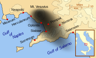
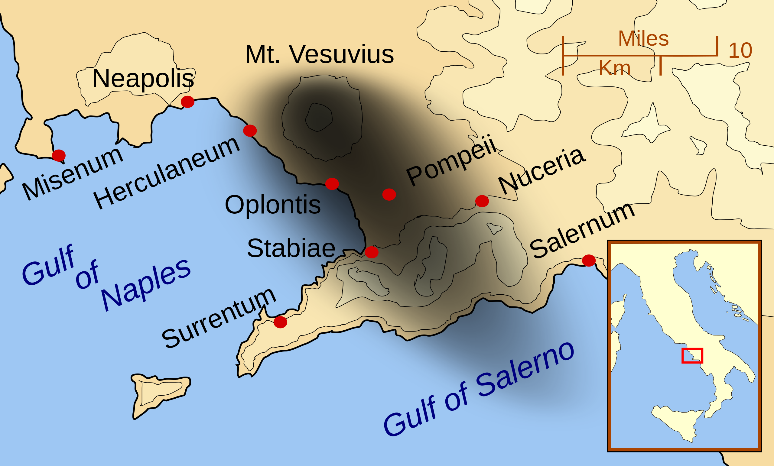
English: A map showing the cities and towns affected by the eruption of Mount Vesuvius in 79 AD. The general shape of the ash and cinder fall (see w:en:pyroclast) is shown by the dark area to the southeast of Mt Vesuvius. (P.S. It seems strange to show the modern day English names for the two bodies of water - I am open to suggestions).
This map shows lines and uses the Mercator projection (although that is not important on a map of this scale). North is, as usual, at the top of the map. |
| วันที่ | |
| แหล่งที่มา | งานของตัว |
| ผู้สร้างสรรค์ | MapMaster |
| เวอร์ชันอื่น |
[]
|


|
ไฟล์ SVG นี้มีข้อความที่สามารถแปลได้ โดยใช้เครื่องมือแปบภาษา SVG หรือใช้ตัวแก้ไข SVG ใดก็ได้ สำหรับข้อมูลเพิ่มเติม ดูที่เกี่ยวกับการแปลไฟล์ |
การอนุญาตใช้สิทธิ
ข้าพเจ้า ในฐานะผู้ถือลิขสิทธิ์ของภาพหรือสื่อนี้ อนุญาตให้ใช้ภาพหรือสื่อนี้ภายใต้เงื่อนไขต่อไปนี้

|
อนุญาตให้คัดลอก แจกจ่ายและ/หรือดัดแปรเอกสารนี้ภายใต้เงื่อนไขของสัญญาอนุญาตเอกสารเสรีของกนู รุ่น 1.2 หรือรุ่นใด ๆ นับจากนี้ที่ออกโดยมูลนิธิซอฟต์แวร์เสรี โดยไม่มีส่วนใดห้ามแก้ไข ไม่มีข้อความปกหน้าและปกหลัง สำเนาของสัญญาอนุญาตรวมอยู่ในส่วนชื่อ สัญญาอนุญาตเอกสารเสรีของกนู |
ไฟล์นี้อยู่ภายใต้สัญญาอนุญาตครีเอทีฟคอมมอนส์ รุ่นแสดงที่มา-อนุญาตแบบเดียวกัน 3.0 ต้นฉบับ, 2.5 ทั่วไป, 2.0 ทั่วไป และ 1.0 ทั่วไป
- คุณสามารถ:
- ที่จะแบ่งปัน – ที่จะทำสำเนา แจกจ่าย และส่งงานดังกล่าวต่อไป
- ที่จะเรียบเรียงใหม่ – ที่จะดัดแปลงงานดังกล่าว
- ภายใต้เงื่อนไขต่อไปนี้:
- แสดงที่มา – คุณต้องให้เกียรติเจ้าของงานอย่างเหมาะสม โดยเพิ่มลิงก์ไปยังสัญญาอนุญาต และระบุหากมีการเปลี่ยนแปลง คุณอาจทำเช่นนี้ได้ในรูปแบบใดก็ได้ตามควร แต่ต้องไม่ใช่ในลักษณะที่แนะว่าผู้ให้อนุญาตสนับสนุนคุณหรือการใช้งานของคุณ
- อนุญาตแบบเดียวกัน – หากคุณดัดแปลง เปลี่ยนรูป หรือต่อเติมงานนี้ คุณต้องใช้สัญญาอนุญาตแบบเดียวกันหรือแบบที่เหมือนกับสัญญาอนุญาตที่ใช้กับงานนี้เท่านั้น
คุณสามารถเลือกสัญญาอนุญาตดังกล่าวตามต้องการ
| Annotations | This image is annotated: View the annotations at Commons |
ประวัติไฟล์
คลิกวันที่/เวลาเพื่อดูไฟล์ที่ปรากฏในขณะนั้น
| วันที่/เวลา | รูปย่อ | ขนาด | ผู้ใช้ | ความเห็น | |
|---|---|---|---|---|---|
| ปัจจุบัน | 08:55, 24 กุมภาพันธ์ 2557 | | 800 × 482 (87 กิโลไบต์) | Ras67 | ditto |
| 08:42, 24 กุมภาพันธ์ 2557 |  | 644 × 388 (88 กิโลไบต์) | Ras67 | frame removed | |
| 08:07, 16 ตุลาคม 2550 |  | 652 × 396 (113 กิโลไบต์) | MapMaster | corrected mis-named Gulf of Salerno | |
| 11:02, 15 ตุลาคม 2550 |  | 652 × 396 (112 กิโลไบต์) | MapMaster | Dropped Title sqaure, and added towns and names of the 2 bays. | |
| 12:16, 14 ตุลาคม 2550 |  | 652 × 454 (126 กิโลไบต์) | MapMaster | Minor changes made after seeing how it's rendered by Wikimedia | |
| 12:11, 14 ตุลาคม 2550 |  | 355 × 247 (125 กิโลไบต์) | MapMaster | {{Information |Description=A map showing the cities and town affected by the eruption of Mount Vesuvius in 79 AD. The general shape of the ash and cinder fall is shown by the dark area to the southeast of Mt Vesuvious. |Source=self-made |Date=October 200 |
หน้าที่มีภาพนี้
หน้าต่อไปนี้ โยงมาที่ภาพนี้:
การใช้ไฟล์ข้ามโครงการ
วิกิอื่นต่อไปนี้ใช้ไฟล์นี้:
- การใช้บน ar.wikipedia.org
- การใช้บน bn.wikipedia.org
- การใช้บน ca.wikipedia.org
- การใช้บน cs.wikipedia.org
- การใช้บน da.wikipedia.org
- การใช้บน de.wikipedia.org
- การใช้บน el.wikipedia.org
- การใช้บน en.wikipedia.org
- การใช้บน eo.wikipedia.org
- การใช้บน es.wikipedia.org
- การใช้บน eu.wikipedia.org
- การใช้บน fa.wikipedia.org
- การใช้บน fi.wikipedia.org
- การใช้บน fr.wikipedia.org
- การใช้บน ga.wikipedia.org
- การใช้บน gl.wikipedia.org
- การใช้บน he.wikipedia.org
- การใช้บน hr.wikipedia.org
- การใช้บน hu.wikipedia.org
- การใช้บน hyw.wikipedia.org
- การใช้บน id.wikipedia.org
- การใช้บน is.wikipedia.org
ดูการใช้ข้ามโครงการเพิ่มเติมของไฟล์นี้