ไฟล์:Mauryan Empire Map.gif

ไม่รองรับเนื้อหาของหน้าในภาษาอื่น
จากวิกิพีเดีย สารานุกรมเสรี

Mauryan_Empire_Map.gif(400 × 337 พิกเซล, ขนาดไฟล์: 11 กิโลไบต์, ชนิดไมม์: image/gif)

Wikimedia Commons logo รูปภาพหรือไฟล์เสียงนี้ ต้นฉบับอยู่ที่ คอมมอนส์ รายละเอียดด้านล่าง เป็นข้อความที่แสดงผลจาก ไฟล์ต้นฉบับในคอมมอนส์
คอมมอนส์เป็นเว็บไซต์ในโครงการสำหรับเก็บรวบรวมสื่อเสรี ที่ คุณสามารถช่วยได้
Atlas This map has been uploaded by Electionworld from en.wikipedia.org to enable the Wikimedia Atlas of the World . Original uploader to en.wikipedia.org was Vastu, known as Vastu at en.wikipedia.org. Electionworld is not the creator of this map. Licensing information is below.

ความย่อ

คำอธิบาย
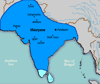
English: A political map of the Mauryan Empire, including notable cities, such as the capital Pataliputra, and site of the Buddha's enlightenment.
this mapis really hard to find txd Green blue represents notable rivers, black represetns modern political borders, and brown represents the border of South Asia. Pataliputra, Sanchi, Ujjain, Bodh Gaya, [[:w:Taxila]|Taxila]]], Mathura, Indraprastha and Pattala Kaushambi, [pryag] are shown.
วันที่ File was made on 03 August 2006, using Paint (software).
แหล่งที่มา Based upon common political maps of the Mauryan Empire, created from this template: Image:Marathas.GIF
ผู้สร้างสรรค์
เวอร์ชันอื่น
ภาพนี้มีภาพในรูปแบบเวกเตอร์ (SVG)
หากภาพ SVG ทำให้การแสดงผลดีกว่า หน้าที่ใช้ภาพนี้ควรเปลี่ยนไปใช้ภาพ SVG แทน

File:Mauryan Empire Map.gif → File:Mauryam Empire map.svg

สำหรับข้อมูลเพิ่มเติมเกี่ยวกับภาพเวกเตอร์ ดูที่ การเปลี่ยนไปใช้ภาพ SVG ในคอมมอนส์
นอกจากนี้สามารถดูเพิ่มเติมเกี่ยวกับ ข้อมูลเกี่ยวกับการรองรับภาพ SVG สำหรับซอฟต์แวร์มีเดียวิกิ ได้

ในภาษาอื่นๆ
Alemannisch  Bahasa Indonesia  Bahasa Melayu  British English  català  čeština  dansk  Deutsch  eesti  English  español  Esperanto  euskara  français  Frysk  galego  hrvatski  Ido  italiano  lietuvių  magyar  Nederlands  norsk bokmål  norsk nynorsk  occitan  Plattdüütsch  polski  português  português do Brasil  română  Scots  sicilianu  slovenčina  slovenščina  suomi  svenska  Tiếng Việt  Türkçe  vèneto  Ελληνικά  беларуская (тарашкевіца)  български  македонски  нохчийн  русский  српски / srpski  татарча/tatarça  українська  ქართული  հայերեն  বাংলা  தமிழ்  മലയാളം  ไทย  한국어  日本語  简体中文  繁體中文  עברית  العربية  فارسی  +/−
ภาพ SVG

การอนุญาตใช้สิทธิ

Public domain งานนี้ได้ถูกเผยแพร่สู่สาธารณสมบัติโดยเจ้าของ Vastu ซึ่งมีผลทั่วโลก

ในบางประเทศ การกระทำดังกล่าวอาจไม่สามารถทำได้ตามกฎหมาย
Vastu อนุญาตให้ทุกคนมีสิทธิ์ในการใช้ไฟล์นี้ในทุกเหตุผลการใช้ โดยไม่มีมีเงื่อนไข เว้นแต่กฎหมายไม่อนุญาตให้ทำเช่นนั้น

คำบรรยายโดยย่อ

เพิ่มคำบรรยายทรรทัดเดียวเพื่อขยายความว่าไฟล์นี้มีอะไร

ไอเทมที่แสดงอยู่ในไฟล์นี้

ประกอบด้วย

media type อังกฤษ

image/gif

ประวัติไฟล์

คลิกวันที่/เวลาเพื่อดูไฟล์ที่ปรากฏในขณะนั้น

วันที่/เวลารูปย่อขนาดผู้ใช้ความเห็น
ปัจจุบัน07:16, 25 มีนาคม 2559รูปย่อสำหรับรุ่นเมื่อ 07:16, 25 มีนาคม 2559400 × 337 (11 กิโลไบต์)LouisAragonrv, changes made by a banned user.
08:14, 23 เมษายน 2550รูปย่อสำหรับรุ่นเมื่อ 08:14, 23 เมษายน 2550400 × 337 (11 กิโลไบต์)Jagged 85
06:02, 14 ธันวาคม 2549รูปย่อสำหรับรุ่นเมื่อ 06:02, 14 ธันวาคม 2549400 × 337 (11 กิโลไบต์)Electionworld{{ew|en|Vastu}} {{ShouldBeSVG}} ==Description== A poltical map of the Mauryan Empire, including notable cities, such as the capital Pataliputra, and site of the Buddha's enlightenment. ===Key=== Dark blue represents the extend of the Maur

ไม่มีหน้าใดโยงมาที่ภาพนี้

การใช้ไฟล์ข้ามโครงการ

วิกิอื่นต่อไปนี้ใช้ไฟล์นี้:

ดูการใช้ข้ามโครงการเพิ่มเติมของไฟล์นี้