
ไฟล์:Mars MOLA Topography by Fabio Crameri.png
ขนาดของตัวอย่างนี้: 800 × 564 พิกเซล ความละเอียดอื่น: 320 × 226 พิกเซล | 640 × 451 พิกเซล | 1,024 × 722 พิกเซล | 1,280 × 902 พิกเซล | 2,481 × 1,749 พิกเซล
ดูภาพที่มีความละเอียดสูงกว่า (2,481 × 1,749 พิกเซล, ขนาดไฟล์: 10.19 เมกะไบต์, ชนิดไมม์: image/png)
| รูปภาพหรือไฟล์เสียงนี้ ต้นฉบับอยู่ที่ คอมมอนส์ รายละเอียดด้านล่าง เป็นข้อความที่แสดงผลจาก ไฟล์ต้นฉบับในคอมมอนส์
|
ความย่อ
| คำอธิบาย |
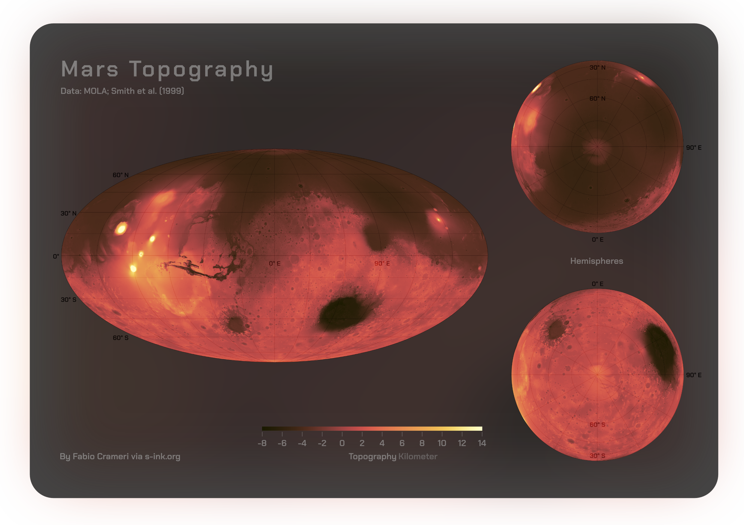
English: Comprehensive global maps by Fabio Crameri shared openly via https://s-ink.org/mars-topography-poster depicting the topography of the Martian surface, featuring polar regions. Represented is the digital elevation model (accessible at https://astrogeology.usgs.gov), derived from Mars Orbiter Laser Altimeter (MOLA) data collected by NASA’s Mars Global Surveyor (MGS) spacecraft (Albee et al., 2001; Smith and Zuber, 1999). The ‘lajolla‘ Scientific color map (see www.fabiocrameri.ch/colourmaps) is used to guarantee precise and color-blind-friendly representation of the data. |
| วันที่ | |
| แหล่งที่มา | งานของตัว |
| ผู้สร้างสรรค์ | FCrameri |
การอนุญาตใช้สิทธิ
ข้าพเจ้า ในฐานะผู้ถือลิขสิทธิ์ของภาพหรือสื่อนี้ อนุญาตให้ใช้ภาพหรือสื่อนี้ภายใต้เงื่อนไขต่อไปนี้
ไฟล์นี้อยู่ภายใต้สัญญาอนุญาต ครีเอทีฟคอมมอนส์ แบบแสดงที่มา-อนุญาตแบบเดียวกัน 4.0 นานาชาติ
- คุณสามารถ:
- ที่จะแบ่งปัน – ที่จะทำสำเนา แจกจ่าย และส่งงานดังกล่าวต่อไป
- ที่จะเรียบเรียงใหม่ – ที่จะดัดแปลงงานดังกล่าว
- ภายใต้เงื่อนไขต่อไปนี้:
- แสดงที่มา – คุณต้องให้เกียรติเจ้าของงานอย่างเหมาะสม โดยเพิ่มลิงก์ไปยังสัญญาอนุญาต และระบุหากมีการเปลี่ยนแปลง คุณอาจทำเช่นนี้ได้ในรูปแบบใดก็ได้ตามควร แต่ต้องไม่ใช่ในลักษณะที่แนะว่าผู้ให้อนุญาตสนับสนุนคุณหรือการใช้งานของคุณ
- อนุญาตแบบเดียวกัน – หากคุณดัดแปลง เปลี่ยนรูป หรือต่อเติมงานนี้ คุณต้องใช้สัญญาอนุญาตแบบเดียวกันหรือแบบที่เหมือนกับสัญญาอนุญาตที่ใช้กับงานนี้เท่านั้น
ประวัติไฟล์
คลิกวันที่/เวลาเพื่อดูไฟล์ที่ปรากฏในขณะนั้น
| วันที่/เวลา | รูปย่อ | ขนาด | ผู้ใช้ | ความเห็น | |
|---|---|---|---|---|---|
| ปัจจุบัน | 21:50, 20 พฤศจิกายน 2566 | | 2,481 × 1,749 (10.19 เมกะไบต์) | FCrameri | Uploaded own work with UploadWizard |
หน้าที่มีภาพนี้
ไม่มีหน้าใดโยงมาที่ภาพนี้
การใช้ไฟล์ข้ามโครงการ
วิกิอื่นต่อไปนี้ใช้ไฟล์นี้:
- การใช้บน en.wikipedia.org
- การใช้บน zh.wikipedia.org