ไฟล์:Falkland Islands topographic map-en.svg
ไม่รองรับเนื้อหาของหน้าในภาษาอื่น
จากวิกิพีเดีย สารานุกรมเสรี

ดูภาพที่มีความละเอียดสูงกว่า((ไฟล์ SVG, 2,550 × 1,990 พิกเซล, ขนาดไฟล์: 1.97 เมกะไบต์))

Wikimedia Commons logo รูปภาพหรือไฟล์เสียงนี้ ต้นฉบับอยู่ที่ คอมมอนส์ รายละเอียดด้านล่าง เป็นข้อความที่แสดงผลจาก ไฟล์ต้นฉบับในคอมมอนส์
คอมมอนส์เป็นเว็บไซต์ในโครงการสำหรับเก็บรวบรวมสื่อเสรี ที่ คุณสามารถช่วยได้
 
  This SVG map uses required raster graphics to show delicate structures.
Image of the year
Image of the year
Featured image

วิกิมีเดียคอมมอนส์วิกิพีเดีย

ภาพนี้ได้เคยเป็นภาพที่ได้เสนอชื่อ ใน การคัดสรรภาพประจำปี 2007.
นี่คือภาพคัดสรรในวิกิมีเดียคอมมอนส์ (Featured pictures) และ คือ ถือว่าเป็น ภาพอย่างใดอย่างหนึ่งที่ดีที่สุด

 นี่คือภาพคัดสรรในวิกิพีเดียภาษาอังกฤษ (Featured pictures) และ คือ ถือว่าเป็น ภาพอย่างใดอย่างหนึ่งที่ดีที่สุด

หากคุณมีภาพที่มีคุณภาพ คล้ายคลึงกัน ที่จะสามารถเผยแพร่ได้ตาม สัญญาอนุญาตที่เหมาะสม, ให้แน่ใจว่า คุณได้ อัปโหลด กำหนดสัญญาอนุญาต และได้ เสนอชื่อแล้ว


Pour agrandir l'image

Detailed map of large dimension. For a better viewing, click on the link of the image above.
Carte détaillée de grande dimension. Pour une visualisation optimale, cliquer sur le lien de l'image ci-dessus.

ความย่อ

คำอธิบาย
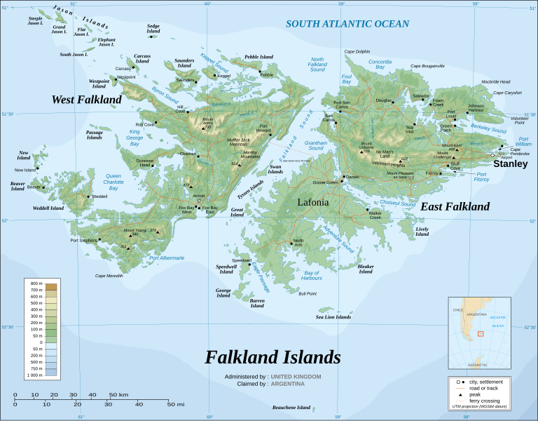
English: The Falkland Islands are an archipelago in the South Atlantic Ocean, located 300 miles off the coast of Argentina. They consist of two main islands, East Falkland and West Falkland, together with about 700 smaller islands. Stanley, on East Falkland, is the capital and largest city. The islands are a self-governing Overseas Territory of the United Kingdom.
Français : Carte topographique en anglais des Îles Malouines. Les Malouines forment un archipel dans l'Océan Atlantique Sud à 480 km des côtes argentines. Il est composé de deux îles principales, East Falkland et West Falkland, et de 700 autres îles et îlots. Stanley, sur East Falkland, est la capitale et la plus grande agglomération de l'archipel. Les Malouines sont un territoire autonome du Royaume-Uni.
Nederlands: Topografische kaart van de Falklandeilanden, een Brits overzees gebiedsdeel in de Zuidelijke Atlantische Oceaan. De archipel bestaat uit twee hoofdeilanden en ongeveer 700 kleinere op ongeveer 300 kilometer uit de kust van Argentinië. Stanley op het eiland 'East Falkland' is de hoofdstad en tergelijkertijd de meest bevolkte gemeente van het eilandengroep.De eilanden zijn een 'self-governing Overseas Territory' van het Verenigd Koninkrijk van Groot-Brittannië en Noord-Ierland.
Português: Mapa topográfico (em inglês) das Ilhas Malvinas, um arquipélago no sul do Oceano Atlântico, a 300 milhas da costa da Argentina. Consiste de duas ilhas, Soledad a leste e Gran Malvina, a oeste, junto com cerca de 700 outras ilhotas. A capital (e maior cidade) é Stanley. As Malvinas são um território autónomo do Reino Unido.
SVG genesis
InfoField
 
ซอร์สโค้ดของ SVG นี้ตรวจสอบถูกต้องแล้ว
 
ไฟล์ภาพกราฟิกส์เวกเตอร์นี้ สร้างขึ้นโดยใช้ Inkscape
{| cellspacing="8" cellpadding="0" style="clear:both; width:100%; margin:0.5em auto; border:2px solid #88A; background-color:#F7F8FF;" lang="th" dir="ltr"

|align="center"|แปลไฟล์นี้

|width="100%"|

ไฟล์ SVG นี้มีข้อความที่สามารถแปลได้ โดยใช้เครื่องมือแปบภาษา SVG หรือใช้ตัวแก้ไข SVG ใดก็ได้ สำหรับข้อมูลเพิ่มเติม ดูที่เกี่ยวกับการแปลไฟล์

|}
วันที่ November 2007 using elements from the original version of April 2007
แหล่งที่มา Own work ;
Topographic map : NASA Shuttle Radar Topography Mission (SRTM3 v.2) (public domain) edited with dlgv32 Pro/Global Mapper and vectorized with Inkscape ; UTM projection ; WGS84 datum ; shaded relief (composite image of N-W, W and N lightning positions) ;
Approximate scale of topographic data and shore / lakes limits : 1:705,000 ; of the bathymetry : 1:3.720.000
Bathymetry : USGov public domain data provided by the Demis add-on for World Wind (see the approval e-mail) ;
Other references used for additional data :
* UK government map ;
* NASA World Wind ;
* CIA map available on the site of the University of Texas at Austin ;
* Microsoft Encarta atlas (1999 edition).
Note : The shaded relief is a raster image embedded in the SVG file which increases its size. If you want a lighter map for other purposes, delete the shaded relief image in your file.
ผู้สร้าง
Eric Gaba (Sting - fr:Sting)
การอนุญาต
(การใช้ไฟล์นี้ใหม่)
Attribution and Share-Alike required
พิกัดอ้างอิงทางภูมิศาสตร์ ระบุพิกัดบนแผนที่ Wikimaps Warper ถ้ามีความไม่เหมาะสม กรุณาตั้ง warp_status = skip เพื่อซ่อน
เวอร์ชันอื่น

ไฟล์อื่นที่ใช้ไฟล์นี้:

[แก้ไข]


การอนุญาตใช้สิทธิ

ข้าพเจ้า ในฐานะผู้ถือลิขสิทธิ์ของภาพหรือสื่อนี้ อนุญาตให้ใช้ภาพหรือสื่อนี้ภายใต้เงื่อนไขต่อไปนี้
GNU head อนุญาตให้คัดลอก แจกจ่ายและ/หรือดัดแปรเอกสารนี้ภายใต้เงื่อนไขของสัญญาอนุญาตเอกสารเสรีของกนู รุ่น 1.2 หรือรุ่นใด ๆ นับจากนี้ที่ออกโดยมูลนิธิซอฟต์แวร์เสรี โดยไม่มีส่วนใดห้ามแก้ไข ไม่มีข้อความปกหน้าและปกหลัง สำเนาของสัญญาอนุญาตรวมอยู่ในส่วนชื่อ สัญญาอนุญาตเอกสารเสรีของกนู
w:th:ครีเอทีฟคอมมอนส์
แสดงที่มา อนุญาตแบบเดียวกัน
ไฟล์นี้อยู่ภายใต้สัญญาอนุญาต ครีเอทีฟคอมมอนส์ แบบแสดงที่มา-อนุญาตแบบเดียวกัน 3.0 ต้นฉบับ
คุณสามารถ:
  • ที่จะแบ่งปัน – ที่จะทำสำเนา แจกจ่าย และส่งงานดังกล่าวต่อไป
  • ที่จะเรียบเรียงใหม่ – ที่จะดัดแปลงงานดังกล่าว
ภายใต้เงื่อนไขต่อไปนี้:
  • แสดงที่มา – คุณต้องให้เกียรติเจ้าของงานอย่างเหมาะสม โดยเพิ่มลิงก์ไปยังสัญญาอนุญาต และระบุหากมีการเปลี่ยนแปลง คุณอาจทำเช่นนี้ได้ในรูปแบบใดก็ได้ตามควร แต่ต้องไม่ใช่ในลักษณะที่แนะว่าผู้ให้อนุญาตสนับสนุนคุณหรือการใช้งานของคุณ
  • อนุญาตแบบเดียวกัน – หากคุณดัดแปลง เปลี่ยนรูป หรือต่อเติมงานนี้ คุณต้องใช้สัญญาอนุญาตแบบเดียวกันหรือแบบที่เหมือนกับสัญญาอนุญาตที่ใช้กับงานนี้เท่านั้น
ป้ายแสดงสถานะลิขสิทธิ์นี้ถูกเพิ่มเพื่อให้เป็นไปตามการเปลี่ยนแปลงสัญญาอนุญาตของมูลนิธิวิกิมีเดีย จาก GFDL ไปยัง GFDL ควบคู่กับ CC-BY-SA 3.0
w:th:ครีเอทีฟคอมมอนส์
แสดงที่มา อนุญาตแบบเดียวกัน
ไฟล์นี้อยู่ภายใต้สัญญาอนุญาตครีเอทีฟคอมมอนส์ รุ่นแสดงที่มา-อนุญาตแบบเดียวกัน 2.5 ทั่วไป, 2.0 ทั่วไป และ 1.0 ทั่วไป
คุณสามารถ:
  • ที่จะแบ่งปัน – ที่จะทำสำเนา แจกจ่าย และส่งงานดังกล่าวต่อไป
  • ที่จะเรียบเรียงใหม่ – ที่จะดัดแปลงงานดังกล่าว
ภายใต้เงื่อนไขต่อไปนี้:
  • แสดงที่มา – คุณต้องให้เกียรติเจ้าของงานอย่างเหมาะสม โดยเพิ่มลิงก์ไปยังสัญญาอนุญาต และระบุหากมีการเปลี่ยนแปลง คุณอาจทำเช่นนี้ได้ในรูปแบบใดก็ได้ตามควร แต่ต้องไม่ใช่ในลักษณะที่แนะว่าผู้ให้อนุญาตสนับสนุนคุณหรือการใช้งานของคุณ
  • อนุญาตแบบเดียวกัน – หากคุณดัดแปลง เปลี่ยนรูป หรือต่อเติมงานนี้ คุณต้องใช้สัญญาอนุญาตแบบเดียวกันหรือแบบที่เหมือนกับสัญญาอนุญาตที่ใช้กับงานนี้เท่านั้น
คุณสามารถเลือกสัญญาอนุญาตดังกล่าวตามต้องการ

คำบรรยายโดยย่อ

เพิ่มคำบรรยายทรรทัดเดียวเพื่อขยายความว่าไฟล์นี้มีอะไร

ไอเทมที่แสดงอยู่ในไฟล์นี้

ประกอบด้วย

Commons quality assessment อังกฤษ

media type อังกฤษ

image/svg+xml

ประวัติไฟล์

คลิกวันที่/เวลาเพื่อดูไฟล์ที่ปรากฏในขณะนั้น

(ล่าสุด | เก่าสุด) ดู (ใหม่กว่า 10 | ) (10 | 20 | 50 | 100 | 250 | 500)
วันที่/เวลารูปย่อขนาดผู้ใช้ความเห็น
ปัจจุบัน09:51, 23 สิงหาคม 2564รูปย่อสำหรับรุ่นเมื่อ 09:51, 23 สิงหาคม 25642,550 × 1,990 (1.97 เมกะไบต์)Praça de MaioFile uploaded using svgtranslate tool (https://svgtranslate.toolforge.org/). Added translation for tr.
09:50, 23 สิงหาคม 2564รูปย่อสำหรับรุ่นเมื่อ 09:50, 23 สิงหาคม 25642,550 × 1,990 (1.97 เมกะไบต์)Praça de MaioFile uploaded using svgtranslate tool (https://svgtranslate.toolforge.org/). Added translation for tr.
18:54, 6 เมษายน 2560รูปย่อสำหรับรุ่นเมื่อ 18:54, 6 เมษายน 25602,550 × 1,990 (1.91 เมกะไบต์)RaviC+ New Haven Ferry
01:38, 20 ธันวาคม 2551รูปย่อสำหรับรุ่นเมื่อ 01:38, 20 ธันวาคม 25512,550 × 1,990 (1.93 เมกะไบต์)StingReverted to version as of 03:38, 14 November 2007: please upload the translated version under a specific name
01:26, 20 ธันวาคม 2551รูปย่อสำหรับรุ่นเมื่อ 01:26, 20 ธันวาคม 25512,550 × 1,990 (1.93 เมกะไบต์)Vitekthis is just croatian translation
10:38, 14 พฤศจิกายน 2550รูปย่อสำหรับรุ่นเมื่อ 10:38, 14 พฤศจิกายน 25502,550 × 1,990 (1.93 เมกะไบต์)StingNew version more accurate and with shaded relief
08:18, 16 มิถุนายน 2550รูปย่อสำหรับรุ่นเมื่อ 08:18, 16 มิถุนายน 25502,550 × 1,990 (1.03 เมกะไบต์)StingReverted to earlier revision
08:03, 16 มิถุนายน 2550รูปย่อสำหรับรุ่นเมื่อ 08:03, 16 มิถุนายน 25502,550 × 1,990 (2.14 เมกะไบต์)StingTrying to fix the bug on WP-en #8
07:40, 16 มิถุนายน 2550รูปย่อสำหรับรุ่นเมื่อ 07:40, 16 มิถุนายน 25502,550 × 1,990 (2.01 เมกะไบต์)StingTrying to fix the bug on WP-en #7 (really boring...)
07:29, 16 มิถุนายน 2550รูปย่อสำหรับรุ่นเมื่อ 07:29, 16 มิถุนายน 25502,550 × 1,990 (2.08 เมกะไบต์)StingTrying to fix the bug on WP-en #6 (OK, the problem comes from the shaded relief raster image)
(ล่าสุด | เก่าสุด) ดู (ใหม่กว่า 10 | ) (10 | 20 | 50 | 100 | 250 | 500)

หน้าต่อไปนี้ โยงมาที่ภาพนี้:

การใช้ไฟล์ข้ามโครงการ

วิกิอื่นต่อไปนี้ใช้ไฟล์นี้:

ดูการใช้ข้ามโครงการเพิ่มเติมของไฟล์นี้

ข้อมูลเกี่ยวกับภาพ