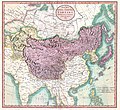
ไฟล์:1806 Cary Map of Tartary or Central Asia - Geographicus - Tartary-cary-1806.jpg

ไม่รองรับเนื้อหาของหน้าในภาษาอื่น
จากวิกิพีเดีย สารานุกรมเสรี

ดูภาพที่มีความละเอียดสูงกว่า(5,000 × 4,569 พิกเซล, ขนาดไฟล์: 8.57 เมกะไบต์, ชนิดไมม์: image/jpeg)

Wikimedia Commons logo รูปภาพหรือไฟล์เสียงนี้ ต้นฉบับอยู่ที่ คอมมอนส์ รายละเอียดด้านล่าง เป็นข้อความที่แสดงผลจาก ไฟล์ต้นฉบับในคอมมอนส์
คอมมอนส์เป็นเว็บไซต์ในโครงการสำหรับเก็บรวบรวมสื่อเสรี ที่ คุณสามารถช่วยได้
John Cary: A New Map of Mongolian & Independent Tartary , From the Latest Authorities.   (Wikidata search (Cirrus search) Wikidata query (SPARQL)  Create new Wikidata item based on this file)
ศิลปิน/ผู้สร้างสรรค์งาน
John Cary  (–1835)  wikidata:Q3446124 s:en:Author:John Cary
 
ชื่ออื่น
J. Cary
คำอธิบาย cartographer, engraver, mapseller, printseller และ graphic artist
วันเกิด/วันเสียชีวิต 23 กุมภาพันธ์ พ.ศ. 2298 / 2296 หรือ 2297 แก้ไขที่วิกิสนเทศ 16 สิงหาคม พ.ศ. 2378 แก้ไขที่วิกิสนเทศ
สถานที่เกิด/สถานที่เสียชีวิต Corsley Mortlake
ระยะเวลาสร้างสรรค์งาน 2330 หรือ 2331 / 2335 หรือ 2336 / 2339 หรือ 2340 แก้ไขที่วิกิสนเทศ
สถานที่สร้างสรรค์งาน
งานควบคุมรายการหลักฐาน
artist QS:P170,Q3446124
ชื่อเรื่อง
A New Map of Mongolian & Independent Tartary , From the Latest Authorities.
คำอธิบาย
English: An exceptionally beautiful example of John Cary’s important 1806 map of Mongolian and Independent Tartary. Covers Central Asia from the Caspian Sea to Japan, extends as far north as the Obskaia Sea and as far south as India, Burma and the Philippines. Includes the modern day nations of Uzbekistan, Kazakhstan, Turkmenistan, Kirgizstan, Tajikistan and Mongolia. One of Cary’s most interesting maps. Central Asia, despite hundreds of years of passing trade on the Silk Routes, was still, at the turn of the century a largely unknown land. Cary attempts to show some of the Silk Route passages, especially to the north of the Gobi, but ultimately admits, “The Geography of these parts is extremely obscure.” All in all, one of the most interesting and few maps of Central Asia to appear in first years of the 19th century. Prepared in 1806 by John Cary for issue in his magnificent 1808 New Universal Atlas. (NOTE: The reproduction of the colors in this map appear to be incorrect, as Japan and Tibet were never part of Chinese Tartary yet appear to be the same color as it.)
วันที่ 2348 หรือ 2349 (dated)
ขนาด ความสูง: ๑๘.๕ in (๔๖.๙ cm); ความกว้าง: ๒๐.๐ in (๕๐.๘ cm)
dimensions QS:P2048,18.5U218593
dimensions QS:P2049,20U218593
รหัสการถึอครอง
Geographicus link: Tartary-cary-1806
ที่มา/ผู้ถ่ายภาพ

Cary, John, Cary's New Universal Atlas, containing distinct maps of all the principal states and kingdoms throughout the World. From the latest and best authorities extant. London: Printed for J. Cary, Engraver and Map-seller, No. 181, near Norfolk Street, Strand, 1808.

การอนุญาต
(การใช้ไฟล์นี้ใหม่)
ภาพนี้เป็นภาพที่เกิดจากการทำสำเนาภาพหรือศิลปกรรมสองมิติ ซึ่งตัวภาพต้นฉบับที่ถูกทำซ้ำนั้นเป็นสาธารณสมบัติด้วยเหตุผลต่อไปนี้
Public domain

งานนี้เป็นสาธารณสมบัติ ในประเทศต้นกำเนิดและประเทศอื่น ๆ ที่ระยะเวลาการคุ้มครองลิขสิทธิ์น้อยกว่า 100 ปีหลังจากผู้สร้างสรรค์งานเสียชีวิต.


นอกจากนี้คุณอาจต้องเพิ่มป้ายสาธารณสมบัติในสหรัฐอเมริกา เพื่อระบุว่าเหตุใดงานนี้จึงเป็นสาธารณสมบัติในสหรัฐอเมริกา
มูลนิธิวิกิพีเดียมีมุมมองอย่างเป็นทางการในกรณีนี้ว่า "การทำสำเนาภาพหรือศิลปกรรมสองมิติที่เป็นสาธารณสมบัติ ถือว่าภาพที่ได้จากการทำสำเนาเป็นสาธารณสมบัติ การอ้างผลงานดังกล่าวเป็นงานส่วนบุคคลเป็นการขัดต่อแนวคิดเกี่ยวกับสาธารณสมบัติ" สำหรับข้อมูลเพิ่มเติม ดูที่ เมื่อใดจะใช้ป้าย PD-Art
การทำสำเนาของภาพนี้ซึ่งเป็นสาธารณสมบัติ ถือได้ว่าภาพที่เกิดจากการทำสำเนาเป็นสาธารณสมบัติเช่นกัน โปรดทราบว่าการนำภาพนี้ไปใช้อาจถูกจำกัดหรือห้ามใช้ในเขตอำนาจศาลของท่าน ทั้งนี้ขึ้นกับกฎหมายท้องถิ่นที่บังคับใช้ในพื้นที่นั้น ๆ ดูเพิ่มที่ การนำภาพหรือศิลปกรรมสองมิติไปใช้
เวอร์ชันอื่น
Annotations
InfoField
This image is annotated: View the annotations at Commons

คำบรรยายโดยย่อ

เพิ่มคำบรรยายทรรทัดเดียวเพื่อขยายความว่าไฟล์นี้มีอะไร

ไอเทมที่แสดงอยู่ในไฟล์นี้

ประกอบด้วย

media type อังกฤษ

image/jpeg

checksum อังกฤษ

3d7f1be3ae7a9539d26d91394bee37e7dc951779

data size อังกฤษ

8,990,511 ไบต์

4,569 พิกเซล

5,000 พิกเซล

ประวัติไฟล์

คลิกวันที่/เวลาเพื่อดูไฟล์ที่ปรากฏในขณะนั้น

วันที่/เวลารูปย่อขนาดผู้ใช้ความเห็น
ปัจจุบัน15:56, 19 สิงหาคม 2562รูปย่อสำหรับรุ่นเมื่อ 15:56, 19 สิงหาคม 25625,000 × 4,569 (8.57 เมกะไบต์)SoerfmBrightness, color
17:56, 22 มีนาคม 2554รูปย่อสำหรับรุ่นเมื่อ 17:56, 22 มีนาคม 25545,000 × 4,569 (7.81 เมกะไบต์)BotMultichillT{{subst:User:Multichill/Geographicus |link=http://www.geographicus.com/P/AntiqueMap/Tartary-cary-1806 |product_name=1806 Cary Map of Tartary or Central Asia |map_title=A New Map of Chinese & Independent Tartary , From the Latest Authorities. |description=

ไม่มีหน้าใดโยงมาที่ภาพนี้

การใช้ไฟล์ข้ามโครงการ

วิกิอื่นต่อไปนี้ใช้ไฟล์นี้:

ข้อมูลเกี่ยวกับภาพ