จากวิกิพีเดีย สารานุกรมเสรี
ความย่อ
Map
Ceremonial county
Shire county / unitary
Districts
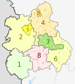
1. Herefordshire U.A.
Shropshire 2. Shropshire U.A.
3. Telford and Wrekin U.A.
Staffordshire 4. Staffordshire †
a ) Cannock Chase , b ) East Staffordshire , c ) Lichfield , d ) Newcastle-under-Lyme , e ) South Staffordshire , f ) Stafford , g ) Staffordshire Moorlands , h ) Tamworth
5. Stoke-on-Trent U.A.
6. Warwickshire †
a ) North Warwickshire , b ) Nuneaton and Bedworth , c ) Rugby , d ) Stratford-on-Avon , e ) Warwick
7. West Midlands *
a ) Birmingham , b ) Coventry , c ) Dudley , d ) Sandwell , e ) Solihull , f ) Walsall , g ) Wolverhampton
8. Worcestershire †
a ) Bromsgrove , b ) Malvern Hills , c ) Redditch , d ) Worcester , e ) Wychavon , f ) Wyre Forest
Key: †shire county | *metropolitan county
การอนุญาตใช้สิทธิ การแสดงที่มา: Dr Greg and Nilfanion. Contains Ordnance Survey data © Crown copyright and database right 2011
คุณสามารถ:
ที่จะแบ่งปัน – ที่จะทำสำเนา แจกจ่าย และส่งงานดังกล่าวต่อไปที่จะเรียบเรียงใหม่ – ที่จะดัดแปลงงานดังกล่าว
ภายใต้เงื่อนไขต่อไปนี้:
แสดงที่มา – คุณต้องให้เกียรติเจ้าของงานอย่างเหมาะสม โดยเพิ่มลิงก์ไปยังสัญญาอนุญาต และระบุหากมีการเปลี่ยนแปลง คุณอาจทำเช่นนี้ได้ในรูปแบบใดก็ได้ตามควร แต่ต้องไม่ใช่ในลักษณะที่แนะว่าผู้ให้อนุญาตสนับสนุนคุณหรือการใช้งานของคุณอนุญาตแบบเดียวกัน – หากคุณดัดแปลง เปลี่ยนรูป หรือต่อเติมงานนี้ คุณต้องใช้สัญญาอนุญาตแบบเดียวกันหรือแบบที่เหมือนกับสัญญาอนุญาตที่ใช้กับงานนี้ เท่านั้น https://creativecommons.org/licenses/by-sa/3.0 CC BY-SA 3.0 Creative Commons Attribution-Share Alike 3.0 true true บันทึกการอัพโหลด This image is a derivative work of the following images:
File:West_Midlands_districts_2011_map.svg licensed with Cc-by-sa-3.0, GFDL
2011-05-01T19:06:46Z Nilfanion 1161x1306 (1392730 Bytes) == Summary == {{Information |Description=Map of the [[w:West Midlands|West Midlands]] region showing the administrative districts. Equirectangular map projection on WGS 84 datum, with N/S stretched 165% Geographic limits: * File:English_ceremonial_counties_2010.svg licensed with Cc-by-sa-3.0, GFDL
2010-11-23T16:39:55Z Nilfanion 1108x1345 (308868 Bytes) thicker lines
2010-11-23T16:20:19Z Nilfanion 1108x1345 (301520 Bytes) tweaks
2010-10-26T20:34:20Z Nilfanion 817x990 (1391832 Bytes) {{Information |Description=Map showing the [[w:ceremonial counties of England]] including the City of London, in 2010. Equirectangular map projection on WGS 84 datum, with N/S stretched 170% Geographic limits: *West: 6.75W Uploaded with derivativeFX
ไทย เพิ่มคำบรรยายทรรทัดเดียวเพื่อขยายความว่าไฟล์นี้มีอะไร
ประวัติไฟล์
คลิกวันที่/เวลาเพื่อดูไฟล์ที่ปรากฏในขณะนั้น
วันที่/เวลา รูปย่อ ขนาด ผู้ใช้ ความเห็น ปัจจุบัน 03:01, 6 พฤษภาคม 2555 1,161 × 1,306 (1.38 เมกะไบต์) Dr Greg lighten black boundary line 04:19, 3 พฤษภาคม 2555 1,161 × 1,306 (1.38 เมกะไบต์) Dr Greg == {{int:filedesc}} == {{Information |Description={{en|Map of the West Midlands region of England, showing its counties and administrative districts. The county colours are the same as those in [[:File:English metropolitan ...
หน้าที่มีภาพนี้
หน้าต่อไปนี้ โยงมาที่ภาพนี้:
การใช้ไฟล์ข้ามโครงการ
วิกิอื่นต่อไปนี้ใช้ไฟล์นี้:
การใช้บน ar.wikipedia.org
การใช้บน bar.wikipedia.org
การใช้บน de.wikipedia.org
การใช้บน en.wikipedia.org
การใช้บน fa.wikipedia.org
การใช้บน frr.wikipedia.org
การใช้บน fr.wikipedia.org
การใช้บน hr.wikipedia.org
การใช้บน hu.wikipedia.org
การใช้บน mr.wikipedia.org
การใช้บน pl.wikipedia.org
การใช้บน pnb.wikipedia.org
การใช้บน pt.wikipedia.org
การใช้บน tr.wikipedia.org
การใช้บน ur.wikipedia.org
การใช้บน vec.wikipedia.org
การใช้บน vi.wikipedia.org
การใช้บน vls.wikipedia.org
การใช้บน zh-yue.wikipedia.org


