
ไฟล์:Tokyo L7 lrg.jpg

ขนาดของตัวอย่างนี้: 600 × 600 พิกเซล ความละเอียดอื่น: 240 × 240 พิกเซล | 480 × 480 พิกเซล | 1,000 × 1,000 พิกเซล
ดูภาพที่มีความละเอียดสูงกว่า (1,000 × 1,000 พิกเซล, ขนาดไฟล์: 511 กิโลไบต์, ชนิดไมม์: image/jpeg)
| รูปภาพหรือไฟล์เสียงนี้ ต้นฉบับอยู่ที่ คอมมอนส์ รายละเอียดด้านล่าง เป็นข้อความที่แสดงผลจาก ไฟล์ต้นฉบับในคอมมอนส์
|
ความย่อ
| คำอธิบาย |
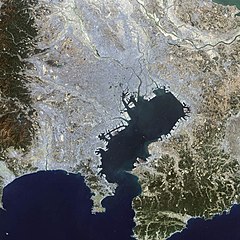
English: This false-color Landsat 7 image shows (a large part of) the greater Tokyo metropolitan area, situated on the eastern shore of the Japanese island of Honshu. The large Tokyo Bay dominates the center of this scene, and if you look closely you can see boats and their wakes on the water. The greater Tokyo area fans out in a crescent shape around the western, northern, and eastern shores of Tokyo Bay. Greater Tokyo is bordered to the west by rugged mountains and to the east by the vast expanse of the Pacific Ocean.
The greater metropolis area is comprised of Tokyo prefecture, situated on the northwestern shore of Tokyo Bay, and the three neighboring prefectures of Kanagawa to the south, Saitama to the north, and Chiba to the east and southeast across Tokyo Bay. Over the last 400 years, Japan’s National Capital Region has evolved into a large, self-governing unit consisting of 26 cities, 5 towns, and 8 villages. The region is home to some 38 million people in 2018 (more than a quarter of Japan’s whole population) in a metropolitan area spanning 14,034 square km. 日本語: 東京湾の衛星画像(2002年)人工衛星「NASA Earth Observatory」による。 |
| วันที่ | |
| แหล่งที่มา | Earth Observatory |
| ผู้สร้างสรรค์ | Image courtesy Ron Beck, USGS Eros Data Center Satellite Systems Branch |
การอนุญาตใช้สิทธิ
| ภาพนี้เป็นสาธารณสมบัติ เนื่องจากเป็นภาพที่สร้างขึ้นโดยองค์การบริหารการบินและอวกาศแห่งชาติ (NASA) ซึ่งตามนโยบายด้านลิขสิทธิ์ของนาซาระบุไว้ว่า "ภาพและสื่อต่าง ๆ ของนาซาไม่ได้รับการคุ้มครองโดยลิขสิทธิ์ยกเว้นจะระบุไว้ว่ามีลิขสิทธิ์" ดูเพิ่มที่ หน้านโยบายด้านลิขสิทธิ์ของนาซา หรือ นโยบายการใช้ภาพของ JPL | ||
 |
คำเตือน:
|
ประวัติไฟล์
คลิกวันที่/เวลาเพื่อดูไฟล์ที่ปรากฏในขณะนั้น
| วันที่/เวลา | รูปย่อ | ขนาด | ผู้ใช้ | ความเห็น | |
|---|---|---|---|---|---|
| ปัจจุบัน | 21:25, 18 พฤศจิกายน 2551 | | 1,000 × 1,000 (511 กิโลไบต์) | Jyusin | {{Information |Description={{en|1=Tokyo}} {{ja|1=東京}} |Source=[http://earthobservatory.nasa.gov/IOTD/view.php?id=2854 Earth Observatory] |Author=NASA |Date= |Permission= |other_versions= }} <!--{{ImageUpload|full}}--> |
หน้าที่มีภาพนี้
ไม่มีหน้าใดโยงมาที่ภาพนี้
การใช้ไฟล์ข้ามโครงการ
วิกิอื่นต่อไปนี้ใช้ไฟล์นี้:
- การใช้บน az.wikipedia.org
- การใช้บน de.wikipedia.org
- การใช้บน es.wikipedia.org
- การใช้บน fr.wikipedia.org
- การใช้บน hu.wikipedia.org
- การใช้บน it.wikipedia.org
- การใช้บน ja.wikipedia.org
- การใช้บน pt.wikipedia.org
- การใช้บน simple.wikipedia.org
- การใช้บน tr.wikipedia.org
- การใช้บน vi.wikipedia.org
- การใช้บน zh.wikipedia.org