
ไฟล์:The Man in the High Castle Plausible World Map.png
ขนาดของตัวอย่างนี้: 800 × 579 พิกเซล ความละเอียดอื่น: 320 × 232 พิกเซล | 640 × 463 พิกเซล | 1,024 × 741 พิกเซล | 1,280 × 926 พิกเซล | 1,577 × 1,141 พิกเซล
ดูภาพที่มีความละเอียดสูงกว่า (1,577 × 1,141 พิกเซล, ขนาดไฟล์: 400 กิโลไบต์, ชนิดไมม์: image/png)
| รูปภาพหรือไฟล์เสียงนี้ ต้นฉบับอยู่ที่ คอมมอนส์ รายละเอียดด้านล่าง เป็นข้อความที่แสดงผลจาก ไฟล์ต้นฉบับในคอมมอนส์
|

|
This map, as well as other fictitious maps, is fictitious or too incorrect (i.e. due to anachronism) to be used in real-life contexts (contemporary or historic). It may have some visual elements that are similar to official maps such as colors or certain layout features, but they are NOT official and don't have any official recognition. |
[[Category:]]
ความย่อ
| คำอธิบาย |
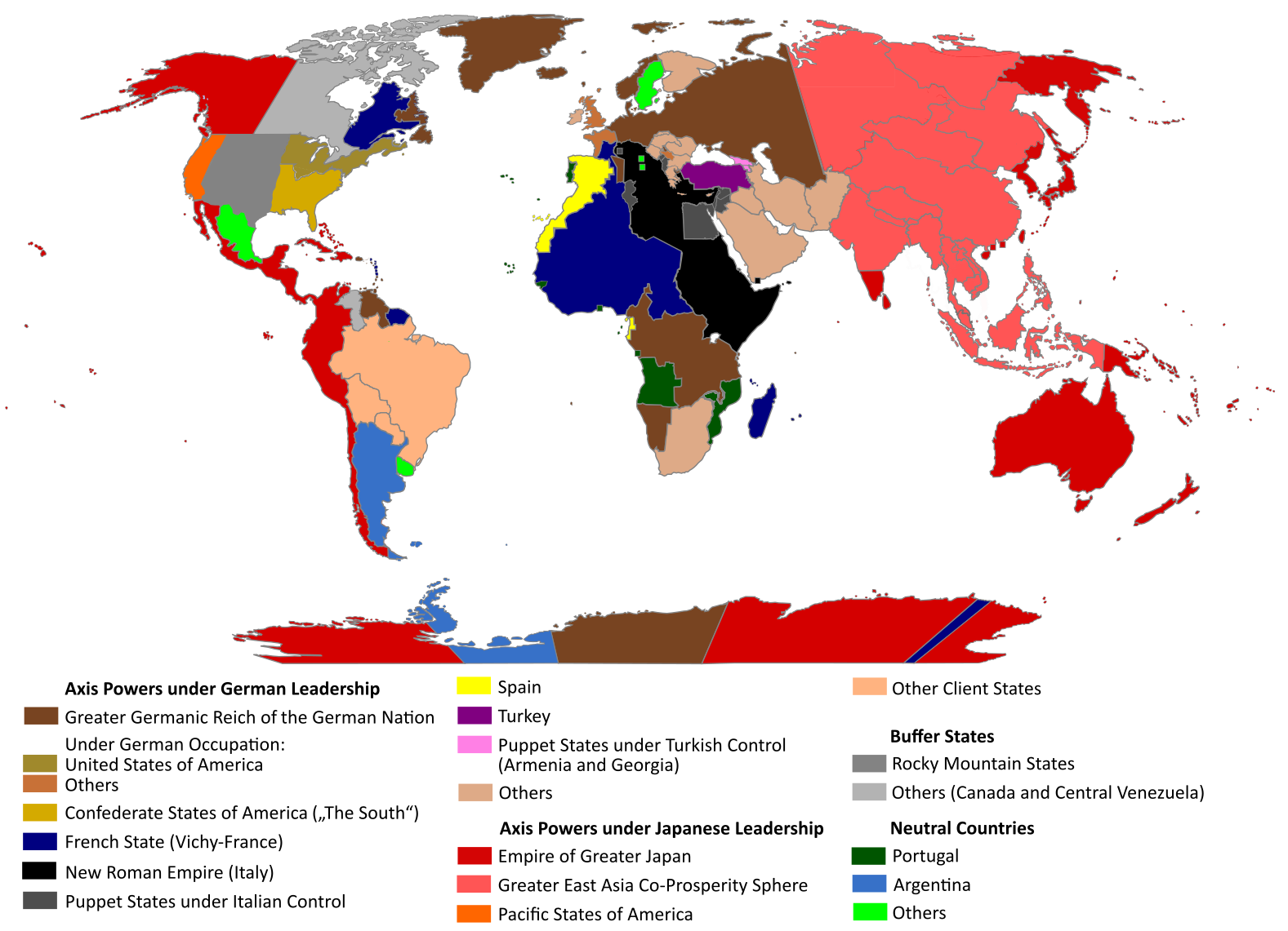
English: "The Man in the High Castle" is an alternate history novel by Philip K. Dick. It is set in a world in which the Axis powers have won World War II. This map is inspired by Dick's story and shows a plausible division of the world between Nazi Germany (dark brown), Imperial Japan (dark red) and their respective allies. However, the map is much more precise than the book describes.
https://web.archive.org/web/20191202005150/http://www.high-castle-world-map.com:80/ |
| วันที่ | |
| แหล่งที่มา | งานของตัว |
| ผู้สร้างสรรค์ | RobintheHighCastle |
| การอนุญาต (การใช้ไฟล์นี้ใหม่) |
การอนุญาตใช้สิทธิ
ข้าพเจ้า ในฐานะผู้ถือลิขสิทธิ์ของภาพหรือสื่อนี้ อนุญาตให้ใช้ภาพหรือสื่อนี้ภายใต้เงื่อนไขต่อไปนี้
ไฟล์นี้อยู่ภายใต้สัญญาอนุญาต ครีเอทีฟคอมมอนส์ แบบแสดงที่มา-อนุญาตแบบเดียวกัน 4.0 นานาชาติ
- คุณสามารถ:
- ที่จะแบ่งปัน – ที่จะทำสำเนา แจกจ่าย และส่งงานดังกล่าวต่อไป
- ที่จะเรียบเรียงใหม่ – ที่จะดัดแปลงงานดังกล่าว
- ภายใต้เงื่อนไขต่อไปนี้:
- แสดงที่มา – คุณต้องให้เกียรติเจ้าของงานอย่างเหมาะสม โดยเพิ่มลิงก์ไปยังสัญญาอนุญาต และระบุหากมีการเปลี่ยนแปลง คุณอาจทำเช่นนี้ได้ในรูปแบบใดก็ได้ตามควร แต่ต้องไม่ใช่ในลักษณะที่แนะว่าผู้ให้อนุญาตสนับสนุนคุณหรือการใช้งานของคุณ
- อนุญาตแบบเดียวกัน – หากคุณดัดแปลง เปลี่ยนรูป หรือต่อเติมงานนี้ คุณต้องใช้สัญญาอนุญาตแบบเดียวกันหรือแบบที่เหมือนกับสัญญาอนุญาตที่ใช้กับงานนี้เท่านั้น
ประวัติไฟล์
คลิกวันที่/เวลาเพื่อดูไฟล์ที่ปรากฏในขณะนั้น
| วันที่/เวลา | รูปย่อ | ขนาด | ผู้ใช้ | ความเห็น | |
|---|---|---|---|---|---|
| ปัจจุบัน | 21:55, 29 ตุลาคม 2564 | | 1,577 × 1,141 (400 กิโลไบต์) | Saltner67 | Added the portoguese colonies Cabinda and Ajuda since they would still have existed in this world. |
| 15:05, 20 มิถุนายน 2564 |  | 1,613 × 1,143 (417 กิโลไบต์) | Gernsback67 | Changed "Greater Asian Co-Prosperity Sphere" in "Greater East Asia Co-Prosperity Sphere", which is correct. | |
| 22:30, 16 ตุลาคม 2563 |  | 1,611 × 1,138 (418 กิโลไบต์) | Saltner67 | Restored the latest version. Please do not revert any changes, which have been made to this file so far, without any communication with the author of the map. All changes made here have been initialized by the author and are a result of the same process which has led to the creation of the map in the first place. | |
| 15:25, 16 ตุลาคม 2563 |  | 1,621 × 1,137 (392 กิโลไบต์) | Gooduserdude | RV Original research: this image is based on a source and should not be altered | |
| 21:15, 29 มีนาคม 2563 |  | 1,611 × 1,138 (418 กิโลไบต์) | Saltner67 | Improved the accuracy of borders of Mongolia and Manchukuo. | |
| 22:58, 27 มีนาคม 2563 |  | 1,607 × 1,138 (418 กิโลไบต์) | Saltner67 | Enlarged Manchukuo and added the puppet states of Yakutia and Krasnoyarsk/Irkutsk after more research on Kantokuen. | |
| 02:07, 13 มีนาคม 2563 |  | 1,612 × 1,143 (411 กิโลไบต์) | Saltner67 | Moved the Swiss Canton of Valais from Germany to Italy, as has been prepared in the plans for Operation Tannenbaum. | |
| 01:57, 9 กุมภาพันธ์ 2563 |  | 1,605 × 1,139 (411 กิโลไบต์) | Saltner67 | Reinserted the territories of Tunisia,Greece, Crete and Cyprus after research on the Italian plannings and Greece in WWII. | |
| 20:21, 21 พฤศจิกายน 2562 |  | 1,611 × 1,133 (409 กิโลไบต์) | Gernsback67 | Enlarged Mongolia again after more research on pan-mongolism. | |
| 22:13, 21 กันยายน 2562 |  | 1,610 × 1,137 (408 กิโลไบต์) | Saltner67 | unified Mongolia, enlarged Manchukuo and Thailand, re-inserted the real-life borders of Laos and Vietnam after research on Demchugdongrub, Kantokuen, Thailand and Indochina in WWII |
หน้าที่มีภาพนี้
หน้าต่อไปนี้ โยงมาที่ภาพนี้:
การใช้ไฟล์ข้ามโครงการ
วิกิอื่นต่อไปนี้ใช้ไฟล์นี้:
- การใช้บน ar.wikipedia.org
- การใช้บน cs.wikipedia.org
- การใช้บน da.wikipedia.org
- การใช้บน de.wikipedia.org
- การใช้บน en.wikipedia.org
- การใช้บน en.wikiquote.org
- การใช้บน es.wikipedia.org
- การใช้บน gl.wikipedia.org
- การใช้บน he.wikipedia.org
- การใช้บน hu.wikipedia.org
- การใช้บน it.wikipedia.org
- การใช้บน ja.wikipedia.org
- การใช้บน ko.wikipedia.org
- การใช้บน lt.wikipedia.org
- การใช้บน nl.wikipedia.org
- การใช้บน pl.wikipedia.org
- การใช้บน pt.wikipedia.org
- การใช้บน ro.wikipedia.org
- การใช้บน ru.wikipedia.org
- การใช้บน uk.wikipedia.org
- การใช้บน zh-classical.wikipedia.org
- การใช้บน zh.wikipedia.org