
ไฟล์:Stad Amsterdam in Nieuw Nederland (City Amsterdam in New Netherland) Castello Plan 1660.jpg

ขนาดของตัวอย่างนี้: 800 × 600 พิกเซล ความละเอียดอื่น: 320 × 240 พิกเซล | 640 × 480 พิกเซล | 1,024 × 768 พิกเซล | 1,280 × 960 พิกเซล | 2,560 × 1,920 พิกเซล | 3,888 × 2,916 พิกเซล
ดูภาพที่มีความละเอียดสูงกว่า (3,888 × 2,916 พิกเซล, ขนาดไฟล์: 4.28 เมกะไบต์, ชนิดไมม์: image/jpeg)
| รูปภาพหรือไฟล์เสียงนี้ ต้นฉบับอยู่ที่ คอมมอนส์ รายละเอียดด้านล่าง เป็นข้อความที่แสดงผลจาก ไฟล์ต้นฉบับในคอมมอนส์
|
_Castello_Plan_1660.jpg)
ความย่อ
| คำอธิบาย |
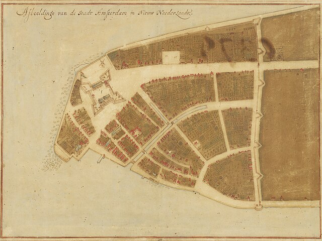
English: Map of New Amsterdam in New Netherland (Manhattan), 1660. Title: "Afbeeldinge van de Stadt Amsterdam in Nieuw Neederlandt." Made by Johannes Vingboons (1616-1670), a cartographer of the VOC. Based on surveys by Jacques Cortelyou (1625–1693). The Grand Duke of Tuscany, Cosimo III de’ Medici (1642-1723), travelled to Amsterdam, the Netherlands in 1667. He was fascinated by Vingboons' work and bought watercolor paintings with mediation by Pieter Blaeu (1637-1706). The paintings were exhibited in his Florentine Villa di Castello.[1] |
| วันที่ | |
| แหล่งที่มา | New York Historical Society - https://www.nyhistory.org/exhibitions/new-york-before-new-york-the-castello-plan . Image url: https://web.archive.org/web/20240212181141/https://images.prismic.io/nyhs-prod/3016cf7a-44f1-484c-9de7-53facb6ab21a_Carte+di+Castello+18.jpg The map (Carte di Castello 18) is at Biblioteca Medicea Laurenziana, Florence. |
| ผู้สร้างสรรค์ | Johannes Vingboons (cartographer), Jacques Cortelyou (surveyor) |
| เวอร์ชันอื่น |
 |
การอนุญาตใช้สิทธิ
|
งานนี้เป็นสาธารณสมบัติ ในประเทศต้นกำเนิดและประเทศอื่น ๆ ที่ระยะเวลาการคุ้มครองลิขสิทธิ์น้อยกว่า 100 ปีหลังจากผู้สร้างสรรค์งานเสียชีวิต. | |
| ไฟล์นี้ได้ถูกระบุว่าไม่มีข้อจำกัดภายใต้กฎหมายลิขสิทธิ์ รวมถึงสิทธิที่เกี่ยวข้องและที่ใกล้เคียงกัน | |
- ↑ De ontdekking van de wereld. University of Groningen Library (October 2, 2019). Archived from the original on June 29, 2022.
ประวัติไฟล์
คลิกวันที่/เวลาเพื่อดูไฟล์ที่ปรากฏในขณะนั้น
| วันที่/เวลา | รูปย่อ | ขนาด | ผู้ใช้ | ความเห็น | |
|---|---|---|---|---|---|
| ปัจจุบัน | 10:34, 13 เมษายน 2567 | | 3,888 × 2,916 (4.28 เมกะไบต์) | User-duck | Cropped borders to center using CropTool with lossless mode. |
| 01:52, 13 กุมภาพันธ์ 2567 |  | 4,000 × 3,070 (4.54 เมกะไบต์) | Artanisen | Corrected brightness and contrast | |
| 23:59, 12 กุมภาพันธ์ 2567 |  | 4,000 × 3,070 (4.2 เมกะไบต์) | Artanisen | Uploaded a work by Johannes Vingboons (VOC-cartographer), Jacques Cortelyou (surveyor) from New York Historical Society - https://www.nyhistory.org/exhibitions/new-york-before-new-york-the-castello-plan . Image url: https://images.prismic.io/nyhs-prod/3016cf7a-44f1-484c-9de7-53facb6ab21a_Carte+di+Castello+18.jpg with UploadWizard |
หน้าที่มีภาพนี้
หน้าต่อไปนี้ โยงมาที่ภาพนี้:
การใช้ไฟล์ข้ามโครงการ
วิกิอื่นต่อไปนี้ใช้ไฟล์นี้:
- การใช้บน arz.wikipedia.org
- การใช้บน de.wikipedia.org
- การใช้บน en.wikipedia.org
- New Amsterdam
- Peter Stuyvesant
- Wall Street
- Manhattan
- Financial District, Manhattan
- New York City
- Whitehall Street
- List of cities with defensive walls
- Castello Plan
- Jacques Cortelyou
- List of coastal fortifications of the United States
- New Netherland settlements
- Jan Everts Bout
- Harbor Defenses of New York
- Manhattoe
- Cartography of New York City
- History of Manhattan
- การใช้บน en.wikivoyage.org
- การใช้บน es.wikipedia.org
- การใช้บน fi.wikipedia.org
- การใช้บน fr.wikipedia.org
- การใช้บน gu.wikipedia.org
- การใช้บน gv.wikipedia.org
- การใช้บน he.wikipedia.org
- การใช้บน hi.wikipedia.org
- การใช้บน hu.wikipedia.org
- การใช้บน hy.wikipedia.org
- การใช้บน id.wikipedia.org
- การใช้บน it.wikipedia.org
- การใช้บน ja.wikipedia.org
- การใช้บน kn.wikipedia.org
ดูการใช้ข้ามโครงการเพิ่มเติมของไฟล์นี้
_Castello_Plan_1660.jpg)
_Castello_Plan_1660.jpg)