
ไฟล์:Spanish Empire.png
ดูภาพที่มีความละเอียดสูงกว่า (1,357 × 628 พิกเซล, ขนาดไฟล์: 38 กิโลไบต์, ชนิดไมม์: image/png)
| รูปภาพหรือไฟล์เสียงนี้ ต้นฉบับอยู่ที่ คอมมอนส์ รายละเอียดด้านล่าง เป็นข้อความที่แสดงผลจาก ไฟล์ต้นฉบับในคอมมอนส์
|

== ความย่อ == sijn is kaulo koel en voeg zijn snap ( stijnsnoeck12)
| คำอธิบาย |
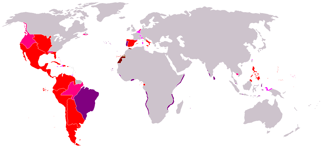
Map of the Spanish Empire from 295px. ความย่อRedThe Spanish Empire as it stood under the en:House of Bourbon, reaching its peak in the early 1790s. Includes the en:Viceroyalty of New Spain, en:Viceroyalty of Peru, en:Viceroyalty of La Plata, en:Viceroyalty of New Granada, en:Audiencia of Chile, en:Cuba, en:Puerto Rico, en:Santo Domingo, the Louisiana colony, the Nootka colony, the en:Philippines, the satellite en:Kingdom of Naples and en:Duchy of Parma, and various island groups. Louisiana and New Orleans, which were never widely settled, were returned to France in 1800, the Nootka colony was abandoned in 1795; Spain ceded its claims to the en:Mississippi Territory to the United States in 1795 and en:Florida in 1819; en:New Spain became an independent en:Mexico in 1821. Spanish settlement did not reach the south of Argentina and Chile until the early en:19th century. By 1824, all of Spain's South American colonies had become independent republics. British economic rights in present-day en:Belize were established in the 18th century. The colony of en:British Honduras was not created until 1841, after the end of Spanish rule in the region. Most of Central America became independent in 1823 as the en:United Provinces of Central America. Cuba was granted independence and Puerto Rico was ceded to the United States after the en:Spanish-American War. PinkRegions of Spanish influence over various periods; disputed (i.e. Pacific Coast), unrecognized (i.e. en:Dutch Republic), or short-lived claims (i.e. Cambodia).
LavenderTerritories lost at or before the en:Peace of Utrecht in 1714. Spain lost Jamaica to England in the 1650s and Haiti to France in the en:17th century. Many smaller islands in the en:Bahamas and the en:Lesser Antilles were also settled by other Europeans during this period. Spain's territories in present-day France, such as en:Rousillon and the en:Franche-Comté, were conquered Louis XIV. Spain was stripped of her remaining European dominions in 1714. Spain reconquered some of her lost Italian possessions from the Austrians in the 18th century, placing Bourbon princes on the thrones of Parma, Naples, and Sicily. However, these were not incorporated again into the Spanish Crown. PurplePortuguese possessions ruled jointly under the Spanish sovereign, 1580-1640. BrownSpain's en:West African empire, including en:Spanish West Africa and en:Spanish Morocco. |
| วันที่ | Commons upload by Kjetil r 10:47, 14 May 2006 (UTC) |
| แหล่งที่มา |
Originally from en.wikipedia; description page is (was) here
|
| ผู้สร้างสรรค์ | Users Albrecht, Arthur Wellesley, XGustaX on en.wikipedia |
| การอนุญาต (การใช้ไฟล์นี้ใหม่) |
GFDL |
การอนุญาตใช้สิทธิ

|
อนุญาตให้คัดลอก แจกจ่ายและ/หรือดัดแปรเอกสารนี้ภายใต้เงื่อนไขของสัญญาอนุญาตเอกสารเสรีของกนู รุ่น 1.2 หรือรุ่นใด ๆ นับจากนี้ที่ออกโดยมูลนิธิซอฟต์แวร์เสรี โดยไม่มีส่วนใดห้ามแก้ไข ไม่มีข้อความปกหน้าและปกหลัง สำเนาของสัญญาอนุญาตรวมอยู่ในส่วนชื่อ สัญญาอนุญาตเอกสารเสรีของกนู |
| ไฟล์นี้อยู่ภายใต้สัญญาอนุญาต ครีเอทีฟคอมมอนส์ แบบแสดงที่มา-อนุญาตแบบเดียวกัน 3.0 ต้นฉบับ | ||
| ||
| ป้ายแสดงสถานะลิขสิทธิ์นี้ถูกเพิ่มเพื่อให้เป็นไปตามการเปลี่ยนแปลงสัญญาอนุญาตของมูลนิธิวิกิมีเดีย จาก GFDL ไปยัง GFDL ควบคู่กับ CC-BY-SA 3.0 |
See also


ประวัติไฟล์
คลิกวันที่/เวลาเพื่อดูไฟล์ที่ปรากฏในขณะนั้น
| วันที่/เวลา | รูปย่อ | ขนาด | ผู้ใช้ | ความเห็น | |
|---|---|---|---|---|---|
| ปัจจุบัน | 02:37, 19 เมษายน 2551 | | 1,357 × 628 (38 กิโลไบต์) | Durero | Reverted to version as of 18:01, 16 April 2008 Talk |
| 01:58, 19 เมษายน 2551 |  | 1,357 × 628 (37 กิโลไบต์) | Patstuart | Reverted to version as of 01:45, 15 April 2008 - Portugal was never part of the Spanish empire | |
| 01:01, 17 เมษายน 2551 |  | 1,357 × 628 (38 กิโลไบต์) | Durero | Reverted to version as of 20:27, 14 January 2008 | |
| 08:45, 15 เมษายน 2551 |  | 1,357 × 628 (37 กิโลไบต์) | The Ogre | Correcting erros - the Portuguese empire was never a part of the Spanish empire | |
| 03:27, 15 มกราคม 2551 |  | 1,357 × 628 (38 กิโลไบต์) | Durero | I include Sabah | |
| 16:19, 28 กันยายน 2549 |  | 1,357 × 628 (38 กิโลไบต์) | Koika | The Spanish area in Taiwan is ony NOT correct. | |
| 17:48, 14 พฤษภาคม 2549 |  | 1,357 × 628 (38 กิโลไบต์) | Kjetil r | ||
| 03:12, 12 พฤษภาคม 2549 |  | 1,357 × 628 (38 กิโลไบต์) | Kjetil r | {{Information| |Description= == Summary == Map of the en:Spanish Empire from Image:BlankMap-World.png. ==Description== *Red: all claimed Spanish territories(1492-1975), shown together simultaneously and at their maximum extent. Actual contol and set |
หน้าที่มีภาพนี้
หน้าต่อไปนี้ โยงมาที่ภาพนี้:
การใช้ไฟล์ข้ามโครงการ
วิกิอื่นต่อไปนี้ใช้ไฟล์นี้:
- การใช้บน an.wikipedia.org
- การใช้บน ar.wikipedia.org
- การใช้บน ast.wikipedia.org
- การใช้บน cs.wikipedia.org
- การใช้บน da.wikipedia.org
- การใช้บน en.wikipedia.org
- การใช้บน es.wikipedia.org
- การใช้บน fr.wikipedia.org
- การใช้บน gl.wikipedia.org
- การใช้บน it.wikipedia.org
- การใช้บน ka.wikipedia.org
- การใช้บน sv.wikipedia.org
- การใช้บน zh.wikipedia.org