
ไฟล์:Significant tornado alley.gif
ไม่มีภาพที่มีรายละเอียดสูงกว่านี้
Significant_tornado_alley.gif (512 × 360 พิกเซล, ขนาดไฟล์: 8 กิโลไบต์, ชนิดไมม์: image/gif)
| รูปภาพหรือไฟล์เสียงนี้ ต้นฉบับอยู่ที่ คอมมอนส์ รายละเอียดด้านล่าง เป็นข้อความที่แสดงผลจาก ไฟล์ต้นฉบับในคอมมอนส์
|
ความย่อ
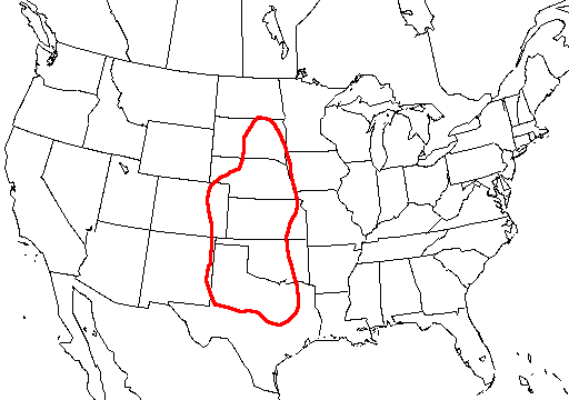
| คำอธิบาย |
English: A map of the united states with Tornado Alley outlined, here defined as the area where approximately 1 day or greater per decade was near (25 mi; 40 km) a significant (F2 or stronger) tornado. |
| แหล่งที่มา | http://www.nssl.noaa.gov/hazard/svrwxmisc.html http://www.nssl.noaa.gov/hazard/img/sigtoralley.gif |
| ผู้สร้างสรรค์ | NSSL |
การอนุญาตใช้สิทธิ
This image is in the public domain because it contains materials that originally came from the U.S. National Oceanic and Atmospheric Administration, taken or made as part of an employee's official duties.
|
- The NOAA emblem is the property of the U.S. Government and a trademark of the United States Department of Commerce.
ประวัติไฟล์
คลิกวันที่/เวลาเพื่อดูไฟล์ที่ปรากฏในขณะนั้น
| วันที่/เวลา | รูปย่อ | ขนาด | ผู้ใช้ | ความเห็น | |
|---|---|---|---|---|---|
| ปัจจุบัน | 14:23, 20 ตุลาคม 2549 | | 512 × 360 (8 กิโลไบต์) | Runningonbrains | {{Information |Description=A map of the united states with Tornado Alley outlined, here defined as the area where approximately 1 day or greater per decade contained a significant tornado. |Source=http://www.nssl.noaa.gov |
หน้าที่มีภาพนี้
ไม่มีหน้าใดโยงมาที่ภาพนี้
การใช้ไฟล์ข้ามโครงการ
วิกิอื่นต่อไปนี้ใช้ไฟล์นี้:
- การใช้บน de.wikipedia.org
- การใช้บน en.wikipedia.org
- การใช้บน fi.wikipedia.org
- การใช้บน fr.wikipedia.org
- การใช้บน gl.wikipedia.org
- การใช้บน it.wikipedia.org
- การใช้บน lt.wikipedia.org
- การใช้บน pt.wikipedia.org
- การใช้บน ru.wikipedia.org
- การใช้บน simple.wikipedia.org
- การใช้บน uk.wikipedia.org