
ไฟล์:Palace and Gardens of Schönbrunn rough map 2008.gif

ดูภาพที่มีความละเอียดสูงกว่า (780 × 840 พิกเซล, ขนาดไฟล์: 27 กิโลไบต์, ชนิดไมม์: image/gif)
| รูปภาพหรือไฟล์เสียงนี้ ต้นฉบับอยู่ที่ คอมมอนส์ รายละเอียดด้านล่าง เป็นข้อความที่แสดงผลจาก ไฟล์ต้นฉบับในคอมมอนส์
|
Note:
Please do not yet convert thisone to svg, as it still might contain an error. [w.] 09:30, 13 January 2009 (UTC)
| คำอธิบาย |
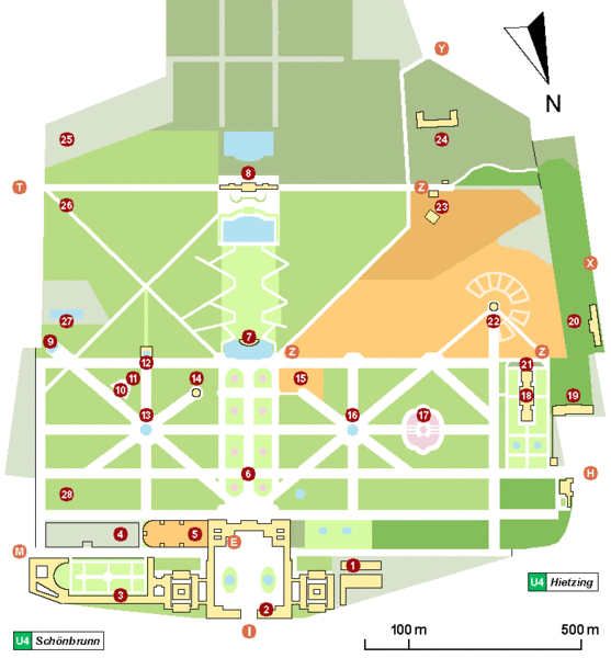
Schönbrunn (Vienna) palace and gardens map As of now, the characters and numbers mean the following:
(1) - 'Wagenburg', ehemalige Winterreitschule, jetzt Museum für Kutschen - 'Wagenburg', a carriage museum. (9) - Obeliskbrunnen - Obelisk Fountain. (22) - Zoo und 'Kaiserpavillion' - world's eldest existing zoo, with 'Emperor's pavilion' (now a Café). (23) - 'Tirolerhaus' und 'Tiroler Garten', now part of the zoo. 'Tirolerhaus' restaurant is outside the zoo. Side entrance to zoo (open temporarily). (24) - Bundesforschungs- und Ausbildungszentrum für Wald, Naturgefahren und Landschaft (BFW) - Federal Research and Training Centre for Forests, Natural Hazards and Landscape - formerly Forstliche Bundes-Versuchsanstalt (FBVA) (25) - Höhere Bundeslehr- und Versuchsanstalt für Gartenbau (26) - 'Kleine Gloriette' - 'Little Gloriette' (27) - 'Schönbrunner Bad' (a public swimming pool). (28) - 'Meierei', now a restaurant. |
| วันที่ | |
| แหล่งที่มา | งานของตัว |
| ผู้สร้างสรรค์ | Wolfgang H. Wögerer, Wien |
| การอนุญาต (การใช้ไฟล์นี้ใหม่) |
ข้าพเจ้า ในฐานะผู้ถือลิขสิทธิ์ของภาพหรือสื่อนี้ อนุญาตให้ใช้ภาพหรือสื่อนี้ภายใต้เงื่อนไขต่อไปนี้ ไฟล์นี้อยู่ภายใต้สัญญาอนุญาต ครีเอทีฟคอมมอนส์ แบบแสดงที่มา-อนุญาตแบบเดียวกัน 3.0 ต้นฉบับ
|
| Annotations | This image is annotated: View the annotations at Commons |


ประวัติไฟล์
คลิกวันที่/เวลาเพื่อดูไฟล์ที่ปรากฏในขณะนั้น
| วันที่/เวลา | รูปย่อ | ขนาด | ผู้ใช้ | ความเห็น | |
|---|---|---|---|---|---|
| ปัจจุบัน | 21:05, 20 มีนาคม 2551 | | 780 × 840 (27 กิโลไบต์) | W. | |
| 02:00, 28 กุมภาพันธ์ 2551 |  | 780 × 840 (25 กิโลไบต์) | W. | ||
| 21:59, 26 กุมภาพันธ์ 2551 |  | 780 × 820 (25 กิโลไบต์) | W. | ||
| 00:17, 20 กุมภาพันธ์ 2551 |  | 800 × 850 (23 กิโลไบต์) | W. | {{Information= Schönbrunn (Vienna) palace and gardens rough map. This map tries to show buildings of major public interest, monuments, garden partions, alleys and the main entrances used by visitors. It was created by trying to merge officially available |
หน้าที่มีภาพนี้
หน้าต่อไปนี้ โยงมาที่ภาพนี้:
การใช้ไฟล์ข้ามโครงการ
วิกิอื่นต่อไปนี้ใช้ไฟล์นี้:
- การใช้บน de.wikipedia.org
- การใช้บน de.wikiversity.org
- การใช้บน de.wikivoyage.org
- การใช้บน en.wikipedia.org
- การใช้บน fa.wikipedia.org
- การใช้บน fr.wikipedia.org
- การใช้บน hr.wikipedia.org
- การใช้บน hu.wikipedia.org
- การใช้บน it.wikipedia.org
- การใช้บน ja.wikipedia.org
- การใช้บน mk.wikipedia.org
- การใช้บน mt.wikipedia.org
- การใช้บน pa.wikipedia.org
- การใช้บน ru.wikipedia.org
- การใช้บน sh.wikipedia.org
- การใช้บน sv.wikipedia.org
- การใช้บน vi.wikipedia.org