
ไฟล์:PIA21260 - Earth and Its Moon, as Seen From Mars.jpg
ไม่มีภาพที่มีรายละเอียดสูงกว่านี้
PIA21260_-_Earth_and_Its_Moon,_as_Seen_From_Mars.jpg (657 × 358 พิกเซล, ขนาดไฟล์: 7 กิโลไบต์, ชนิดไมม์: image/jpeg)
| รูปภาพหรือไฟล์เสียงนี้ ต้นฉบับอยู่ที่ คอมมอนส์ รายละเอียดด้านล่าง เป็นข้อความที่แสดงผลจาก ไฟล์ต้นฉบับในคอมมอนส์
|
ความย่อ
| คำอธิบาย |
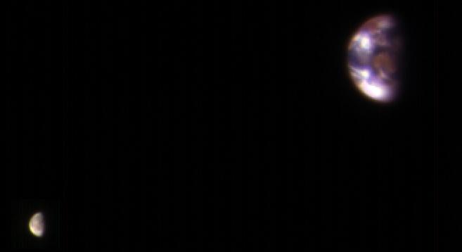
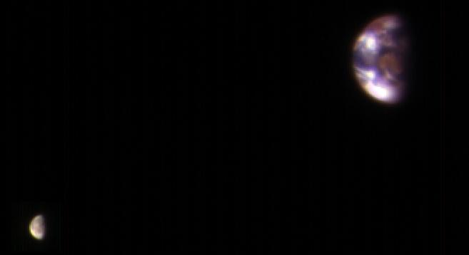
English: This composite image of Earth and its moon, as seen from Mars, combines the best Earth image with the best moon image from four sets of images acquired on Nov. 20, 2016, by the High Resolution Imaging Science Experiment (HiRISE) camera on NASA's Mars Reconnaissance Orbiter. Each was separately processed prior to combining them so that the moon is bright enough to see. The moon is much darker than Earth and would barely be visible at the same brightness scale as Earth. The combined view retains the correct sizes and positions of the two bodies relative to each other. HiRISE takes images in three wavelength bands: infrared, red, and blue-green. These are displayed here as red, green, and blue, respectively. This is similar to Landsat images in which vegetation appears red. The reddish feature in the middle of the Earth image is Australia. Southeast Asia appears as the reddish area (due to vegetation) near the top; Antarctica is the bright blob at bottom-left. Other bright areas are clouds. These images were acquired for calibration of HiRISE data, since the spectral reflectance of the Moon's near side is very well known. When the component images were taken, Mars was about 127 million miles (205 million kilometers) from Earth. A previous HiRISE image of Earth and the moon is online at PIA10244. The University of Arizona, Tucson, operates HiRISE, which was built by Ball Aerospace & Technologies Corp., Boulder, Colo. NASA's Jet Propulsion Laboratory, a division of Caltech in Pasadena, California, manages the Mars Reconnaissance Orbiter Project for NASA's Science Mission Directorate, Washington. |
| วันที่ | (published 2017-01-06) |
| แหล่งที่มา | Catalog page · Full-res (JPEG · TIFF) |
| ผู้สร้างสรรค์ | NASA/JPL-Caltech/Univ. of Arizona |
This image or video was catalogued by Jet Propulsion Laboratory of the United States National Aeronautics and Space Administration (NASA) under Photo ID: PIA21260. This tag does not indicate the copyright status of the attached work. A normal copyright tag is still required. See Commons:Licensing. Other languages:
|
 |
This media is a product of the Mars Reconnaissance Orbiter mission Credit and attribution belongs to the mission team, if not already specified in the "author" row |
Simulated comparison:

การอนุญาตใช้สิทธิ
| ภาพนี้เป็นสาธารณสมบัติ เนื่องจากเป็นภาพที่สร้างขึ้นโดยองค์การบริหารการบินและอวกาศแห่งชาติ (NASA) ซึ่งตามนโยบายด้านลิขสิทธิ์ของนาซาระบุไว้ว่า "ภาพและสื่อต่าง ๆ ของนาซาไม่ได้รับการคุ้มครองโดยลิขสิทธิ์ยกเว้นจะระบุไว้ว่ามีลิขสิทธิ์" ดูเพิ่มที่ หน้านโยบายด้านลิขสิทธิ์ของนาซา หรือ นโยบายการใช้ภาพของ JPL | ||
 |
คำเตือน:
|
ประวัติไฟล์
คลิกวันที่/เวลาเพื่อดูไฟล์ที่ปรากฏในขณะนั้น
| วันที่/เวลา | รูปย่อ | ขนาด | ผู้ใช้ | ความเห็น | |
|---|---|---|---|---|---|
| ปัจจุบัน | 03:29, 7 มกราคม 2560 | | 657 × 358 (7 กิโลไบต์) | PhilipTerryGraham | User created page with UploadWizard |
หน้าที่มีภาพนี้
หน้าต่อไปนี้ โยงมาที่ภาพนี้:
การใช้ไฟล์ข้ามโครงการ
วิกิอื่นต่อไปนี้ใช้ไฟล์นี้:
- การใช้บน ar.wikipedia.org
- การใช้บน ca.wikipedia.org
- การใช้บน de.wikiversity.org
- การใช้บน en.wikipedia.org
- การใช้บน es.wikipedia.org
- การใช้บน eu.wikipedia.org
- การใช้บน fa.wikipedia.org
- การใช้บน he.wikipedia.org
- การใช้บน hr.wikipedia.org
- การใช้บน ja.wikipedia.org
- การใช้บน mnw.wikipedia.org
- การใช้บน ro.wikipedia.org
- การใช้บน ru.wikipedia.org
- การใช้บน simple.wikipedia.org