
ไฟล์:ORD airport map.PNG

ขนาดของตัวอย่างนี้: 391 × 600 พิกเซล ความละเอียดอื่น: 156 × 240 พิกเซล | 313 × 480 พิกเซล | 807 × 1,238 พิกเซล
ดูภาพที่มีความละเอียดสูงกว่า (807 × 1,238 พิกเซล, ขนาดไฟล์: 247 กิโลไบต์, ชนิดไมม์: image/png)
| รูปภาพหรือไฟล์เสียงนี้ ต้นฉบับอยู่ที่ คอมมอนส์ รายละเอียดด้านล่าง เป็นข้อความที่แสดงผลจาก ไฟล์ต้นฉบับในคอมมอนส์
|

|
ภาพนี้มีภาพในรูปแบบเวกเตอร์ (SVG)
หากภาพ SVG ทำให้การแสดงผลดีกว่า หน้าที่ใช้ภาพนี้ควรเปลี่ยนไปใช้ภาพ SVG แทน File:ORD airport map.PNG → File:ORD Airport Diagram.svg
สำหรับข้อมูลเพิ่มเติมเกี่ยวกับภาพเวกเตอร์ ดูที่ การเปลี่ยนไปใช้ภาพ SVG ในคอมมอนส์ นอกจากนี้สามารถดูเพิ่มเติมเกี่ยวกับ ข้อมูลเกี่ยวกับการรองรับภาพ SVG สำหรับซอฟต์แวร์มีเดียวิกิ ได้ |
 |

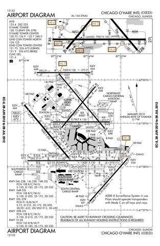
Airport diagram of O'Hare International Airport
This image or file is a work of a Federal Aviation Administration employee, taken or made as part of that person's official duties. As a work of the U.S. federal government, the image is in the public domain in the United States.
|
 |
ประวัติไฟล์
คลิกวันที่/เวลาเพื่อดูไฟล์ที่ปรากฏในขณะนั้น
| วันที่/เวลา | รูปย่อ | ขนาด | ผู้ใช้ | ความเห็น | |
|---|---|---|---|---|---|
| ปัจจุบัน | 05:50, 13 กรกฎาคม 2555 | | 807 × 1,238 (247 กิโลไบต์) | Phongn | Update to 28 Jun 2012 version. |
| 08:59, 24 ตุลาคม 2553 |  | 807 × 1,238 (306 กิโลไบต์) | Mareklug | Reverted to version as of 01:52, 24 October 2010 | |
| 08:58, 24 ตุลาคม 2553 |  | 807 × 1,238 (306 กิโลไบต์) | Mareklug | newer, 2nd attempt. | |
| 08:52, 24 ตุลาคม 2553 |  | 807 × 1,238 (306 กิโลไบต์) | Mareklug | newer, larger version (Oct 21, 2010) | |
| 23:40, 7 พฤษภาคม 2553 |  | 387 × 594 (98 กิโลไบต์) | Spartan S58 | Showing the shortening of 32L'14R, and changed taxi from P to U. | |
| 06:59, 19 กุมภาพันธ์ 2552 |  | 774 × 1,188 (129 กิโลไบต์) | Mahahahaneapneap | Compressed | |
| 10:54, 11 ธันวาคม 2551 |  | 774 × 1,188 (257 กิโลไบต์) | Jalentz | Updated to include opening of runway 9L/27R November 2008 | |
| 02:33, 23 กรกฎาคม 2550 |  | 1,570 × 2,285 (305 กิโลไบต์) | Mareklug | Updated (version from 5 July 2007 showing redesignated runway 10/28 which used to be 9R/27L) airport diagram of O'Hare International Airport {{PD-USGov-FAA}} | |
| 04:15, 7 มกราคม 2549 |  | 733 × 1,133 (134 กิโลไบต์) | Cmprince | Aiport diagram of O'Hare International Airport {{PD-USGov-FAA}} |
หน้าที่มีภาพนี้
ไม่มีหน้าใดโยงมาที่ภาพนี้