
ไฟล์:Nepenthes villosa distribution.png
ขนาดของตัวอย่างนี้: 544 × 599 พิกเซล ความละเอียดอื่น: 218 × 240 พิกเซล | 436 × 480 พิกเซล | 832 × 916 พิกเซล
ดูภาพที่มีความละเอียดสูงกว่า (832 × 916 พิกเซล, ขนาดไฟล์: 789 กิโลไบต์, ชนิดไมม์: image/png)
| รูปภาพหรือไฟล์เสียงนี้ ต้นฉบับอยู่ที่ คอมมอนส์ รายละเอียดด้านล่าง เป็นข้อความที่แสดงผลจาก ไฟล์ต้นฉบับในคอมมอนส์
|
ความย่อ
| คำอธิบาย |
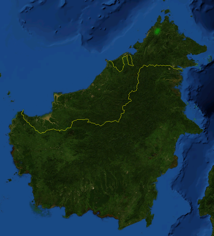
Distribution of Nepenthes villosa. Distribution:
|
| วันที่ | 11 พฤษภาคม พ.ศ. 2549 (original upload date) |
| แหล่งที่มา | นำเข้าจาก en.wikipedia มายังคอมมอนส์ |
| ผู้สร้างสรรค์ | Mgiganteus1 ที่ วิกิพีเดียภาษาอังกฤษ |
การอนุญาตใช้สิทธิ
| This image is in the public domain because it is a screenshot from NASA’s globe software World Wind using a public domain layer, such as Blue Marble, MODIS, Landsat, SRTM, USGS or GLOBE.
|
 |
| งานนี้ได้ถูกเผยแพร่สู่สาธารณสมบัติโดยเจ้าของ Mgiganteus1 ที่ วิกิพีเดียภาษาอังกฤษ ซึ่งมีผลทั่วโลก ในบางประเทศ การกระทำดังกล่าวอาจไม่สามารถทำได้ตามกฎหมาย Mgiganteus1 อนุญาตให้ทุกคนมีสิทธิ์ในการใช้ไฟล์นี้ในทุกเหตุผลการใช้ โดยไม่มีมีเงื่อนไข เว้นแต่กฎหมายไม่อนุญาตให้ทำเช่นนั้น |
บันทึกการอัพโหลด
The original description page was here. All following user names refer to en.wikipedia.
- 2006-05-11 00:09 Mgiganteus1 832×916×8 (808192 bytes) Distribution of ''Nepenthes villosa'' '''Distribution:''' * Mount Kinabalu * Mount Tambuyukon Based on map from NASA's open source World Wind program. {{PD-USGov-NASA}} {{PD-self}}
ประวัติไฟล์
คลิกวันที่/เวลาเพื่อดูไฟล์ที่ปรากฏในขณะนั้น
| วันที่/เวลา | รูปย่อ | ขนาด | ผู้ใช้ | ความเห็น | |
|---|---|---|---|---|---|
| ปัจจุบัน | 03:10, 9 กรกฎาคม 2550 | | 832 × 916 (789 กิโลไบต์) | ToNToNi | {{Information |Description=Distribution of ''Nepenthes villosa''. '''Distribution:''' * Mount Kinabalu * Mount Tambuyukon Based on map from NASA's open source World Wind program. |Source=Originally from [http://en.wikipedia.org en.wikipedia]; descripti |
หน้าที่มีภาพนี้
ไม่มีหน้าใดโยงมาที่ภาพนี้
การใช้ไฟล์ข้ามโครงการ
วิกิอื่นต่อไปนี้ใช้ไฟล์นี้:
- การใช้บน arz.wikipedia.org
- การใช้บน ca.wikipedia.org
- การใช้บน ceb.wikipedia.org
- การใช้บน en.wikipedia.org
- การใช้บน sv.wikipedia.org
- การใช้บน www.wikidata.org
- การใช้บน zh.wikipedia.org