
ไฟล์:Mwamongu water source.jpg

ดูภาพที่มีความละเอียดสูงกว่า (946 × 768 พิกเซล, ขนาดไฟล์: 344 กิโลไบต์, ชนิดไมม์: image/jpeg)
| รูปภาพหรือไฟล์เสียงนี้ ต้นฉบับอยู่ที่ คอมมอนส์ รายละเอียดด้านล่าง เป็นข้อความที่แสดงผลจาก ไฟล์ต้นฉบับในคอมมอนส์
|
| คำอธิบาย |
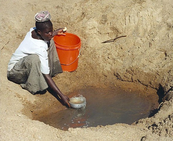
English: Mwamanongu Village water source, Tanzania. "In Meatu district, Shinyanga region, Tanzania, water most often comes from open holes dug in the sand of dry riverbeds, and it is invariably contaminated." .
Français : Point d'eau du village de Mwamanongu, en Tanzanie. "Dans le district de Meatu (région de Shinyanga, Tanzanie), L'eau provient le plus souvent de trous creusés dans le sable de lits de rivières asséchées. Elle est systématiquement contaminée." |
||
| วันที่ | |||
| แหล่งที่มา |
http://solarcooking.wikia.com/wiki/Image:Mwamongu_water_source.jpg, |
||
| ผู้สร้างสรรค์ | Bob Metcalf | ||
| การอนุญาต (การใช้ไฟล์นี้ใหม่) |
|
| ตำแหน่งที่ตั้งกล้อง | | ภาพนี้และภาพอื่น ๆ ณ สถานที่เดียวกันที่ OpenStreetMap |
|---|
Location note from author: If one goes north from the city of Tabora, follow it to Shinyanga. Shinyanga town is the administrative location of the Shinyanga Region, which includes several districts, Meatu District being one of them. From Shinyanga, go east to find the town of Mhunze, which I think is what I know as Mwanhuze, the District headquarters. It was from Mhunze that we took a Land Rover a bit northwest, I think, perhaps 15 km, to reach Mwamanongu. The driver knew how to get to these villages, but there were no road signs anywhere, nor any landmarks on the flat land, and the 'road' was just a path, often in lousy condition for the rare vehicle that would use it.
Editor's note: Mwanhuze and Mwamanongu are wards in en:Meatu District.[1] Meatu is a trapezoidal region that borders the western end of Lake Eyasi and extends roughly 70 km to the northwest.[2] Mhunze is a ward in en:Bariadi District. Walter Siegmund (talk) 05:02, 14 January 2008 (UTC)

|
ภาพนี้ได้รับการประเมินภายใต้ เกณฑ์ภาพอันทรงคุณค่า และถือว่าเป็น ภาพอันทรงคุณค่าที่สุดในคอมมอนส์ ภายใต้ขอบเขต: Primitive water supply. คุณสามารถดูการเสนอชื่อได้ ที่นี่. |
ประวัติไฟล์
คลิกวันที่/เวลาเพื่อดูไฟล์ที่ปรากฏในขณะนั้น
| วันที่/เวลา | รูปย่อ | ขนาด | ผู้ใช้ | ความเห็น | |
|---|---|---|---|---|---|
| ปัจจุบัน | 06:39, 13 มกราคม 2551 | | 946 × 768 (344 กิโลไบต์) | Wsiegmund | PE; cropped white borders |
| 06:38, 13 มกราคม 2551 |  | 1,024 × 768 (149 กิโลไบต์) | Wsiegmund | Upload slightly larger version | |
| 21:58, 12 มกราคม 2551 |  | 944 × 704 (85 กิโลไบต์) | Wsiegmund | {{Information |Description=Mwamongu Village water source, Tanzania |Source=Wikia:c:solarcooking:Image:Mwamongu_water_source.jpg |Date=2006-06-06 |Author=Bob Metcalf |Permission={{PD-author|Bob Metcalf}} |other_versions= }} |
หน้าที่มีภาพนี้
หน้าต่อไปนี้ โยงมาที่ภาพนี้:
การใช้ไฟล์ข้ามโครงการ
วิกิอื่นต่อไปนี้ใช้ไฟล์นี้:
- การใช้บน af.wikipedia.org
- การใช้บน ar.wikipedia.org
- การใช้บน ca.wikipedia.org
- การใช้บน da.wikipedia.org
- การใช้บน de.wikipedia.org
- การใช้บน de.wikibooks.org
- การใช้บน de.wiktionary.org
- การใช้บน el.wikipedia.org
- การใช้บน en.wikipedia.org
- การใช้บน en.wikibooks.org
- การใช้บน en.wikiversity.org
- การใช้บน en.wiktionary.org
- การใช้บน es.wikipedia.org
- การใช้บน eu.wikipedia.org
- การใช้บน fi.wikipedia.org
- การใช้บน fr.wikipedia.org
- การใช้บน fr.wiktionary.org
- การใช้บน ga.wikipedia.org
- การใช้บน gur.wikipedia.org
- การใช้บน he.wikipedia.org
- การใช้บน hi.wikipedia.org
- การใช้บน hu.wikibooks.org
- การใช้บน id.wikipedia.org
- การใช้บน ig.wikipedia.org
- การใช้บน io.wiktionary.org
- การใช้บน it.wikipedia.org
ดูการใช้ข้ามโครงการเพิ่มเติมของไฟล์นี้