
ไฟล์:Low pressure system over Iceland.jpg

ขนาดของตัวอย่างนี้: 692 × 600 พิกเซล ความละเอียดอื่น: 277 × 240 พิกเซล | 554 × 480 พิกเซล | 886 × 768 พิกเซล | 1,182 × 1,024 พิกเซล | 2,363 × 2,048 พิกเซล | 6,000 × 5,200 พิกเซล
ดูภาพที่มีความละเอียดสูงกว่า (6,000 × 5,200 พิกเซล, ขนาดไฟล์: 3.86 เมกะไบต์, ชนิดไมม์: image/jpeg)
| รูปภาพหรือไฟล์เสียงนี้ ต้นฉบับอยู่ที่ คอมมอนส์ รายละเอียดด้านล่าง เป็นข้อความที่แสดงผลจาก ไฟล์ต้นฉบับในคอมมอนส์
|
ความย่อ
| คำอธิบาย |
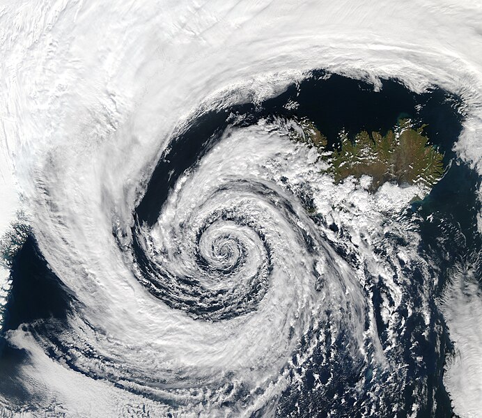
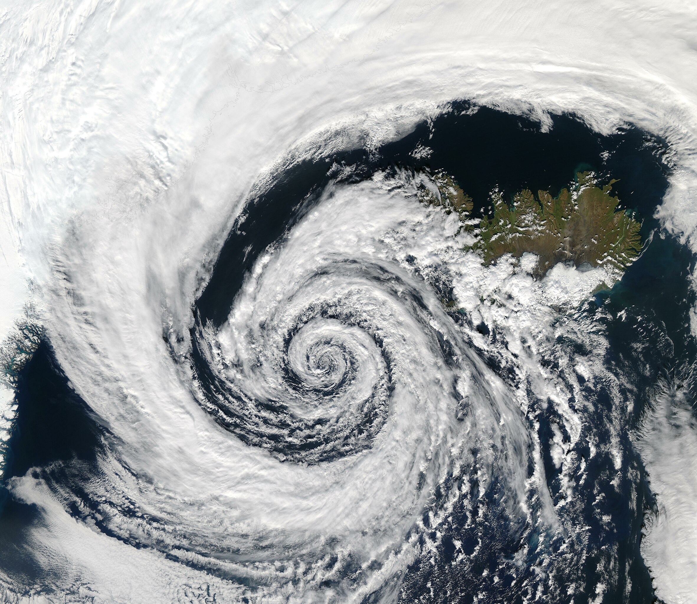
English: A beautifully-formed low-pressure system swirls off the southwestern coast of Iceland, illustrating the maxim that "nature abhors a vacuum." The vacuum in this case would be a region of low atmospheric pressure. In order to fill this void, air from a nearby high-pressure system moves in, in this case bringing clouds along for the ride. And because this low-pressure system occurred in the Northern Hemisphere, the winds spun in toward the center of the low-pressure system in a counter-clockwise direction; a phenomenon known as the Coriolis force (in the Southern Hemisphere, the Coriolis force would be manifested in a clockwise direction of movement).
The clouds in the image resembled pulled cotton and lace as they spun in a lazy hurricane-like pattern. This huge system swirled over the Denmark Strait in between Greenland and Iceland. The image was taken by the Aqua MODIS instrument on September 4, 2003.
Español: Imagen satelital que muestra una depresión centrada en el estrecho de Dinamarca entre Islandia y Groenlandia. Los vientos, atraídos por la zona de baja presión en el centro, doble bajan el efecto de la fuerza de Coriolis, que dan la apariencia de caracol desde el espacio.
Français : Image satellite montrant une dépression centrée sur le détroit du Danemark, entre l'Islande et le Groenland. Les vents, attirés par la zone de basses pressions au centre, se courbent sous l'effet de la force de coriolis, ce qui donne l'aspect spiralé observé ici. |
| วันที่ | Taken on 4 กันยายน พ.ศ. 2546, 14:10 |
| แหล่งที่มา | https://visibleearth.nasa.gov/images/68992/low-off-iceland |
| ผู้สร้างสรรค์ | NASA/GSFC, MODIS Rapid Response Team, Jacques Descloitres |
Assessment
|

Deutsch: Dieses Bild wurde als Bild der Woche auf der tschechischen Wikipedia für die 30 Woche ausgewählt, 2019. English: This image was selected as a picture of the week on the Czech Wikipedia for 30th week, 2019. Français : Cette image est sélectionnée en tant qu’image de la semaine sur la Wikipédia Tchèque pour la 30e semaine de 2019. Italiano: Questa immagine è stata selezionata come Immagine della settimana su Wikipedia in ceco per la XXX settimana del 2019. Македонски: Сликава е избрана за слика на неделата на чешката Википедија за XXX недела од 2019 година. Русский: Эта иллюстрация была выбрана изображением недели в чешском разделе «Википедии» для недели номер 30 2019 года. Українська: Ця ілюстрація була вибрана зображенням тижня в чеському розділі «Вікіпедії» для тижня номер 30, 2019 року. |
การอนุญาตใช้สิทธิ
| ภาพนี้เป็นสาธารณสมบัติ เนื่องจากเป็นภาพที่สร้างขึ้นโดยองค์การบริหารการบินและอวกาศแห่งชาติ (NASA) ซึ่งตามนโยบายด้านลิขสิทธิ์ของนาซาระบุไว้ว่า "ภาพและสื่อต่าง ๆ ของนาซาไม่ได้รับการคุ้มครองโดยลิขสิทธิ์ยกเว้นจะระบุไว้ว่ามีลิขสิทธิ์" ดูเพิ่มที่ หน้านโยบายด้านลิขสิทธิ์ของนาซา หรือ นโยบายการใช้ภาพของ JPL | ||
 |
คำเตือน:
|

|
ภาพนี้ได้รับการประเมินภายใต้ เกณฑ์ภาพอันทรงคุณค่า และถือว่าเป็น ภาพอันทรงคุณค่าที่สุดในคอมมอนส์ ภายใต้ขอบเขต: Icelandic Low. คุณสามารถดูการเสนอชื่อได้ ที่นี่. |
ประวัติไฟล์
คลิกวันที่/เวลาเพื่อดูไฟล์ที่ปรากฏในขณะนั้น
| วันที่/เวลา | รูปย่อ | ขนาด | ผู้ใช้ | ความเห็น | |
|---|---|---|---|---|---|
| ปัจจุบัน | 20:23, 16 ธันวาคม 2552 | | 6,000 × 5,200 (3.86 เมกะไบต์) | Tryphon | Higher resolution, from http://visibleearth.nasa.gov/view_detail.php?id=6204. |
| 02:14, 5 พฤศจิกายน 2548 |  | 3,500 × 3,033 (2.31 เมกะไบต์) | Brian0918 | A beautifully-formed low-pressure system swirls off the southeastern coast of Iceland, illustrating the maxim that "nature abhors a vacuum." The vacuum in this case would be a region of low atmospheric pressure. In order to fill this void, air from a near |
หน้าที่มีภาพนี้
หน้าต่อไปนี้ โยงมาที่ภาพนี้:
การใช้ไฟล์ข้ามโครงการ
วิกิอื่นต่อไปนี้ใช้ไฟล์นี้:
- การใช้บน af.wikipedia.org
- การใช้บน anp.wikipedia.org
- การใช้บน ar.wikipedia.org
- การใช้บน ast.wikipedia.org
- การใช้บน beta.wikiversity.org
- การใช้บน bg.wikipedia.org
- การใช้บน bh.wikipedia.org
- การใช้บน bn.wikipedia.org
- การใช้บน br.wikipedia.org
- การใช้บน ca.wikipedia.org
- การใช้บน cs.wikipedia.org
- การใช้บน cv.wikipedia.org
- การใช้บน cy.wikipedia.org
- การใช้บน da.wikipedia.org
- การใช้บน da.wikibooks.org
- การใช้บน de.wikipedia.org
- Wetter
- Tiefdruckgebiet
- Logarithmische Spirale
- Corioliskraft
- Wikipedia:Exzellente Bilder
- Islandtief
- Portal:Wetter und Klima
- Portal:Wetter und Klima/MetVerzeichnis
- Wikipedia:Kandidaten für exzellente Bilder/Archiv2007/5
- Datei:Low pressure system over Iceland.jpg
- Wikipedia:Exzellente Bilder/Naturwissenschaften
ดูการใช้ข้ามโครงการเพิ่มเติมของไฟล์นี้