
ไฟล์:LocationKingdomAraucania.svg

ขนาดของตัวอย่าง PNG นี้ของไฟล์ SVG นี้: 800 × 400 พิกเซล ความละเอียดอื่น: 320 × 160 พิกเซล | 640 × 320 พิกเซล | 1,024 × 512 พิกเซล | 1,280 × 640 พิกเซล | 2,560 × 1,280 พิกเซล | 1,000 × 500 พิกเซล
ดูภาพที่มีความละเอียดสูงกว่า ((ไฟล์ SVG, 1,000 × 500 พิกเซล, ขนาดไฟล์: 987 กิโลไบต์))
| รูปภาพหรือไฟล์เสียงนี้ ต้นฉบับอยู่ที่ คอมมอนส์ รายละเอียดด้านล่าง เป็นข้อความที่แสดงผลจาก ไฟล์ต้นฉบับในคอมมอนส์
|
ความย่อ
| คำอธิบาย |
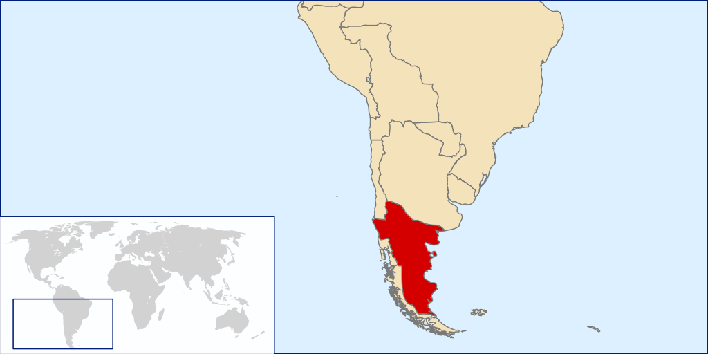
Español: Mapa localizador del Reino de la Araucanía y la Patagonia (1860-1862 aprox.).
Este mapa solo representa una idea básica de la localización del territorio reclamado por este estado no reconocido, puesto que no existe certeza exacta de las zonas reclamadas por el supuesto reino. Los mapas de otros países tampoco son representaciones fidedignas de sus fronteras en la época. La zona patagónica de Aisén, Magallanes y Tierra del Fuego aparece como un territorio distinto a Chile y Argentina al ser una zona reclamada por ambos países durante la época. La zona de la Patagonia Oriental, también reclamada por ambos, era cubierta por las reclamaciones del Reino de la Araucanía y la PatagoniaEnglish: Locator map of the Kingdom of Araucania and Patagonia (approx. 1860-1862).
The map shows only an idea of the territory disputed by the unrecognized Kingdom because there isn't any exact definition of it. Also the historical frontiers of other countries aren't accurate. The zone of Aysen, Magallanes and Tierra del Fuego islands are shown as a separate entity because it was disputed by Chile and Argentina at the time. Most of Western Patagonia (also disputed by both countries) are shown as a territory of the Kingdom. |
| วันที่ | |
| แหล่งที่มา | self-made based in Image:LocationChile.svg and Image:Continents.svg |
| ผู้สร้างสรรค์ | B1mbo |
การอนุญาตใช้สิทธิ
ข้าพเจ้า ในฐานะผู้ถือลิขสิทธิ์ของภาพหรือสื่อนี้ อนุญาตให้ใช้ภาพหรือสื่อนี้ภายใต้เงื่อนไขต่อไปนี้

|
อนุญาตให้คัดลอก แจกจ่ายและ/หรือดัดแปรเอกสารนี้ภายใต้เงื่อนไขของสัญญาอนุญาตเอกสารเสรีของกนู รุ่น 1.2 หรือรุ่นใด ๆ นับจากนี้ที่ออกโดยมูลนิธิซอฟต์แวร์เสรี โดยไม่มีส่วนใดห้ามแก้ไข ไม่มีข้อความปกหน้าและปกหลัง สำเนาของสัญญาอนุญาตรวมอยู่ในส่วนชื่อ สัญญาอนุญาตเอกสารเสรีของกนู |
This file is licensed under the Creative Commons Attribution-Share Alike 4.0 International, 3.0 Unported, 2.5 Generic, 2.0 Generic and 1.0 Generic license.
- คุณสามารถ:
- ที่จะแบ่งปัน – ที่จะทำสำเนา แจกจ่าย และส่งงานดังกล่าวต่อไป
- ที่จะเรียบเรียงใหม่ – ที่จะดัดแปลงงานดังกล่าว
- ภายใต้เงื่อนไขต่อไปนี้:
- แสดงที่มา – คุณต้องให้เกียรติเจ้าของงานอย่างเหมาะสม โดยเพิ่มลิงก์ไปยังสัญญาอนุญาต และระบุหากมีการเปลี่ยนแปลง คุณอาจทำเช่นนี้ได้ในรูปแบบใดก็ได้ตามควร แต่ต้องไม่ใช่ในลักษณะที่แนะว่าผู้ให้อนุญาตสนับสนุนคุณหรือการใช้งานของคุณ
- อนุญาตแบบเดียวกัน – หากคุณดัดแปลง เปลี่ยนรูป หรือต่อเติมงานนี้ คุณต้องใช้สัญญาอนุญาตแบบเดียวกันหรือแบบที่เหมือนกับสัญญาอนุญาตที่ใช้กับงานนี้เท่านั้น
คุณสามารถเลือกสัญญาอนุญาตดังกล่าวตามต้องการ
ประวัติไฟล์
คลิกวันที่/เวลาเพื่อดูไฟล์ที่ปรากฏในขณะนั้น
| วันที่/เวลา | รูปย่อ | ขนาด | ผู้ใช้ | ความเห็น | |
|---|---|---|---|---|---|
| ปัจจุบัน | 09:50, 29 มีนาคม 2551 | | 1,000 × 500 (987 กิโลไบต์) | B1mbo | {{Information |Description={{es|Mapa localizador del Reino de la Araucanía y la Patagonia (1860-1862 aprox.). Este mapa solo representa una idea básica de la localización del territorio reclamado por este |
หน้าที่มีภาพนี้
หน้าต่อไปนี้ โยงมาที่ภาพนี้:
การใช้ไฟล์ข้ามโครงการ
วิกิอื่นต่อไปนี้ใช้ไฟล์นี้:
- การใช้บน ar.wikipedia.org
- การใช้บน br.wikipedia.org
- การใช้บน ca.wikipedia.org
- การใช้บน en.wikipedia.org
- การใช้บน es.wikipedia.org
- การใช้บน fi.wikipedia.org
- การใช้บน fr.wikipedia.org
- การใช้บน ga.wikipedia.org
- การใช้บน gl.wikipedia.org
- การใช้บน he.wikipedia.org
- การใช้บน id.wikipedia.org
- การใช้บน it.wikipedia.org
- การใช้บน ja.wikipedia.org
- การใช้บน ko.wikipedia.org
- การใช้บน nl.wikipedia.org
- การใช้บน pt.wikipedia.org
- การใช้บน sv.wikipedia.org
- การใช้บน www.wikidata.org
- การใช้บน zh.wikipedia.org