
ไฟล์:Landing zone 'N' 7 June 1944.jpg
ขนาดของตัวอย่างนี้: 646 × 599 พิกเซล ความละเอียดอื่น: 259 × 240 พิกเซล | 518 × 480 พิกเซล
ดูภาพที่มีความละเอียดสูงกว่า (800 × 742 พิกเซล, ขนาดไฟล์: 86 กิโลไบต์, ชนิดไมม์: image/jpeg)
| รูปภาพหรือไฟล์เสียงนี้ ต้นฉบับอยู่ที่ คอมมอนส์ รายละเอียดด้านล่าง เป็นข้อความที่แสดงผลจาก ไฟล์ต้นฉบับในคอมมอนส์
|
| คำอธิบาย |
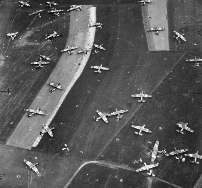
English: Oblique photographic-reconnaissance vertical, taken from 800 feet, showing part of Landing Zone 'N', north of Ranville, Normandy, on the day following Operation MALLARD : the airborne landing of 6th Airlanding Brigade and the Airborne Armoured Reconnaissance Regiment in the evening of 6 June 1944. Airspeed Horsa troop-carrying gliders and one damaged GAL Hamilcar tank-carrying glider (lower right) litter this part of the LZ close to the Ranville-Salanelles road. |
|||
| วันที่ | ||||
| แหล่งที่มา |
|
|||
| ผู้สร้างสรรค์ | Kelly (Flt Lt): No. 106 (PR) Group. | |||
| การอนุญาต (การใช้ไฟล์นี้ใหม่) |
|


บันทึกการอัพโหลด
นำเข้าจาก en.wikipedia มายังคอมมอนส์ โดย Rcbutcher โดยใช้ CommonsHelper
The original description page was here. All following user names refer to en.wikipedia.
- 2011-05-17 11:43 Jncraton 300×256× (16465 bytes) Lossless crop to remove watermark
- 2011-05-03 19:40 Jim Sweeney 300×277× (18111 bytes) {{Information | description = Oblique photographic-reconnaissance vertical, taken from 800 feet, showing part of Landing Zone 'N', north of Ranville, Normandy, on the day following Operation MALLARD: the airborne landing of [[6th Airlanding Brigade]] and
ประวัติไฟล์
คลิกวันที่/เวลาเพื่อดูไฟล์ที่ปรากฏในขณะนั้น
| วันที่/เวลา | รูปย่อ | ขนาด | ผู้ใช้ | ความเห็น | |
|---|---|---|---|---|---|
| ปัจจุบัน | 14:53, 23 กรกฎาคม 2555 | | 800 × 742 (86 กิโลไบต์) | Rcbutcher | replaced with new higher-quality version from IWM |
| 14:45, 23 กรกฎาคม 2555 |  | 300 × 256 (16 กิโลไบต์) | File Upload Bot (Magnus Manske) | Transfered from en.wikipedia by User:rcbutcher using CommonsHelper |
หน้าที่มีภาพนี้
หน้าต่อไปนี้ โยงมาที่ภาพนี้:
การใช้ไฟล์ข้ามโครงการ
วิกิอื่นต่อไปนี้ใช้ไฟล์นี้:
- การใช้บน en.wikipedia.org
- การใช้บน fa.wikipedia.org
- การใช้บน fr.wikipedia.org
- การใช้บน pl.wikipedia.org
- การใช้บน www.wikidata.org