
ไฟล์:Lake St Clair by Sentinel-2.jpg

ดูภาพที่มีความละเอียดสูงกว่า (3,600 × 3,600 พิกเซล, ขนาดไฟล์: 11.02 เมกะไบต์, ชนิดไมม์: image/jpeg)
| รูปภาพหรือไฟล์เสียงนี้ ต้นฉบับอยู่ที่ คอมมอนส์ รายละเอียดด้านล่าง เป็นข้อความที่แสดงผลจาก ไฟล์ต้นฉบับในคอมมอนส์
|
ความย่อ
| คำอธิบาย |
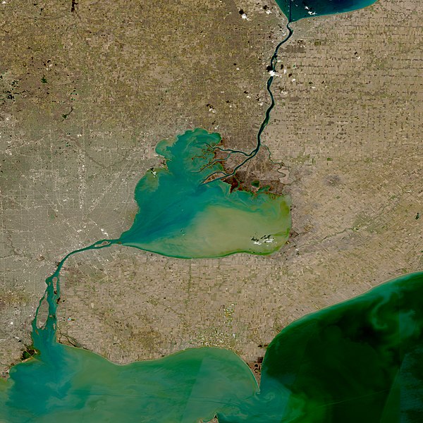
English: Lake St. Clair (Center), St Clair River (North; Connecting to Lake Huron), and Detroit River (South; Connecting to Lake Erie) taken by the Multi-Spectral instrument onboard the Sentinel-2 satellite on April 14, 2022. |
| วันที่ | Taken on 14 เมษายน พ.ศ. 2565 |
| แหล่งที่มา | https://go.nasa.gov/3t3YkJS |
| ผู้สร้างสรรค์ | Copernicus Programme |
การอนุญาตใช้สิทธิ

|
This image contains data from a satellite in the Copernicus Programme, such as Sentinel-1, Sentinel-2 or Sentinel-3. Attribution is required when using this image.
การแสดงที่มา: Contains modified Copernicus Sentinel data 2022
The use of Copernicus Sentinel Data is regulated under EU law (Commission Delegated Regulation (EU) No 1159/2013 and Regulation (EU) No 377/2014). Relevant excerpts:
Free access shall be given to GMES dedicated data [...] made available through GMES dissemination platforms [...].
Access to GMES dedicated data [...] shall be given for the purpose of the following use in so far as it is lawful:
GMES dedicated data [...] may be used worldwide without limitations in time.
GMES dedicated data and GMES service information are provided to users without any express or implied warranty, including as regards quality and suitability for any purpose. |
| Annotations | This image is annotated: View the annotations at Commons |
ประวัติไฟล์
คลิกวันที่/เวลาเพื่อดูไฟล์ที่ปรากฏในขณะนั้น
| วันที่/เวลา | รูปย่อ | ขนาด | ผู้ใช้ | ความเห็น | |
|---|---|---|---|---|---|
| ปัจจุบัน | 01:16, 13 พฤษภาคม 2565 | | 3,600 × 3,600 (11.02 เมกะไบต์) | TheWxResearcher | Uploaded a work by NASA, ESA from https://worldview.earthdata.nasa.gov/ with UploadWizard |
หน้าที่มีภาพนี้
หน้าต่อไปนี้ โยงมาที่ภาพนี้:
การใช้ไฟล์ข้ามโครงการ
วิกิอื่นต่อไปนี้ใช้ไฟล์นี้:
- การใช้บน en.wikipedia.org
- การใช้บน xmf.wikipedia.org