
ไฟล์:Kuala Lumpur at dawn (18794580599).jpg

ดูภาพที่มีความละเอียดสูงกว่า (7,360 × 4,912 พิกเซล, ขนาดไฟล์: 2.33 เมกะไบต์, ชนิดไมม์: image/jpeg)
| รูปภาพหรือไฟล์เสียงนี้ ต้นฉบับอยู่ที่ คอมมอนส์ รายละเอียดด้านล่าง เป็นข้อความที่แสดงผลจาก ไฟล์ต้นฉบับในคอมมอนส์
|
.jpg)
ความย่อ
| คำอธิบาย |
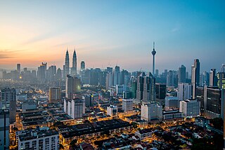
English: Kuala Lumpur is the national capital and most populous city in Malaysia. The city covers an area of 243 km2 and has an estimated population of 1.6 million as of 2010. Greater Kuala Lumpur, covering similar area as the Klang Valley, is an urban agglomeration of 7.5 million people as of 2012. It is among the fastest growing metropolitan regions in South-East Asia, in terms of population and economy.
Kuala Lumpur is the seat of the Parliament of Malaysia. The city was once home to the executive and judicial branches of the federal government, but they were moved to Putrajaya in early 1999. Some sections of the judiciary still remain in the capital city of Kuala Lumpur. The official residence of the Malaysian King, the Istana Negara, is also situated in Kuala Lumpur. Rated as an alpha world city, Kuala Lumpur is the cultural, financial and economic centre of Malaysia due to its position as the capital as well as being a key city. Kuala Lumpur was ranked 48th among global cities by Foreign Policy's 2010 Global Cities Index and was ranked 67th among global cities for economic and social innovation by the 2thinknow Innovation Cities Index in 2010. Since the 1990s, the city has played host to many international sporting, political and cultural events including the 1998 Commonwealth Games and the Formula One Grand Prix. In addition, Kuala Lumpur is home to the tallest twin buildings in the world, the Petronas Twin Towers, which have become an iconic symbol of Malaysia's futuristic development [Wikipedia.org] |
| วันที่ | |
| แหล่งที่มา | Kuala Lumpur at dawn |
| ผู้สร้างสรรค์ | Jorge Láscar from Melbourne, Australia |
| ตำแหน่งที่ตั้งกล้อง | | ภาพนี้และภาพอื่น ๆ ณ สถานที่เดียวกันที่ OpenStreetMap |
|---|
.jpg¶ms=003.156242_N_0101.713056_E_globe:Earth_type:camera_source:Flickr_&language=th)
การอนุญาตใช้สิทธิ
- คุณสามารถ:
- ที่จะแบ่งปัน – ที่จะทำสำเนา แจกจ่าย และส่งงานดังกล่าวต่อไป
- ที่จะเรียบเรียงใหม่ – ที่จะดัดแปลงงานดังกล่าว
- ภายใต้เงื่อนไขต่อไปนี้:
- แสดงที่มา – คุณต้องให้เกียรติเจ้าของงานอย่างเหมาะสม โดยเพิ่มลิงก์ไปยังสัญญาอนุญาต และระบุหากมีการเปลี่ยนแปลง คุณอาจทำเช่นนี้ได้ในรูปแบบใดก็ได้ตามควร แต่ต้องไม่ใช่ในลักษณะที่แนะว่าผู้ให้อนุญาตสนับสนุนคุณหรือการใช้งานของคุณ
| This image was originally posted to Flickr by Jorge Lascar at https://flickr.com/photos/8721758@N06/18794580599 (archive). It was reviewed on 2 กุมภาพันธ์ พ.ศ. 2561 by FlickreviewR 2 and was confirmed to be licensed under the terms of the cc-by-2.0. |
ประวัติไฟล์
คลิกวันที่/เวลาเพื่อดูไฟล์ที่ปรากฏในขณะนั้น
| วันที่/เวลา | รูปย่อ | ขนาด | ผู้ใช้ | ความเห็น | |
|---|---|---|---|---|---|
| ปัจจุบัน | 17:28, 2 กุมภาพันธ์ 2561 | | 7,360 × 4,912 (2.33 เมกะไบต์) | Thesupermat2 | Transferred from Flickr via Flickr2Commons |
หน้าที่มีภาพนี้
หน้าต่อไปนี้ โยงมาที่ภาพนี้:
การใช้ไฟล์ข้ามโครงการ
วิกิอื่นต่อไปนี้ใช้ไฟล์นี้:
- การใช้บน bn.wikipedia.org
- การใช้บน bo.wikipedia.org
- การใช้บน en.wikipedia.org
- Kuala Lumpur
- Kajang
- Demographics of Malaysia
- Geography of Malaysia
- Shah Alam
- George Town, Penang
- List of cities in Malaysia
- Ipoh
- Kota Kinabalu
- Johor Bahru
- Klang (city)
- Kuantan
- Petaling Jaya
- Sungai Petani
- Alor Setar
- Subang Jaya
- Malacca City
- Tawau
- Portal:Malaysia
- Seberang Perai
- Iskandar Puteri
- Malaysia
- Lists of cities by country
- Ampang Jaya
- Portal:Malaysia/Topics
- Selayang
- Template:Largest cities of Malaysia
- Seremban
- User:Joothis
- List of megalopolises
- การใช้บน fr.wikipedia.org
- การใช้บน hu.wikipedia.org
- การใช้บน id.wikipedia.org
- การใช้บน io.wikipedia.org
- การใช้บน ml.wikipedia.org
- การใช้บน no.wikipedia.org
- การใช้บน ta.wikipedia.org
- การใช้บน uk.wikipedia.org
- การใช้บน vi.wikipedia.org
ดูการใช้ข้ามโครงการเพิ่มเติมของไฟล์นี้
.jpg)
.jpg)