
ไฟล์:Ionian Islands.svg

ขนาดของตัวอย่าง PNG นี้ของไฟล์ SVG นี้: 532 × 547 พิกเซล ความละเอียดอื่น: 233 × 240 พิกเซล | 467 × 480 พิกเซล | 747 × 768 พิกเซล | 996 × 1,024 พิกเซล | 1,992 × 2,048 พิกเซล
ดูภาพที่มีความละเอียดสูงกว่า ((ไฟล์ SVG, 532 × 547 พิกเซล, ขนาดไฟล์: 281 กิโลไบต์))
| รูปภาพหรือไฟล์เสียงนี้ ต้นฉบับอยู่ที่ คอมมอนส์ รายละเอียดด้านล่าง เป็นข้อความที่แสดงผลจาก ไฟล์ต้นฉบับในคอมมอนส์
|

|
This map has been uploaded by Electionworld from en.wikipedia.org to enable the |
ความย่อ
| คำอธิบาย |
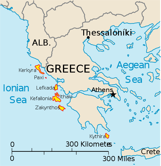
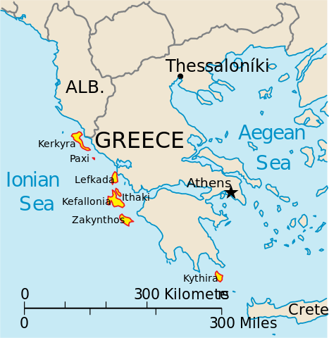
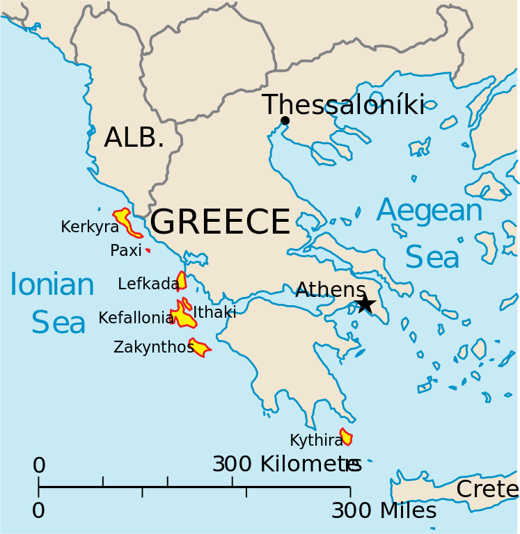
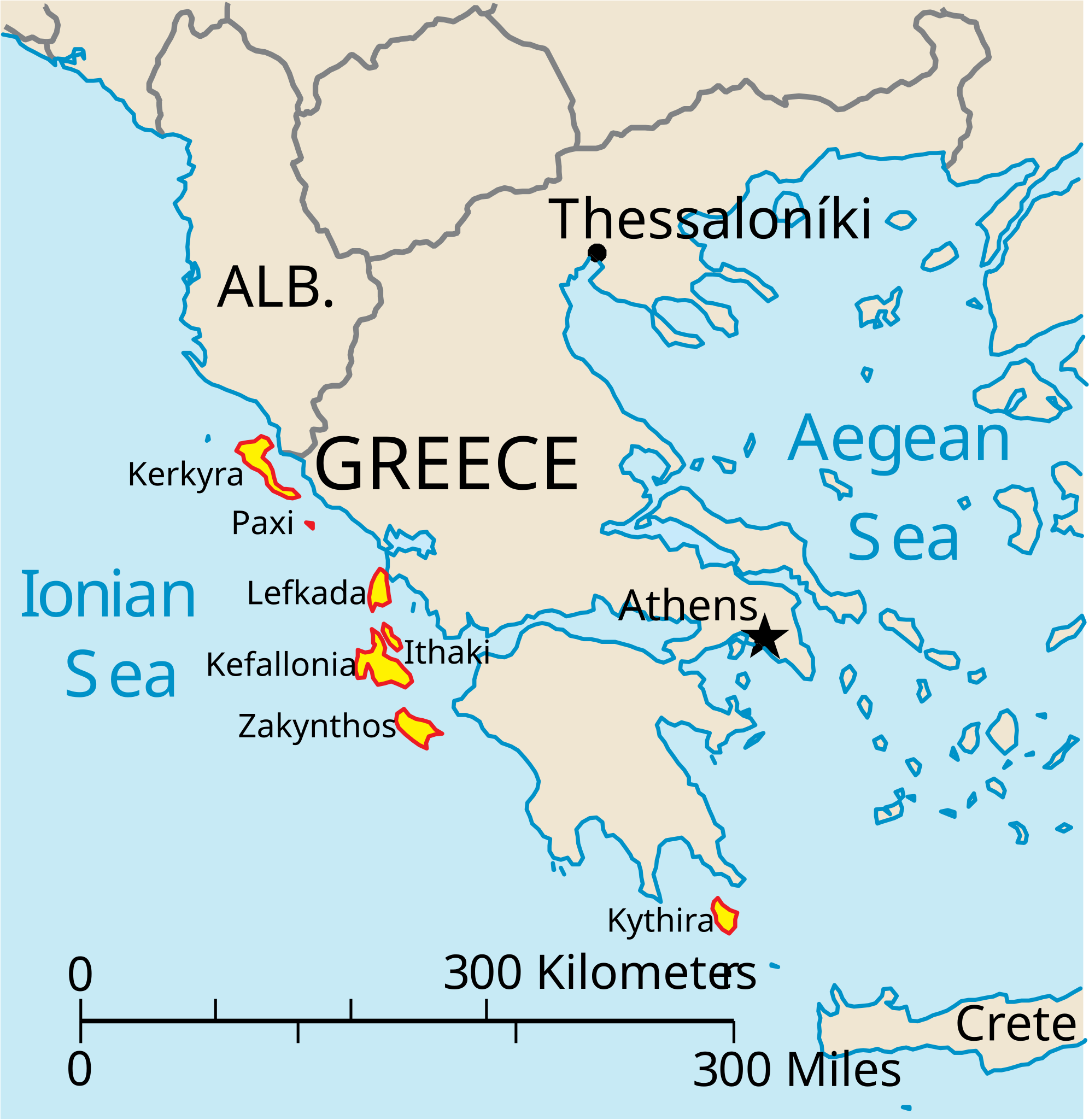
English: Map of the Ionian Islands off Greece. |
| วันที่ | |
| แหล่งที่มา | งานของตัว, Original vector data taken from the 2006 CIA World Factbook map of Europe. All modifications were made by me, and are free for anyone to use for any purpose. |
| ผู้สร้างสรรค์ | Electionworld |
| เวอร์ชันอื่น |
Version en français : |
การอนุญาตใช้สิทธิ
This image is in the public domain because it contains materials that originally came from the United States Central Intelligence Agency's World Factbook.
|
 |
ประวัติไฟล์
คลิกวันที่/เวลาเพื่อดูไฟล์ที่ปรากฏในขณะนั้น
| วันที่/เวลา | รูปย่อ | ขนาด | ผู้ใช้ | ความเห็น | |
|---|---|---|---|---|---|
| ปัจจุบัน | 21:39, 4 เมษายน 2553 | | 532 × 547 (281 กิโลไบต์) | Kmusser | rm Macedonia label, not important to the map and avoids POV issue |
| 03:17, 21 ธันวาคม 2549 |  | 532 × 547 (258 กิโลไบต์) | Electionworld | {{ew|en|IMeowbot}} == Summary == Map of the Ionian Islands off Greece. Original vector data taken from the 2006 CIA World Factbook map of Europe. All modifications were made by me, and are free for anyone to use for any purpose. == Licensing == {{PD-US |
หน้าที่มีภาพนี้
หน้าต่อไปนี้ โยงมาที่ภาพนี้:
การใช้ไฟล์ข้ามโครงการ
วิกิอื่นต่อไปนี้ใช้ไฟล์นี้:
- การใช้บน ar.wikipedia.org
- การใช้บน ast.wikipedia.org
- การใช้บน be.wikipedia.org
- การใช้บน bg.wikipedia.org
- การใช้บน ceb.wikipedia.org
- การใช้บน ce.wikipedia.org
- การใช้บน cy.wikipedia.org
- การใช้บน da.wikipedia.org
- การใช้บน de.wikipedia.org
- การใช้บน en.wikipedia.org
- การใช้บน et.wikipedia.org
- การใช้บน fa.wikipedia.org
- การใช้บน fi.wikipedia.org
- การใช้บน fr.wikipedia.org
- การใช้บน he.wikipedia.org
- การใช้บน hr.wikipedia.org
- การใช้บน hu.wikipedia.org
- การใช้บน hyw.wikipedia.org
- การใช้บน id.wikipedia.org
- การใช้บน it.wikipedia.org
ดูการใช้ข้ามโครงการเพิ่มเติมของไฟล์นี้