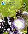
ไฟล์:Hurricane Andrew Landfall.jpg

ขนาดของตัวอย่างนี้: 502 × 600 พิกเซล ความละเอียดอื่น: 201 × 240 พิกเซล | 402 × 480 พิกเซล | 720 × 860 พิกเซล
ดูภาพที่มีความละเอียดสูงกว่า (720 × 860 พิกเซล, ขนาดไฟล์: 266 กิโลไบต์, ชนิดไมม์: image/jpeg)
ประวัติไฟล์
คลิกวันที่/เวลาเพื่อดูไฟล์ที่ปรากฏในขณะนั้น
| วันที่/เวลา | รูปย่อ | ขนาด | ผู้ใช้ | ความเห็น | |
|---|---|---|---|---|---|
| ปัจจุบัน | 06:31, 15 สิงหาคม 2549 |  | 720 × 860 (266 กิโลไบต์) | Nilfanion | {{Information| |Description= en:Hurricane Andrew landfalling in en:South Florida on en:August 24, en:1992, with winds of up to 165 miles per hour. |Source=Satellite image via [[:en:National Oceanic and Atmospheric Administration|NOAA] |
หน้าที่มีภาพนี้
หน้าต่อไปนี้ โยงมาที่ภาพนี้:
การใช้ไฟล์ข้ามโครงการ
วิกิอื่นต่อไปนี้ใช้ไฟล์นี้:
- การใช้บน ang.wikipedia.org
- การใช้บน bn.wikipedia.org
- การใช้บน en.wikipedia.org
- Wikipedia:Selected anniversaries/August 24
- User talk:Titoxd/Archive18
- Category:Tropical cyclone rainfall templates
- Category:Tropical cyclone templates
- User:Hurricanehink/Awards
- Category:Requests for tropical cyclone A-Class review
- Effects of Hurricane Andrew in Florida
- Wikipedia:Main Page history/2012 August 24
- การใช้บน fr.wikipedia.org
- การใช้บน it.wikipedia.org
- การใช้บน ms.wikipedia.org
- การใช้บน simple.wikipedia.org

