ไฟล์:Hammurabi's Babylonia 1.svg
ไม่รองรับเนื้อหาของหน้าในภาษาอื่น
จากวิกิพีเดีย สารานุกรมเสรี

ดูภาพที่มีความละเอียดสูงกว่า((ไฟล์ SVG, 655 × 570 พิกเซล, ขนาดไฟล์: 183 กิโลไบต์))

Wikimedia Commons logo รูปภาพหรือไฟล์เสียงนี้ ต้นฉบับอยู่ที่ คอมมอนส์ รายละเอียดด้านล่าง เป็นข้อความที่แสดงผลจาก ไฟล์ต้นฉบับในคอมมอนส์
คอมมอนส์เป็นเว็บไซต์ในโครงการสำหรับเก็บรวบรวมสื่อเสรี ที่ คุณสามารถช่วยได้
 
W3C-validity not checked.

ความย่อ

คำอธิบาย

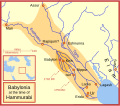
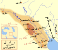
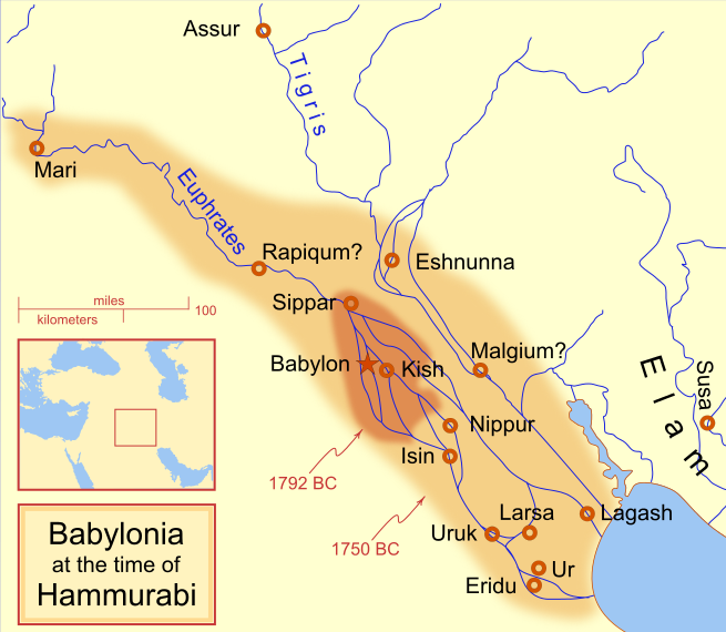
A locator map of Hammurabi's Babylonia, showing the Babylonian territory upon his ascension in 1792 BC and upon his death in 1750 BC. The river courses and coastline are those of that time period -- in general, they are not the modern rivers or coastlines. This is a Mercator projection, with north in its usual position

There is some question to what degree the cities of Nineveh, Tuttul, and Assur were under Babylonian authority. While in his introduction to his code of laws, Hammurabi claims lordship over these cities, Roaf does not include any of these in his map, upon which this map is based, and Chevalas states that "Assur and Nineveh were held for a very few years" (p. 155). Therefore, I have not included them as under Hammurabi's control in 1750 BC.
วันที่
แหล่งที่มา งานของตัว
ผู้สร้างสรรค์ MapMaster
เวอร์ชันอื่น

[แก้ไข]

See also

References

  • Bjorklund, Oddvar; Holmboe, Haakon; Rohr, Anders (1970) Historical Atlas of the World, Barnes & Noble, NY, SBN: 389-00253-4.
  • Chavalas, Mark W.; K. Lawson Younger (2003) Mesopotamia and the Bible, Continuum International Publishing Group, ISBN 978-0567082312.
  • Hammond World Atlas Corporation (2007) Historical World Atlas, ISBN 9-780843-71391-6
  • Roaf, M. (1990) Cultural Atlas of Mesopotamia and the ancient Near East, Oxford: Facts on File. (In general, the basis for the ancient river courses and ancient coastline).
  • Van De Mieroop, Marc (2005). King Hammurabi of Babylon: A Biography. Blackwell Publishing. ISBN 1405126604

การอนุญาตใช้สิทธิ

ข้าพเจ้า ในฐานะผู้ถือลิขสิทธิ์ของภาพหรือสื่อนี้ อนุญาตให้ใช้ภาพหรือสื่อนี้ภายใต้เงื่อนไขต่อไปนี้
GNU head อนุญาตให้คัดลอก แจกจ่ายและ/หรือดัดแปรเอกสารนี้ภายใต้เงื่อนไขของสัญญาอนุญาตเอกสารเสรีของกนู รุ่น 1.2 หรือรุ่นใด ๆ นับจากนี้ที่ออกโดยมูลนิธิซอฟต์แวร์เสรี โดยไม่มีส่วนใดห้ามแก้ไข ไม่มีข้อความปกหน้าและปกหลัง สำเนาของสัญญาอนุญาตรวมอยู่ในส่วนชื่อ สัญญาอนุญาตเอกสารเสรีของกนู
w:th:ครีเอทีฟคอมมอนส์
แสดงที่มา อนุญาตแบบเดียวกัน
This file is licensed under the Creative Commons Attribution-Share Alike 4.0 International, 3.0 Unported, 2.5 Generic, 2.0 Generic and 1.0 Generic license.
คุณสามารถ:
  • ที่จะแบ่งปัน – ที่จะทำสำเนา แจกจ่าย และส่งงานดังกล่าวต่อไป
  • ที่จะเรียบเรียงใหม่ – ที่จะดัดแปลงงานดังกล่าว
ภายใต้เงื่อนไขต่อไปนี้:
  • แสดงที่มา – คุณต้องให้เกียรติเจ้าของงานอย่างเหมาะสม โดยเพิ่มลิงก์ไปยังสัญญาอนุญาต และระบุหากมีการเปลี่ยนแปลง คุณอาจทำเช่นนี้ได้ในรูปแบบใดก็ได้ตามควร แต่ต้องไม่ใช่ในลักษณะที่แนะว่าผู้ให้อนุญาตสนับสนุนคุณหรือการใช้งานของคุณ
  • อนุญาตแบบเดียวกัน – หากคุณดัดแปลง เปลี่ยนรูป หรือต่อเติมงานนี้ คุณต้องใช้สัญญาอนุญาตแบบเดียวกันหรือแบบที่เหมือนกับสัญญาอนุญาตที่ใช้กับงานนี้เท่านั้น
คุณสามารถเลือกสัญญาอนุญาตดังกล่าวตามต้องการ

คำบรรยายโดยย่อ

เพิ่มคำบรรยายทรรทัดเดียวเพื่อขยายความว่าไฟล์นี้มีอะไร
Babylonian

ไอเทมที่แสดงอยู่ในไฟล์นี้

ประกอบด้วย

MIME type อังกฤษ

image/svg+xml

ประวัติไฟล์

คลิกวันที่/เวลาเพื่อดูไฟล์ที่ปรากฏในขณะนั้น

(ล่าสุด | เก่าสุด) ดู (ใหม่กว่า 10 | ) (10 | 20 | 50 | 100 | 250 | 500)
วันที่/เวลารูปย่อขนาดผู้ใช้ความเห็น
ปัจจุบัน16:14, 21 เมษายน 2556รูปย่อสำหรับรุ่นเมื่อ 16:14, 21 เมษายน 2556655 × 570 (183 กิโลไบต์)CitypeekCleanup of file. Valid SVG now.
02:06, 28 เมษายน 2553รูปย่อสำหรับรุ่นเมื่อ 02:06, 28 เมษายน 2553655 × 570 (168 กิโลไบต์)DieBucheremoved border
22:05, 30 กรกฎาคม 2552รูปย่อสำหรับรุ่นเมื่อ 22:05, 30 กรกฎาคม 2552661 × 580 (317 กิโลไบต์)Amit6Some nodes changed.
06:24, 4 มีนาคม 2551รูปย่อสำหรับรุ่นเมื่อ 06:24, 4 มีนาคม 2551661 × 580 (163 กิโลไบต์)MapMasterAdded city-state, moved Sippar, minor other changes based on recent Kassite map
23:06, 23 กุมภาพันธ์ 2551รูปย่อสำหรับรุ่นเมื่อ 23:06, 23 กุมภาพันธ์ 2551661 × 580 (161 กิโลไบต์)MapMasterAdded 1 city, added name for 1 city
10:29, 21 กุมภาพันธ์ 2551รูปย่อสำหรับรุ่นเมื่อ 10:29, 21 กุมภาพันธ์ 2551661 × 580 (159 กิโลไบต์)MapMaster"blurred" the territory outlines
06:25, 21 กุมภาพันธ์ 2551รูปย่อสำหรับรุ่นเมื่อ 06:25, 21 กุมภาพันธ์ 2551661 × 580 (155 กิโลไบต์)MapMasterChanges made based on info from ''Mesopotamia and the Bible''
09:03, 19 กุมภาพันธ์ 2551รูปย่อสำหรับรุ่นเมื่อ 09:03, 19 กุมภาพันธ์ 2551663 × 580 (156 กิโลไบต์)MapMasterFixed an error on my part
04:12, 19 กุมภาพันธ์ 2551รูปย่อสำหรับรุ่นเมื่อ 04:12, 19 กุมภาพันธ์ 2551332 × 292 (156 กิโลไบต์)MapMastersome minor edits
02:19, 19 กุมภาพันธ์ 2551รูปย่อสำหรับรุ่นเมื่อ 02:19, 19 กุมภาพันธ์ 2551332 × 293 (154 กิโลไบต์)MapMasterremoved unrenderable bmp
(ล่าสุด | เก่าสุด) ดู (ใหม่กว่า 10 | ) (10 | 20 | 50 | 100 | 250 | 500)

หน้าต่อไปนี้ โยงมาที่ภาพนี้:

การใช้ไฟล์ข้ามโครงการ

วิกิอื่นต่อไปนี้ใช้ไฟล์นี้:

ดูการใช้ข้ามโครงการเพิ่มเติมของไฟล์นี้

ข้อมูลเกี่ยวกับภาพ