
ไฟล์:Groundwater zone.png
ไม่มีภาพที่มีรายละเอียดสูงกว่านี้
Groundwater_zone.png (535 × 303 พิกเซล, ขนาดไฟล์: 108 กิโลไบต์, ชนิดไมม์: image/png)
| รูปภาพหรือไฟล์เสียงนี้ ต้นฉบับอยู่ที่ คอมมอนส์ รายละเอียดด้านล่าง เป็นข้อความที่แสดงผลจาก ไฟล์ต้นฉบับในคอมมอนส์
|
ความย่อ
| คำอธิบาย |
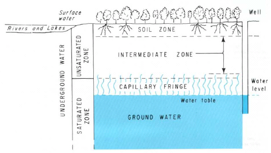
ไทย: น้ำใต้ดินแบ่งออกเป็น 3 โซนได้แก่ soil zone, intermediate zone และ the upper part of capillary fringe |
| แหล่งที่มา | https://pubs.er.usgs.gov/ |
| ผู้สร้างสรรค์ | Heath, Ralph C. |
การอนุญาตใช้สิทธิ
This image is in the public domain in the United States because it only contains materials that originally came from the United States Geological Survey, an agency of the United States Department of the Interior. For more information, see the official USGS copyright policy.
|
ประวัติไฟล์
คลิกวันที่/เวลาเพื่อดูไฟล์ที่ปรากฏในขณะนั้น
| วันที่/เวลา | รูปย่อ | ขนาด | ผู้ใช้ | ความเห็น | |
|---|---|---|---|---|---|
| ปัจจุบัน | 15:50, 22 กุมภาพันธ์ 2554 | | 535 × 303 (108 กิโลไบต์) | Tanitha | {{Information |Description ={{th|1=น้ำใต้ดินแบ่งออกเป็น 3 โซนได้แก่ soil zone, intermediate zone และ the upper part of capillary fringe}} |Source =http://pubs.er.usgs.gov/ |Author |
หน้าที่มีภาพนี้
หน้าต่อไปนี้ โยงมาที่ภาพนี้:
การใช้ไฟล์ข้ามโครงการ
วิกิอื่นต่อไปนี้ใช้ไฟล์นี้:
- การใช้บน hr.wikipedia.org
- การใช้บน sl.wikipedia.org