
ไฟล์:Greater London in England (wo City of London) (zoom).svg

ขนาดของตัวอย่าง PNG นี้ของไฟล์ SVG นี้: 494 × 600 พิกเซล ความละเอียดอื่น: 198 × 240 พิกเซล | 395 × 480 พิกเซล | 632 × 768 พิกเซล | 843 × 1,024 พิกเซล | 1,686 × 2,048 พิกเซล | 816 × 991 พิกเซล
ดูภาพที่มีความละเอียดสูงกว่า ((ไฟล์ SVG, 816 × 991 พิกเซล, ขนาดไฟล์: 1.32 เมกะไบต์))
| รูปภาพหรือไฟล์เสียงนี้ ต้นฉบับอยู่ที่ คอมมอนส์ รายละเอียดด้านล่าง เป็นข้อความที่แสดงผลจาก ไฟล์ต้นฉบับในคอมมอนส์
|
ความย่อ
| คำอธิบาย |
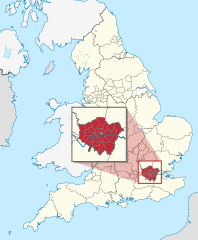
Deutsch: Lage der zeremoniellen Grafschaft XY (siehe Dateiname) inmitten der nicht-zeremoniellen Verwaltungsgliederung in England. (Rot markiert ist also das Gebiet einer zeremoniellen Grafschaft. Eingezeichnet sind also innerhalb Englands nur die Grenze der Regionen, der ländlichen Grafschaften, der städtischen Bezirke als Teilgebiete der städtischen Grafschaften, der Bezirke Londons, und der Gebiete der einstufigen Verwaltungen.)
English: Location of ceremonial county xy (see filename) within non-ceremonial administrative divisions in England. (Hence, within England, the maps shows only borders of regions, of non-metropolitan counties, of metropolitan boroughs (i.e. subdivisions of metropolitan counties), of the areas of unitary authorities and of the London boroughs.) |
||||
| วันที่ | |||||
| แหล่งที่มา |
งานของตัว ไฟล์ภาพกราฟิกส์เวกเตอร์ไม่ได้ระบุการตรวจโดย W3C นี้ สร้างขึ้นโดยใช้ Adobe Illustrator This SVG file was uploaded with Commonist. This vector image includes elements that have been taken or adapted from this file: This vector image includes elements that have been taken or adapted from this file: |
||||
| ผู้สร้างสรรค์ |
TUBS |
||||
| เวอร์ชันอื่น |
|
||||
.svg)
.svg)
.svg)
.svg)
.svg)
.svg)
.svg)

-en.svg)

.svg)
.svg)
.svg)

_(US48).svg)
_(small_islands_magnified)_(-mini_map_-rivers).svg)
.svg)
_(extra_close)_(US48).svg)
.svg)
_(zoom).svg)

.svg)


_(UNMIK).svg)
.svg)
_(disputed_hatched).svg)
_(claimed_and_disputed_hatched).svg)
.svg)
.svg)
_(%2Ball_claims_hatched).svg)

.svg)
_(shade).svg)
_(shade)_(special_marker).svg)
_(-mini_map).svg)
_(-mini_map).svg)
_(-mini_map).svg)


.svg)

.svg)
_(zoom).svg)
การอนุญาตใช้สิทธิ
ข้าพเจ้า ในฐานะผู้ถือลิขสิทธิ์ของภาพหรือสื่อนี้ อนุญาตให้ใช้ภาพหรือสื่อนี้ภายใต้เงื่อนไขต่อไปนี้
ไฟล์นี้อยู่ภายใต้สัญญาอนุญาต ครีเอทีฟคอมมอนส์ แบบแสดงที่มา-อนุญาตแบบเดียวกัน 3.0 ต้นฉบับ
- คุณสามารถ:
- ที่จะแบ่งปัน – ที่จะทำสำเนา แจกจ่าย และส่งงานดังกล่าวต่อไป
- ที่จะเรียบเรียงใหม่ – ที่จะดัดแปลงงานดังกล่าว
- ภายใต้เงื่อนไขต่อไปนี้:
- แสดงที่มา – คุณต้องให้เกียรติเจ้าของงานอย่างเหมาะสม โดยเพิ่มลิงก์ไปยังสัญญาอนุญาต และระบุหากมีการเปลี่ยนแปลง คุณอาจทำเช่นนี้ได้ในรูปแบบใดก็ได้ตามควร แต่ต้องไม่ใช่ในลักษณะที่แนะว่าผู้ให้อนุญาตสนับสนุนคุณหรือการใช้งานของคุณ
- อนุญาตแบบเดียวกัน – หากคุณดัดแปลง เปลี่ยนรูป หรือต่อเติมงานนี้ คุณต้องใช้สัญญาอนุญาตแบบเดียวกันหรือแบบที่เหมือนกับสัญญาอนุญาตที่ใช้กับงานนี้เท่านั้น

|
I'd greatly appreciate, that you attribute this media file to Wikimedia Commons, if used outside Wikipedia or Commons. For use in publications such as books, newspapers, blogs, websites, please insert here the following line:
|
_(zoom).svg&action=edit&redlink=1)
ประวัติไฟล์
คลิกวันที่/เวลาเพื่อดูไฟล์ที่ปรากฏในขณะนั้น
| วันที่/เวลา | รูปย่อ | ขนาด | ผู้ใช้ | ความเห็น | |
|---|---|---|---|---|---|
| ปัจจุบัน | 04:48, 29 พฤศจิกายน 2554 | | 816 × 991 (1.32 เมกะไบต์) | TUBS |
หน้าที่มีภาพนี้
หน้าต่อไปนี้ โยงมาที่ภาพนี้:
การใช้ไฟล์ข้ามโครงการ
วิกิอื่นต่อไปนี้ใช้ไฟล์นี้:
- การใช้บน az.wikipedia.org
- การใช้บน en.wikipedia.org
- การใช้บน fa.wikipedia.org
- การใช้บน he.wikipedia.org
- การใช้บน ja.wikipedia.org
- การใช้บน ko.wikipedia.org
- การใช้บน ms.wikipedia.org
- การใช้บน no.wikipedia.org
- การใช้บน pnb.wikipedia.org
- การใช้บน qu.wikipedia.org
- การใช้บน tum.wikipedia.org
- การใช้บน uk.wikipedia.org
- การใช้บน ur.wikipedia.org
_(zoom).svg)