
ไฟล์:Georgia high detail map.png

ดูภาพที่มีความละเอียดสูงกว่า (2,529 × 1,872 พิกเซล, ขนาดไฟล์: 340 กิโลไบต์, ชนิดไมม์: image/png)
| รูปภาพหรือไฟล์เสียงนี้ ต้นฉบับอยู่ที่ คอมมอนส์ รายละเอียดด้านล่าง เป็นข้อความที่แสดงผลจาก ไฟล์ต้นฉบับในคอมมอนส์
|

|
ภาพแผนที่นี้ ควรจะถูกสร้างใหม่เป็นกราฟิกส์เวกเตอร์ ซึ่งมีข้อดีอีกหลายประการ ดูเพิ่มเติมที่คอมมอนส์:สื่อต้องการเก็บกวาดสำหรับสารสนเทศเพิ่มเติม หากภาพนี้มีในรูปแบบกราฟิกส์เวกเตอร์อยู่แล้ว กรุณาอัปโหลดและแทนที่แม่แบบนี้ด้วย
{{vector version available|ชื่อภาพใหม่}}
แนะนำเป็นอย่างยิ่งให้ตั้งชื่อไฟล์เวกเตอร์ใหม่นั้นในรูปแบบ "Georgia high detail map.svg" แล้วใส่แม่แบบ Vector version available (หรือ Vva) ซึ่งไม่ต้องใช้พารามิเตอร์ ชื่อภาพใหม่ |
ความย่อ
| คำอธิบาย |
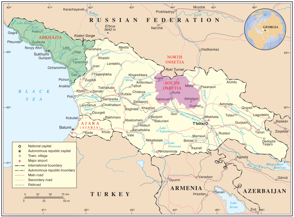
English: Map of Georgia showing the autonomous republics of Abkhazia (de facto independent) and Adjaria, and the de facto independent region of South Ossetia. |
|||
| วันที่ | ||||
| แหล่งที่มา | United Nations Cartographic Section, Original unmodified map is at http://www.un.org/Depts/Cartographic/map/profile/georgia.pdf. | |||
| ผู้สร้างสรรค์ | United Nations Cartographic Section, with amendments by User:ChrisO | |||
| การอนุญาต (การใช้ไฟล์นี้ใหม่) |
Public domain | |||
| เวอร์ชันอื่น |
|


| This image is a map derived from a United Nations map.
Unless stated otherwise, UN maps are to be considered in the public domain. This applies worldwide. UN maps are, in principle, open source material and you can use them in your work or for making your own map. UN requests however that you delete the UN name, logo and reference number upon any modification to the map. Content of your map will be your responsibility. You can state in your publication, if you wish, something like: based on UN map … (map name, map number, revision number and date). See: Geospatial Information Section. And: Geospatial, location data for a better world. |
 |
การอนุญาตใช้สิทธิ
| ข้าพเจ้า ผู้ถือลิขสิทธิ์ในงานนี้ ขอมอบงานให้เป็นสาธารณสมบัติ ประกาศนี้มีผลทั่วโลก ในบางประเทศ การกระทำดังกล่าวอาจไม่สามารถทำได้ตามกฎหมาย ข้าพเจ้าอนุญาตให้ทุกคนมีสิทธิ์ในการใช้ไฟล์นี้ในทุกเหตุผลการใช้ โดยไม่มีมีเงื่อนไข เว้นแต่กฎหมายไม่อนุญาตให้ทำเช่นนั้น |
ประวัติไฟล์
คลิกวันที่/เวลาเพื่อดูไฟล์ที่ปรากฏในขณะนั้น
| วันที่/เวลา | รูปย่อ | ขนาด | ผู้ใช้ | ความเห็น | |
|---|---|---|---|---|---|
| ปัจจุบัน | 18:35, 11 มกราคม 2552 | | 2,529 × 1,872 (340 กิโลไบต์) | Bestalex | {{Information |Description= |Source= |Date= |Author= |Permission= |other_versions= }} |
| 03:51, 13 สิงหาคม 2551 |  | 2,529 × 1,872 (330 กิโลไบต์) | ChrisO | ||
| 02:12, 13 สิงหาคม 2551 |  | 2,529 × 1,872 (331 กิโลไบต์) | ChrisO | {{Information |Description={{en|1=Map of Georgia showing the autonomous republics of Abkhazia and Adjaria, and the breakaway region of South Ossetia. Original unmodified map is at http://www.un.org/Depts/Cartographic/map/profile/georgia.pdf . }} |Source=U |
หน้าที่มีภาพนี้
หน้าต่อไปนี้ โยงมาที่ภาพนี้:
การใช้ไฟล์ข้ามโครงการ
วิกิอื่นต่อไปนี้ใช้ไฟล์นี้:
- การใช้บน af.wikipedia.org
- การใช้บน ar.wikipedia.org
- การใช้บน azb.wikipedia.org
- การใช้บน az.wikipedia.org
- การใช้บน az.wiktionary.org
- การใช้บน bn.wikipedia.org
- การใช้บน bxr.wikipedia.org
- การใช้บน ca.wikipedia.org
- การใช้บน cs.wikipedia.org
- การใช้บน cy.wikipedia.org
- การใช้บน el.wikipedia.org
- การใช้บน en.wikipedia.org
- Georgia (country)
- South Ossetia
- Georgian–Ossetian conflict
- Roki Tunnel
- Kosovo independence precedent
- Outline of Abkhazia
- Abkhazia
- Talk:Georgia (country)/Archive 5
- User:Kazkaskazkasako/Books/History
- Georgia–Russia border
- Wikipedia:Graphics Lab/Map workshop/Archive/Jul 2014
- User:Mschiffler/sandbox1
- Water supply and sanitation in Georgia
- Proposed Russian annexation of South Ossetia
- User:Royal Georgian/sandbox
- การใช้บน eo.wikipedia.org
- การใช้บน es.wikipedia.org
- การใช้บน et.wikipedia.org
- การใช้บน fa.wikipedia.org
- การใช้บน fi.wikipedia.org
- การใช้บน fi.wikivoyage.org
ดูการใช้ข้ามโครงการเพิ่มเติมของไฟล์นี้