
ไฟล์:France départementale.svg

ดูภาพที่มีความละเอียดสูงกว่า ((ไฟล์ SVG, 2,000 × 1,898 พิกเซล, ขนาดไฟล์: 1.87 เมกะไบต์))
| รูปภาพหรือไฟล์เสียงนี้ ต้นฉบับอยู่ที่ คอมมอนส์ รายละเอียดด้านล่าง เป็นข้อความที่แสดงผลจาก ไฟล์ต้นฉบับในคอมมอนส์
|
ความย่อ
| คำอธิบาย |
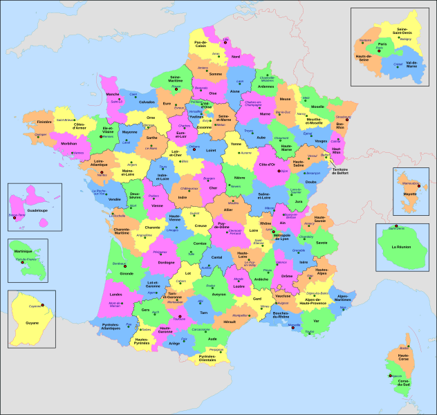
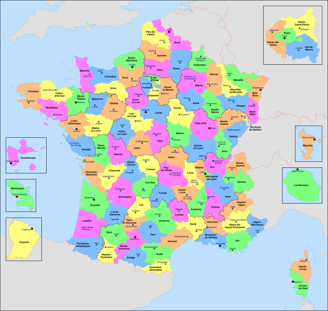
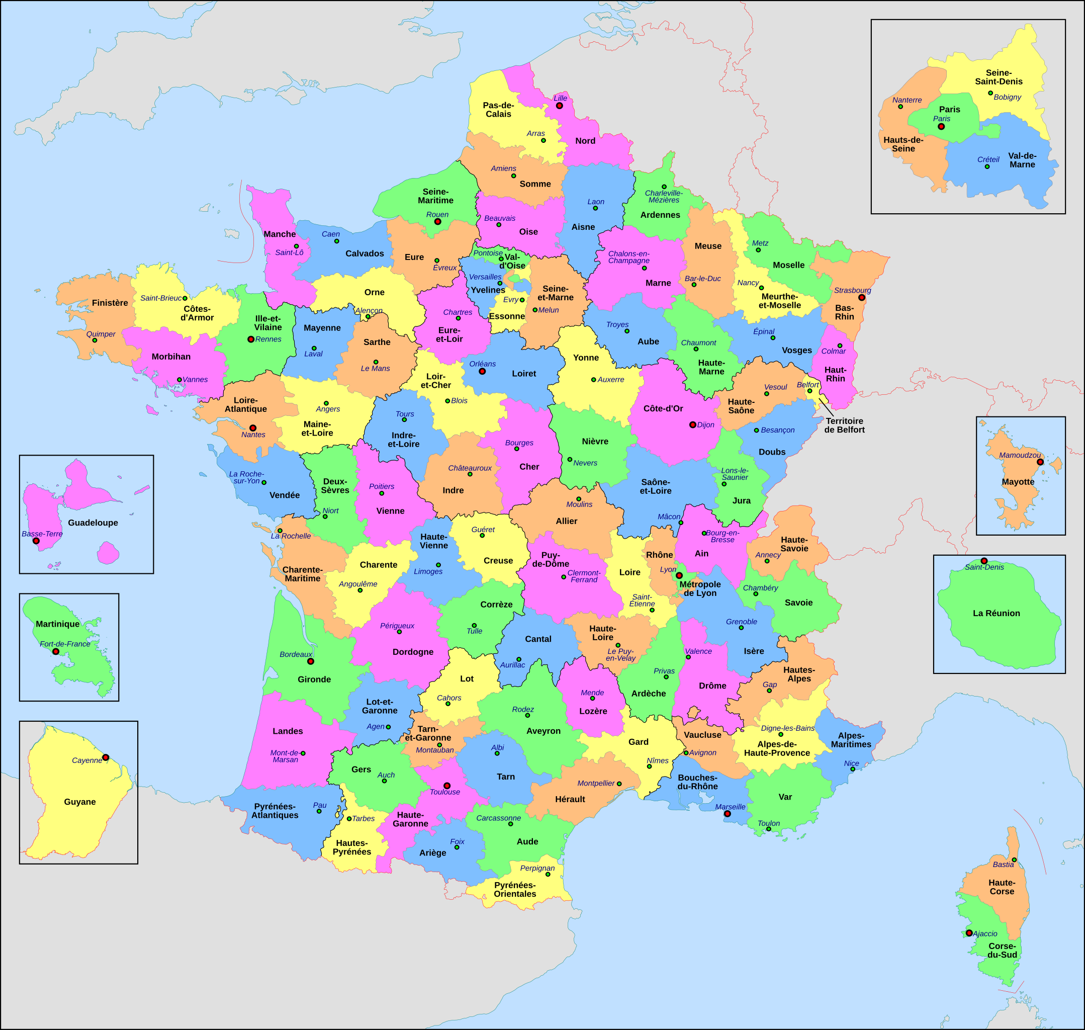
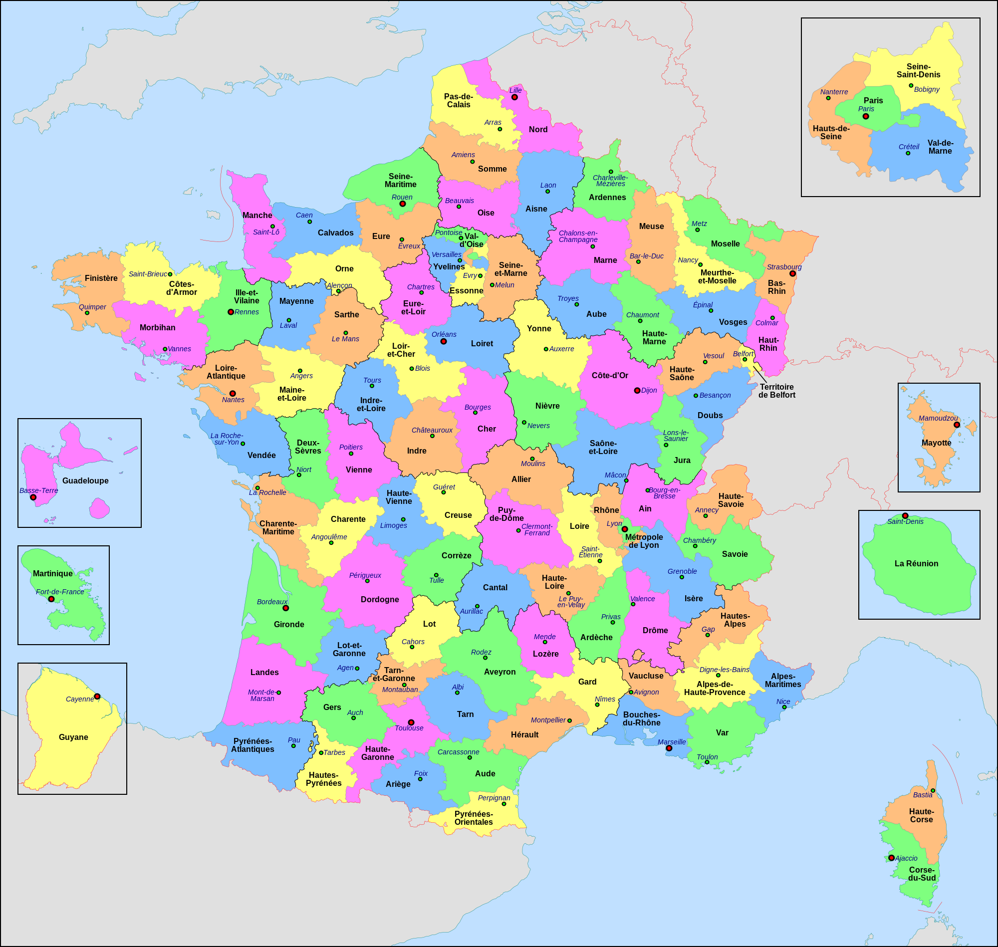
Français : Carte administrative de la France, créée sous Inkscape 0.47 à partir de plusieurs cartes (notamment celle-ci) créées par Sting.
Le fichier comporte vingt-quatre calques : Cadre, Chef-lieux de région, Villes, Chef-lieux de département, Numéros de département, Noms des régions, Nom des départements, **Encarts Départements d'Outre-Mer, **Encart Paris-Petite-Couronne, Coordonnées, Échelle et Mini-carte, Frontières internationales, Côtes, Limites régionales, Limites départementales, Lacs, Fleuves, *Régions métropolitaines, *Départements métropolitains, Terres françaises, Terres étrangères, Mers et océans, Échelle altimétrique, Topographie.
English: Administrative map of France, created under Inkscape 0.47 from several of the maps (especially this one) created by Sting.
The file consists of twenty-four layers: Frame, Administrative Centres of Regions, Towns, Administrative Centres of Departments, Numbers of Departments, Names of Regions, Names of Departments, **Overseas Departements Insets, **Paris Conurbation Inset, Coordinates, Scale and Mini-map, International boundaries, Coasts, Regional boundaries, Departmental boundaries, Lakes, Rivers, *Metropolitan Regions, *Metropolitan Departments, French lands, Foreign lands, Seas and Oceans, Altimetric Scale, Topography.
|
| วันที่ | |
| แหล่งที่มา | งานของตัว |
| ผู้สร้างสรรค์ | Nilstilar |
| เวอร์ชันอื่น |
|
| SVG genesis |


การอนุญาตใช้สิทธิ
- คุณสามารถ:
- ที่จะแบ่งปัน – ที่จะทำสำเนา แจกจ่าย และส่งงานดังกล่าวต่อไป
- ที่จะเรียบเรียงใหม่ – ที่จะดัดแปลงงานดังกล่าว
- ภายใต้เงื่อนไขต่อไปนี้:
- แสดงที่มา – คุณต้องให้เกียรติเจ้าของงานอย่างเหมาะสม โดยเพิ่มลิงก์ไปยังสัญญาอนุญาต และระบุหากมีการเปลี่ยนแปลง คุณอาจทำเช่นนี้ได้ในรูปแบบใดก็ได้ตามควร แต่ต้องไม่ใช่ในลักษณะที่แนะว่าผู้ให้อนุญาตสนับสนุนคุณหรือการใช้งานของคุณ
- อนุญาตแบบเดียวกัน – หากคุณดัดแปลง เปลี่ยนรูป หรือต่อเติมงานนี้ คุณต้องใช้สัญญาอนุญาตแบบเดียวกันหรือแบบที่เหมือนกับสัญญาอนุญาตที่ใช้กับงานนี้เท่านั้น
This image is used on a user page of a Wikimedia user and is stored on Commons according to the rules set out in Commons:Project scope#File in use on Commons only: the uploading of small numbers of images (e.g. of yourself) for use on a personal Commons user page is allowed or Commons:Project scope#File in use in another Wikimedia project: the uploading of small numbers of images (e.g. of yourself) for use on a personal user page of another project is allowed as long as that user is or was an active participant on that project.
If the image ceases to be used it may be eligible for deletion as it may have no educational purpose.
ประวัติไฟล์
คลิกวันที่/เวลาเพื่อดูไฟล์ที่ปรากฏในขณะนั้น
| วันที่/เวลา | รูปย่อ | ขนาด | ผู้ใช้ | ความเห็น | |
|---|---|---|---|---|---|
| ปัจจุบัน | 03:29, 23 มิถุนายน 2565 | | 2,000 × 1,898 (1.87 เมกะไบต์) | OpesMentis | Added hyphens on departments' names and towns' names and fixed "Réunion" to "La Réunion" |
| 01:10, 10 พฤศจิกายน 2564 |  | 2,000 × 1,898 (1.87 เมกะไบต์) | Puck04 | fixed SVG code (was "W3C-invalid") + cleanup using text editor; contains some invisible pathes | |
| 07:40, 1 พฤษภาคม 2563 |  | 2,000 × 1,898 (4.7 เมกะไบต์) | ChrisPtDe | File uploaded using svgtranslate tool (https://tools.wmflabs.org/svgtranslate/). Added translation for frp. | |
| 05:17, 29 เมษายน 2563 |  | 2,000 × 1,898 (4.7 เมกะไบต์) | ChrisPtDe | File uploaded using svgtranslate tool (https://tools.wmflabs.org/svgtranslate/). Added translation for frp. | |
| 05:56, 26 เมษายน 2563 |  | 2,000 × 1,898 (4.68 เมกะไบต์) | ChrisPtDe | File uploaded using svgtranslate tool (https://tools.wmflabs.org/svgtranslate/). Added translation for frp. | |
| 21:13, 4 พฤศจิกายน 2561 |  | 2,000 × 1,898 (4.55 เมกะไบต์) | Nilstilar | Corse "réunifiée" pose problème | |
| 19:05, 4 พฤศจิกายน 2561 |  | 2,000 × 1,898 (4.54 เมกะไบต์) | Nilstilar | Corse "réunifiée" (collectivité territoriale unique — département & région — au 1/1/2018) | |
| 20:01, 15 ตุลาคม 2561 |  | 2,000 × 1,898 (4.55 เมกะไบต์) | Nilstilar | Reverted to version as of 18:52, 10 May 2017 (UTC) | |
| 05:30, 29 ธันวาคม 2560 |  | 2,000 × 1,898 (2.24 เมกะไบต์) | Ras67 | frame removed, all invisible data stripped | |
| 01:52, 11 พฤษภาคม 2560 |  | 2,000 × 1,898 (4.55 เมกะไบต์) | Nilstilar | Rétablissement des limites régionales (au 01/10/2016) |
หน้าที่มีภาพนี้
หน้าต่อไปนี้ โยงมาที่ภาพนี้:
การใช้ไฟล์ข้ามโครงการ
วิกิอื่นต่อไปนี้ใช้ไฟล์นี้:
- การใช้บน ar.wikipedia.org
- การใช้บน arz.wikipedia.org
- การใช้บน ast.wikipedia.org
- การใช้บน ast.wiktionary.org
- การใช้บน az.wikipedia.org
- การใช้บน bg.wikipedia.org
- การใช้บน br.wikipedia.org
- การใช้บน ca.wikipedia.org
- การใช้บน cy.wikipedia.org
- การใช้บน el.wikipedia.org
- การใช้บน en.wikipedia.org
- การใช้บน es.wikipedia.org
- การใช้บน eu.wikipedia.org
- การใช้บน fr.wikipedia.org
- Département français
- Monument historique (France)
- Géographie de la Guadeloupe
- Économie de la Guadeloupe
- Transports en France
- Liste des ponts de Paris
- Géographie de la Drôme
- Liste des anciennes communes du Loiret
- Économie de La Réunion
- Politique dans la Haute-Vienne
- Politique dans la Creuse
- Climat des Yvelines
- Géographie du Territoire de Belfort
- Culture en Guyane
- Économie du Puy-de-Dôme
- Géographie de la Charente-Maritime
- Économie de l'Oise
- Économie de la Haute-Savoie
- Climat de l'Aveyron
- Climat du Bas-Rhin
- Climat du Haut-Rhin
- Géographie du Loiret
- Arboretum de Balaine
- Transports dans la métropole de Lyon
- Économie de la Haute-Saône
- Climat du Finistère
- Politique à La Réunion
- Géographie d'Eure-et-Loir
- Transport en Corse
- Liste des musées de Paris
ดูการใช้ข้ามโครงการเพิ่มเติมของไฟล์นี้