
ไฟล์:East of England counties 2019 map.jpg
ขนาดของตัวอย่างนี้: 573 × 599 พิกเซล ความละเอียดอื่น: 229 × 240 พิกเซล | 459 × 480 พิกเซล | 734 × 768 พิกเซล | 979 × 1,024 พิกเซล | 1,958 × 2,048 พิกเซล | 5,042 × 5,275 พิกเซล
ดูภาพที่มีความละเอียดสูงกว่า (5,042 × 5,275 พิกเซล, ขนาดไฟล์: 873 กิโลไบต์, ชนิดไมม์: image/jpeg)
| รูปภาพหรือไฟล์เสียงนี้ ต้นฉบับอยู่ที่ คอมมอนส์ รายละเอียดด้านล่าง เป็นข้อความที่แสดงผลจาก ไฟล์ต้นฉบับในคอมมอนส์
|
ความย่อ
| คำอธิบาย |
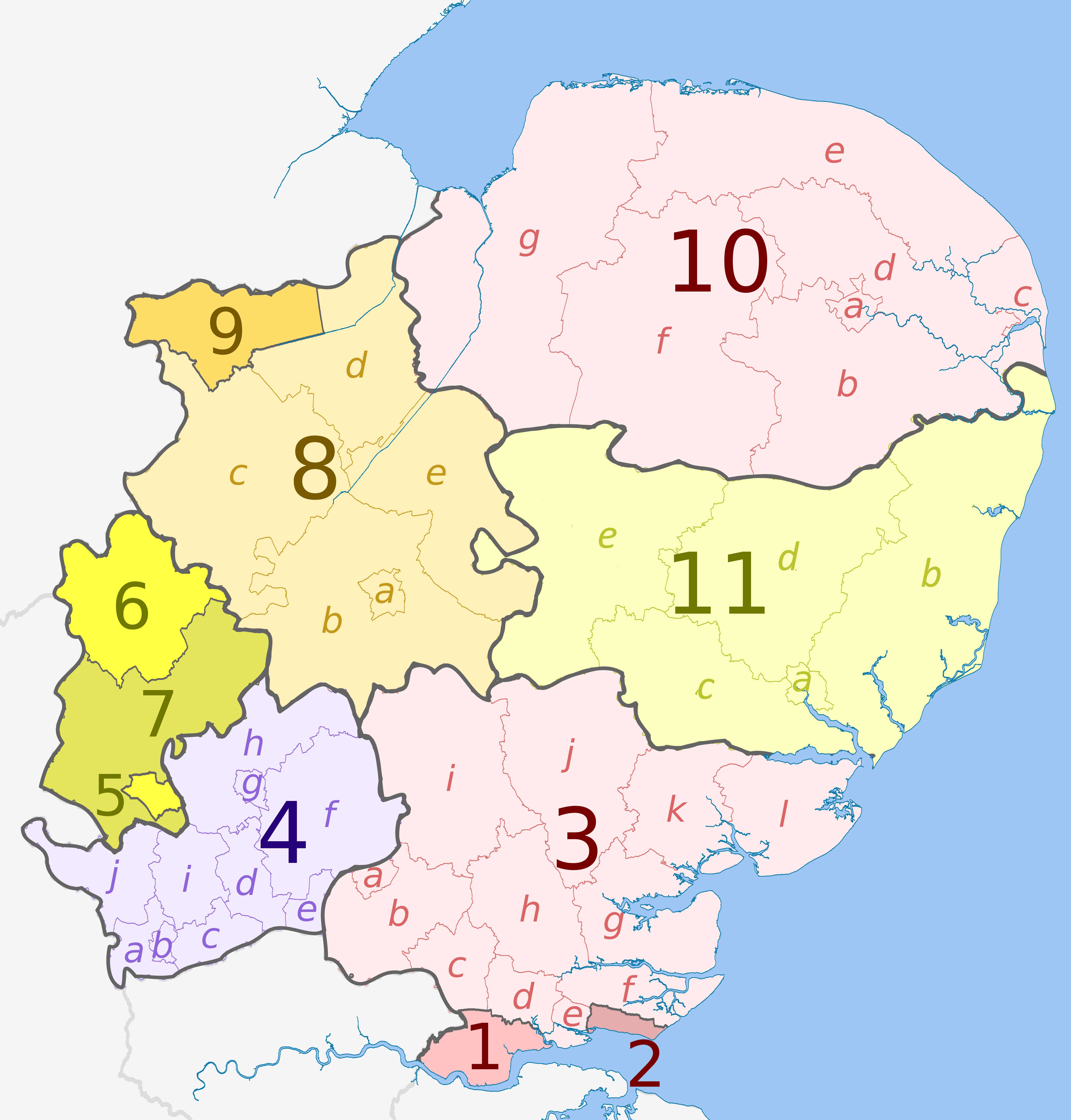
English: Map of the East of England region, showing its counties and administrative districts. The county colours are the same as those in File:English metropolitan and non-metropolitan counties 2009.svg.
Equirectangular map projection on WGS 84 datum, with N/S stretched 160% Geographic limits:
|
| วันที่ | (UTC) |
| แหล่งที่มา |
This file was derived from: |
| ผู้สร้างสรรค์ |
|


การอนุญาตใช้สิทธิ
ไฟล์นี้อยู่ภายใต้สัญญาอนุญาต ครีเอทีฟคอมมอนส์ แบบแสดงที่มา-อนุญาตแบบเดียวกัน 3.0 ต้นฉบับ
การแสดงที่มา: The Equalizer, Dr Greg and Nilfanion. Contains Ordnance Survey data © Crown copyright and database right 2010
- คุณสามารถ:
- ที่จะแบ่งปัน – ที่จะทำสำเนา แจกจ่าย และส่งงานดังกล่าวต่อไป
- ที่จะเรียบเรียงใหม่ – ที่จะดัดแปลงงานดังกล่าว
- ภายใต้เงื่อนไขต่อไปนี้:
- แสดงที่มา – คุณต้องให้เกียรติเจ้าของงานอย่างเหมาะสม โดยเพิ่มลิงก์ไปยังสัญญาอนุญาต และระบุหากมีการเปลี่ยนแปลง คุณอาจทำเช่นนี้ได้ในรูปแบบใดก็ได้ตามควร แต่ต้องไม่ใช่ในลักษณะที่แนะว่าผู้ให้อนุญาตสนับสนุนคุณหรือการใช้งานของคุณ
- อนุญาตแบบเดียวกัน – หากคุณดัดแปลง เปลี่ยนรูป หรือต่อเติมงานนี้ คุณต้องใช้สัญญาอนุญาตแบบเดียวกันหรือแบบที่เหมือนกับสัญญาอนุญาตที่ใช้กับงานนี้เท่านั้น
บันทึกการอัพโหลด
This image is a derivative work of the following images:
- File:East_Midlands_districts_2011_map.svg licensed with Cc-by-sa-3.0, GFDL
- 2011-05-01T18:55:02Z Nilfanion 1099x1305 (1687648 Bytes) == Summary == {{Information |Description=Map of the [[w:East Midlands|East Midlands]] region showing the administrative districts. Equirectangular map projection on WGS 84 datum, with N/S stretched 165% Geographic limits: *
- File:English_ceremonial_counties_2010.svg licensed with Cc-by-sa-3.0, GFDL
- 2010-11-23T16:39:55Z Nilfanion 1108x1345 (308868 Bytes) thicker lines
- 2010-11-23T16:20:19Z Nilfanion 1108x1345 (301520 Bytes) tweaks
- 2010-10-26T20:34:20Z Nilfanion 817x990 (1391832 Bytes) {{Information |Description=Map showing the [[w:ceremonial counties of England]] including the City of London, in 2010. Equirectangular map projection on WGS 84 datum, with N/S stretched 170% Geographic limits: *West: 6.75W
- File:East of England counties 2009 map.svg licensed with Cc-by-sa-4.0, GFDL
- 2019-04-06T21:30:00Z The Equalizer Updated with district merges in Suffolk
Uploaded with derivativeFX
ประวัติไฟล์
คลิกวันที่/เวลาเพื่อดูไฟล์ที่ปรากฏในขณะนั้น
| วันที่/เวลา | รูปย่อ | ขนาด | ผู้ใช้ | ความเห็น | |
|---|---|---|---|---|---|
| ปัจจุบัน | 03:50, 7 เมษายน 2562 | | 5,042 × 5,275 (873 กิโลไบต์) | The Equalizer | User created page with UploadWizard |
หน้าที่มีภาพนี้
หน้าต่อไปนี้ โยงมาที่ภาพนี้:
การใช้ไฟล์ข้ามโครงการ
วิกิอื่นต่อไปนี้ใช้ไฟล์นี้:
- การใช้บน de.wikipedia.org
- การใช้บน en.wikipedia.org
- การใช้บน hr.wikipedia.org
- การใช้บน pl.wikipedia.org
- การใช้บน pnb.wikipedia.org
- การใช้บน ur.wikipedia.org