
ไฟล์:DFW Airport Diagram.svg

ขนาดของตัวอย่าง PNG นี้ของไฟล์ SVG นี้: 378 × 548 พิกเซล ความละเอียดอื่น: 165 × 240 พิกเซล | 331 × 480 พิกเซล | 530 × 768 พิกเซล | 706 × 1,024 พิกเซล | 1,413 × 2,048 พิกเซล
ดูภาพที่มีความละเอียดสูงกว่า ((ไฟล์ SVG, 378 × 548 พิกเซล, ขนาดไฟล์: 1.55 เมกะไบต์))
| รูปภาพหรือไฟล์เสียงนี้ ต้นฉบับอยู่ที่ คอมมอนส์ รายละเอียดด้านล่าง เป็นข้อความที่แสดงผลจาก ไฟล์ต้นฉบับในคอมมอนส์
|
ความย่อ
| คำอธิบาย |
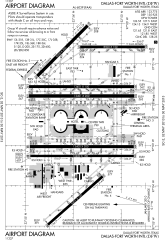
English: FAA Airport Diagram of Dallas-Fort Worth International Airport. |
| วันที่ | |
| แหล่งที่มา |
FAA Airport Diagrams; note that these change every 28 days. Taken from PDF on FAA site and converted to SVG using en:Wikipedia:How to draw SVG circuits using Xcircuit. |
| ผู้สร้างสรรค์ | Produced by the National Aeronautical Charting Office (NACO), a department of the United States en:Federal Aviation Administration. |
| ตำแหน่งที่ตั้งกล้อง | | ภาพนี้และภาพอื่น ๆ ณ สถานที่เดียวกันที่ OpenStreetMap |
|---|
W3C-validity not checked.
การอนุญาตใช้สิทธิ
This image or file is a work of a Federal Aviation Administration employee, taken or made as part of that person's official duties. As a work of the U.S. federal government, the image is in the public domain in the United States.
|
 |
ประวัติไฟล์
คลิกวันที่/เวลาเพื่อดูไฟล์ที่ปรากฏในขณะนั้น
| วันที่/เวลา | รูปย่อ | ขนาด | ผู้ใช้ | ความเห็น | |
|---|---|---|---|---|---|
| ปัจจุบัน | 21:07, 2 พฤษภาคม 2556 | | 378 × 548 (1.55 เมกะไบต์) | Grendelkhan | SVG version of FAA's PDF diagram. |
หน้าที่มีภาพนี้
หน้าต่อไปนี้ โยงมาที่ภาพนี้:
การใช้ไฟล์ข้ามโครงการ
วิกิอื่นต่อไปนี้ใช้ไฟล์นี้:
- การใช้บน ar.wikipedia.org
- การใช้บน bn.wikipedia.org
- การใช้บน de.wikipedia.org
- การใช้บน en.wikipedia.org
- การใช้บน es.wikipedia.org
- การใช้บน fa.wikipedia.org
- การใช้บน fr.wikipedia.org
- การใช้บน he.wikipedia.org
- การใช้บน id.wikipedia.org
- การใช้บน ja.wikipedia.org
- การใช้บน ru.wikipedia.org
- การใช้บน simple.wikipedia.org
- การใช้บน ta.wikipedia.org
- การใช้บน ur.wikipedia.org
- การใช้บน vi.wikipedia.org
- การใช้บน zh.wikipedia.org