
ไฟล์:Corrientes-oceanicas-en.svg

ขนาดของตัวอย่าง PNG นี้ของไฟล์ SVG นี้: 800 × 404 พิกเซล ความละเอียดอื่น: 320 × 162 พิกเซล | 640 × 323 พิกเซล | 1,024 × 517 พิกเซล | 1,280 × 647 พิกเซล | 2,560 × 1,293 พิกเซล | 976 × 493 พิกเซล
ดูภาพที่มีความละเอียดสูงกว่า ((ไฟล์ SVG, 976 × 493 พิกเซล, ขนาดไฟล์: 1.63 เมกะไบต์))
| รูปภาพหรือไฟล์เสียงนี้ ต้นฉบับอยู่ที่ คอมมอนส์ รายละเอียดด้านล่าง เป็นข้อความที่แสดงผลจาก ไฟล์ต้นฉบับในคอมมอนส์
|
ความย่อ
| คำอธิบาย |
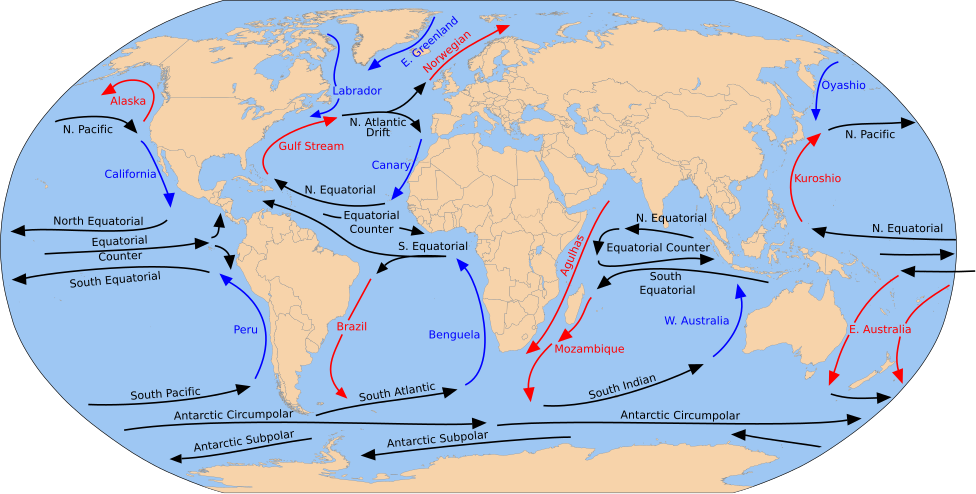
English: A detailed Robinson-projection SVG map with grouping enabled to connect all non-contiguous parts of a country's territory for easy colouring. Smaller countries can also be represented by larger circles to show their data easier. A thorough description of use and other instructions relating to can be found on the instruction page. |
| วันที่ | (UTC) |
| แหล่งที่มา |
This file was derived from: Blank map of the world (Robinson projection) (10E).svg: This file was derived from: Corrientes-oceanicas.png: |
| ผู้สร้างสรรค์ |
|
_(10E).svg)

|
ไฟล์ SVG นี้มีข้อความที่สามารถแปลได้ โดยใช้เครื่องมือแปบภาษา SVG หรือใช้ตัวแก้ไข SVG ใดก็ได้ สำหรับข้อมูลเพิ่มเติม ดูที่เกี่ยวกับการแปลไฟล์ |
ไฟล์ภาพกราฟิกส์เวกเตอร์ไม่ได้ระบุการตรวจโดย W3C นี้ สร้างขึ้นโดยใช้ Inkscape .
การอนุญาตใช้สิทธิ
ข้าพเจ้า ในฐานะผู้ถือลิขสิทธิ์ของภาพหรือสื่อนี้ อนุญาตให้ใช้ภาพหรือสื่อนี้ภายใต้เงื่อนไขต่อไปนี้
| ข้าพเจ้า ผู้ถือลิขสิทธิ์ในงานนี้ ขอมอบงานให้เป็นสาธารณสมบัติ ประกาศนี้มีผลทั่วโลก ในบางประเทศ การกระทำดังกล่าวอาจไม่สามารถทำได้ตามกฎหมาย ข้าพเจ้าอนุญาตให้ทุกคนมีสิทธิ์ในการใช้ไฟล์นี้ในทุกเหตุผลการใช้ โดยไม่มีมีเงื่อนไข เว้นแต่กฎหมายไม่อนุญาตให้ทำเช่นนั้น |
บันทึกการอัพโหลด
This image is a derivative work of the following images:
- File:Blank map of the world (Robinson projection) (10E).svg licensed with PD-self
- 2011-05-16T04:18:31Z Milenioscuro 3100x1600 (2087786 Bytes) {{Information |Description={{en|1=A detailed Robinson-projection [[Help:SVG|SVG]] map with grouping enabled to connect all non-contiguous parts of a country's territory for easy colouring. Smaller countries can also be repres
Uploaded with derivativeFX
ประวัติไฟล์
คลิกวันที่/เวลาเพื่อดูไฟล์ที่ปรากฏในขณะนั้น
| วันที่/เวลา | รูปย่อ | ขนาด | ผู้ใช้ | ความเห็น | |
|---|---|---|---|---|---|
| ปัจจุบัน | 00:43, 31 กรกฎาคม 2566 | | 976 × 493 (1.63 เมกะไบต์) | Matěj Grabovský | File uploaded using svgtranslate tool (https://svgtranslate.toolforge.org/). Added translation for cs. |
| 01:08, 16 ธันวาคม 2557 |  | 976 × 493 (1.67 เมกะไบต์) | RicHard-59 | Guls -> Gulf | |
| 21:20, 28 เมษายน 2557 |  | 976 × 493 (1.58 เมกะไบต์) | Moja~commonswiki | Correct "Oyashia" -> "Oyashio" | |
| 21:51, 17 สิงหาคม 2555 |  | 976 × 493 (1.66 เมกะไบต์) | Popadius | Reverted to version as of 14:42, 17 August 2012 | |
| 21:49, 17 สิงหาคม 2555 |  | 976 × 493 (1.1 เมกะไบต์) | Popadius | small fix | |
| 21:42, 17 สิงหาคม 2555 |  | 976 × 493 (1.66 เมกะไบต์) | Popadius | == {{int:filedesc}} == {{Information |Description={{en|1=A detailed Robinson-projection SVG map with grouping enabled to connect all non-contiguous parts of a country's territory for easy colouring. Smaller countries can also be represente... |
หน้าที่มีภาพนี้
หน้าต่อไปนี้ โยงมาที่ภาพนี้:
การใช้ไฟล์ข้ามโครงการ
วิกิอื่นต่อไปนี้ใช้ไฟล์นี้:
- การใช้บน ca.wikipedia.org
- การใช้บน cs.wikipedia.org
- การใช้บน de.wikipedia.org
- การใช้บน en.wikipedia.org
- การใช้บน eo.wikipedia.org
- การใช้บน es.wikipedia.org
- การใช้บน eu.wikipedia.org
- Ozeano Australa
- Golkoko itsaslasterra
- Humboldt itsaslasterra
- Agulhasko itsaslasterra
- Alaskako itsaslasterra
- Itsaslaster Zirkunpolar Antartikoa
- Antilletako itsaslasterra
- Benguelako itsaslasterra
- Brasilgo itsaslasterra
- Kaliforniako itsaslasterra
- Kanarietako itsaslasterra
- Floridako itsaslasterra
- Azoreetako itsaslasterra
- Karibeko itsaslasterra
- Cromwell itsaslasterra
- Ekialdeko Australiako itsaslasterra
- Groenlandiako ekialdeko itsaslasterra
- Madagaskarko ekialdeko itsaslasterra
- Malvinetako itsaslasterra
- Gineako itsaslasterra
- Irminger itsaslasterra
- Kuroshio itsaslasterra
- Oyashio itsaslasterra
- Labradorko itsaslasterra
- Leeuwingo itsaslasterra
- Lomonosov itsaslasterra
- Madagaskarko itsaslasterra
- Mindanaoko itsaslasterra
- Mozambikeko itsaslasterra
- Ipar Atlantikoko itsaslasterra
- Iparraldeko itsaslaster ekuatoriala
- Kontralaster Ekuatoriala
- Ipar Pazifikoko itsaslasterra
- Norvegiako itsaslasterra
- Portugalgo itsaslasterra
ดูการใช้ข้ามโครงการเพิ่มเติมของไฟล์นี้