
ไฟล์:Colonisation 1754.png

ดูภาพที่มีความละเอียดสูงกว่า (1,799 × 789 พิกเซล, ขนาดไฟล์: 144 กิโลไบต์, ชนิดไมม์: image/png)
| รูปภาพหรือไฟล์เสียงนี้ ต้นฉบับอยู่ที่ คอมมอนส์ รายละเอียดด้านล่าง เป็นข้อความที่แสดงผลจาก ไฟล์ต้นฉบับในคอมมอนส์
|
| คำอธิบาย |
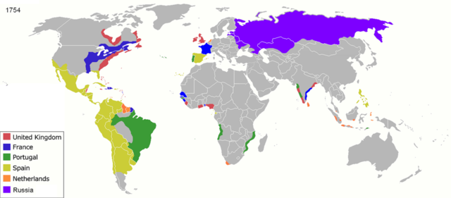
Map of major world powers by year, derived from public domain animated map on wikipedia.
As the orriginal licence of the animation was Public Domain, this image which has been derived from it is too:
|
||||||||||||||||||
| วันที่ | |||||||||||||||||||
| แหล่งที่มา | public domain animated map by ArdadN here | ||||||||||||||||||
| ผู้สร้างสรรค์ | ArdadN | ||||||||||||||||||
| เวอร์ชันอื่น |
|
||||||||||||||||||

.jpg)
._LOC_2001620596.jpg)
ประวัติไฟล์
คลิกวันที่/เวลาเพื่อดูไฟล์ที่ปรากฏในขณะนั้น
| วันที่/เวลา | รูปย่อ | ขนาด | ผู้ใช้ | ความเห็น | |
|---|---|---|---|---|---|
| ปัจจุบัน | 06:55, 18 มีนาคม 2565 | | 1,799 × 789 (144 กิโลไบต์) | M.Bitton | per https://commons.wikimedia.org/w/index.php?title=Commons:Graphic_Lab/Map_workshop&oldid=640501111#Wrong_borders |
| 19:27, 4 ตุลาคม 2563 |  | 1,799 × 789 (460 กิโลไบต์) | Ориенталист | quality | |
| 16:30, 5 เมษายน 2563 |  | 1,200 × 526 (263 กิโลไบต์) | Ориенталист | cosmetic changes | |
| 21:47, 27 มีนาคม 2563 |  | 1,799 × 789 (532 กิโลไบต์) | Ориенталист | Clarified the territory of Russia. By 1754, the north of Siberia had already been explored | |
| 03:44, 3 พฤศจิกายน 2560 |  | 1,425 × 625 (71 กิโลไบต์) | Alvin Lee | According to the Treaty of Nerchinsk in 1689, Outer Manchuria was the territory of China (Qing Dynasty), not Russia. Russia got Outer Manchuria after Treaty of Aigun of 1858. | |
| 03:30, 3 พฤศจิกายน 2560 |  | 1,425 × 625 (47 กิโลไบต์) | Alvin Lee | I am changing the ancient boarder of Qing dynasty and Russia, not the modern boarder | |
| 22:35, 14 กุมภาพันธ์ 2560 |  | 1,425 × 625 (43 กิโลไบต์) | Fentener van Vlissingen | Reverted to version as of 23:29, 27 June 2012 (UTC) that edit did not change the borders between Russia and China and re-added errors fixed in previous version | |
| 07:35, 3 สิงหาคม 2557 |  | 1,425 × 625 (47 กิโลไบต์) | Alvin Lee | Correcting the boundaries of Russia and China | |
| 06:29, 28 มิถุนายน 2555 |  | 1,425 × 625 (43 กิโลไบต์) | Fentener van Vlissingen | There are still many things wrong with this map, but I corrected the most blatant errors: right shade of Orange for Demerara, Essequibo, Berbice, added Dutch Gold Coast, Dutch Malabar, Dutch Coromandel, Dutch Bengal. European presence in Africa and Ind... | |
| 04:27, 24 มกราคม 2554 |  | 1,425 × 625 (66 กิโลไบต์) | Micsha~commonswiki | Reverted to version as of 13:52, 29 April 2010 |
หน้าที่มีภาพนี้
หน้าต่อไปนี้ โยงมาที่ภาพนี้:
การใช้ไฟล์ข้ามโครงการ
วิกิอื่นต่อไปนี้ใช้ไฟล์นี้:
- การใช้บน als.wikipedia.org
- การใช้บน ar.wikipedia.org
- การใช้บน ast.wikipedia.org
- การใช้บน azb.wikipedia.org
- การใช้บน bn.wikipedia.org
- การใช้บน br.wikipedia.org
- การใช้บน de.wikipedia.org
- การใช้บน el.wikipedia.org
- การใช้บน en.wikipedia.org
- การใช้บน es.wikipedia.org
- การใช้บน et.wikipedia.org
- การใช้บน fr.wikipedia.org
- การใช้บน ko.wikipedia.org
- การใช้บน la.wikipedia.org
- การใช้บน no.wikipedia.org
- การใช้บน oc.wikipedia.org
- การใช้บน pt.wikipedia.org
- การใช้บน ro.wikipedia.org
- การใช้บน sh.wikipedia.org
- การใช้บน sw.wikipedia.org
- การใช้บน te.wikipedia.org
- การใช้บน uk.wikipedia.org