
ไฟล์:8th century Durga temple exterior view, Aihole Hindu temples and monuments 3.jpg
ดูภาพที่มีความละเอียดสูงกว่า (3,242 × 2,056 พิกเซล, ขนาดไฟล์: 1.32 เมกะไบต์, ชนิดไมม์: image/jpeg)
| รูปภาพหรือไฟล์เสียงนี้ ต้นฉบับอยู่ที่ คอมมอนส์ รายละเอียดด้านล่าง เป็นข้อความที่แสดงผลจาก ไฟล์ต้นฉบับในคอมมอนส์
|
ความย่อ
| คำอธิบาย |
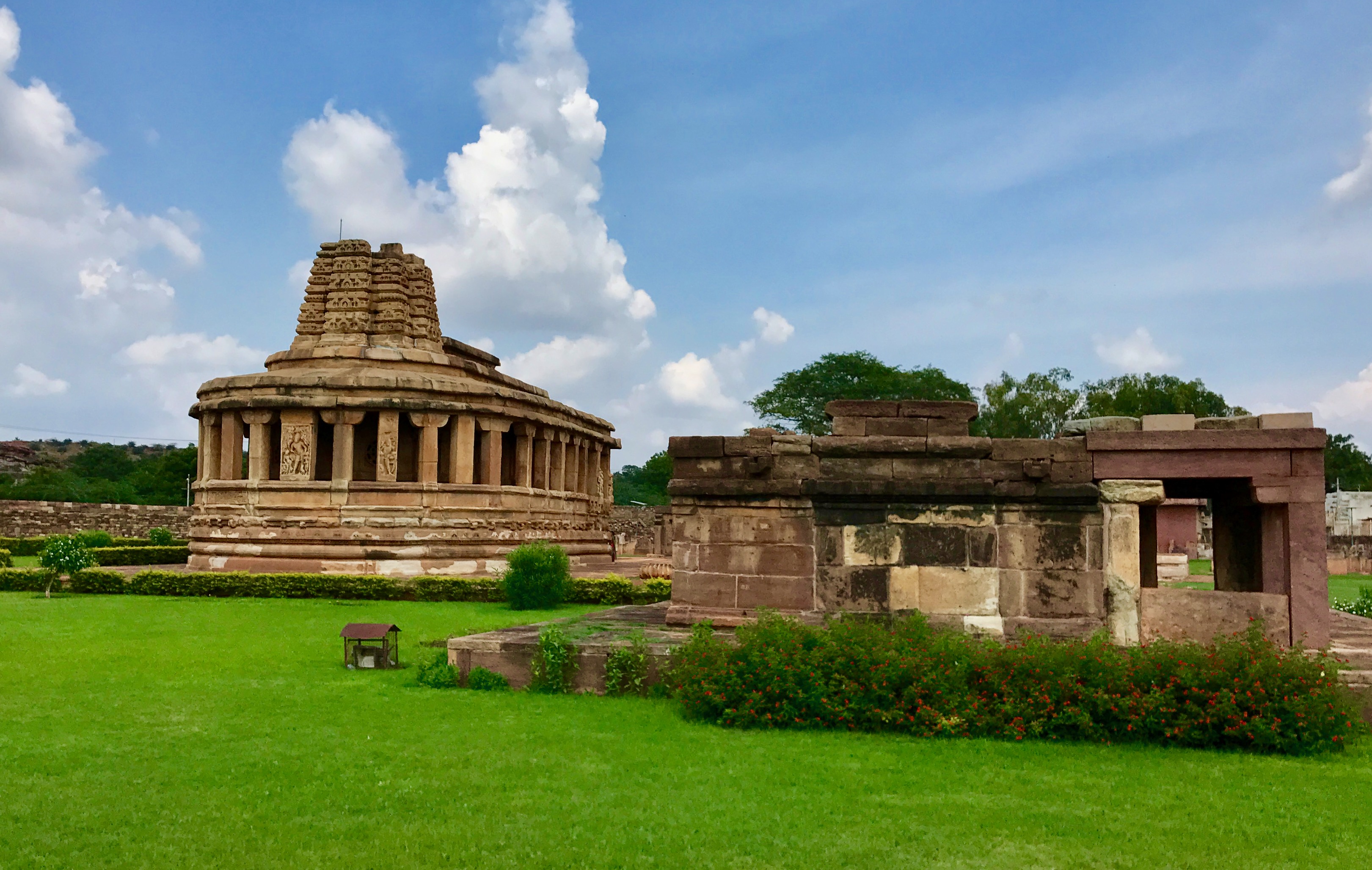
English: Aihole temples and monuments, also called Aivalli or Ayyavole or Aiholi temples and monuments, are a collection of over 100 temples built predominantly between 6th and 8th century near Malaprabha river in Karnataka. At this point, the river turns northwards towards the Himalayas which likely had significance as a location.
Though defaced and damaged after the region was conquered by Muslim commanders of the Delhi Sultanate, the collection is one of the earliest surviving temples and window to ancient Indian arts, religious beliefs, society and architecture. Almost all temples are related to Hinduism, but these co-exist with a few Jain temples of this period and one Buddhist monument. Both north Indian and south Indian styles fuse here, with monuments suggesting experimentation of ideas and building styles under the sponsorship of late Gupta period Hindu kingdoms, particularly the Calukyas and Rashtrakutas. The Durga temple is actually a Surya temple, named as Durga because its ceiling was fortified later with stones and served as a "Durg" or watch / viewpoint. The temple is a rich collection of life size Hindu statues of Vaishnavism, Shaivism and Shaktism traditions. The carvings also show Kama and Artha scenes of Indian society from the 2nd half of the 1st millennium CE, while some panels display scenes from the Hindu epic Ramayana. |
| วันที่ | |
| แหล่งที่มา | งานของตัว |
| ผู้สร้างสรรค์ | Ms Sarah Welch |
| ตำแหน่งที่ตั้งกล้อง | | ภาพนี้และภาพอื่น ๆ ณ สถานที่เดียวกันที่ OpenStreetMap |
|---|
การอนุญาตใช้สิทธิ
- คุณสามารถ:
- ที่จะแบ่งปัน – ที่จะทำสำเนา แจกจ่าย และส่งงานดังกล่าวต่อไป
- ที่จะเรียบเรียงใหม่ – ที่จะดัดแปลงงานดังกล่าว
- ภายใต้เงื่อนไขต่อไปนี้:
- แสดงที่มา – คุณต้องให้เกียรติเจ้าของงานอย่างเหมาะสม โดยเพิ่มลิงก์ไปยังสัญญาอนุญาต และระบุหากมีการเปลี่ยนแปลง คุณอาจทำเช่นนี้ได้ในรูปแบบใดก็ได้ตามควร แต่ต้องไม่ใช่ในลักษณะที่แนะว่าผู้ให้อนุญาตสนับสนุนคุณหรือการใช้งานของคุณ
- อนุญาตแบบเดียวกัน – หากคุณดัดแปลง เปลี่ยนรูป หรือต่อเติมงานนี้ คุณต้องใช้สัญญาอนุญาตแบบเดียวกันหรือแบบที่เหมือนกับสัญญาอนุญาตที่ใช้กับงานนี้เท่านั้น
ประวัติไฟล์
คลิกวันที่/เวลาเพื่อดูไฟล์ที่ปรากฏในขณะนั้น
| วันที่/เวลา | รูปย่อ | ขนาด | ผู้ใช้ | ความเห็น | |
|---|---|---|---|---|---|
| ปัจจุบัน | 05:10, 28 กันยายน 2560 | | 3,242 × 2,056 (1.32 เมกะไบต์) | Ms Sarah Welch | User created page with UploadWizard |
หน้าที่มีภาพนี้
หน้าต่อไปนี้ โยงมาที่ภาพนี้:
การใช้ไฟล์ข้ามโครงการ
วิกิอื่นต่อไปนี้ใช้ไฟล์นี้: