
ไฟล์:2011 Tohoku earthquake observed tsunami heights en.png
ขนาดของตัวอย่างนี้: 656 × 600 พิกเซล ความละเอียดอื่น: 263 × 240 พิกเซล | 525 × 480 พิกเซล | 700 × 640 พิกเซล
ดูภาพที่มีความละเอียดสูงกว่า (700 × 640 พิกเซล, ขนาดไฟล์: 298 กิโลไบต์, ชนิดไมม์: image/png)
| รูปภาพหรือไฟล์เสียงนี้ ต้นฉบับอยู่ที่ คอมมอนส์ รายละเอียดด้านล่าง เป็นข้อความที่แสดงผลจาก ไฟล์ต้นฉบับในคอมมอนส์
|
| คำอธิบาย |
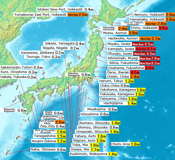
English: Map of 2011 Tohoku(Sendai) earthquake observed tsunami heights in Japan.
日本語: 東北地方太平洋沖地震で観測された、日本各地の津波の高さ(英語版)。 |
||||||
| วันที่ | |||||||
| แหล่งที่มา |
This file was derived from: 2011 Tohoku earthquake observed tsunami heights.png |
||||||
| ผู้สร้างสรรค์ | Original by Pekachu, translated by Eastwind41 | ||||||
| การอนุญาต (การใช้ไฟล์นี้ใหม่) |
|
||||||
| เวอร์ชันอื่น |
SVG re-designed version available |
| ภาพนี้ ได้รับการปรับแต่งภาพ ซึ่งหมายความว่าจะได้รับการเปลี่ยนแปลงภาพต่างจากต้นฉบับ การปรับปรุง: Place name translating to English language(地名の英訳).
|
ประวัติไฟล์
คลิกวันที่/เวลาเพื่อดูไฟล์ที่ปรากฏในขณะนั้น
| วันที่/เวลา | รูปย่อ | ขนาด | ผู้ใช้ | ความเห็น | |
|---|---|---|---|---|---|
| ปัจจุบัน | 20:43, 14 พฤษภาคม 2554 | | 700 × 640 (298 กิโลไบต์) | Eastwind41 | {{Information |Description ={{en|1=Map of 2011 Tohoku(Sendai) earthquake observed tsunami heights in Japan.}} {{ja|1=東北地方太平洋沖地震で観測された、日本各地の津波の高さ(英語版)。}} |Source ={{Derived from|2011 |
หน้าที่มีภาพนี้
หน้าต่อไปนี้ โยงมาที่ภาพนี้:
การใช้ไฟล์ข้ามโครงการ
วิกิอื่นต่อไปนี้ใช้ไฟล์นี้:
- การใช้บน en.wikipedia.org
- การใช้บน mk.wikipedia.org
- การใช้บน ms.wikipedia.org
- การใช้บน ro.wikinews.org