
ไฟล์:14-W 2000 track.png

ขนาดของตัวอย่างนี้: 800 × 495 พิกเซล ความละเอียดอื่น: 320 × 198 พิกเซล | 640 × 396 พิกเซล | 1,024 × 633 พิกเซล | 1,280 × 791 พิกเซล | 2,700 × 1,669 พิกเซล
ดูภาพที่มีความละเอียดสูงกว่า (2,700 × 1,669 พิกเซล, ขนาดไฟล์: 682 กิโลไบต์, ชนิดไมม์: image/png)
| รูปภาพหรือไฟล์เสียงนี้ ต้นฉบับอยู่ที่ คอมมอนส์ รายละเอียดด้านล่าง เป็นข้อความที่แสดงผลจาก ไฟล์ต้นฉบับในคอมมอนส์
|
ความย่อ
| คำอธิบาย |
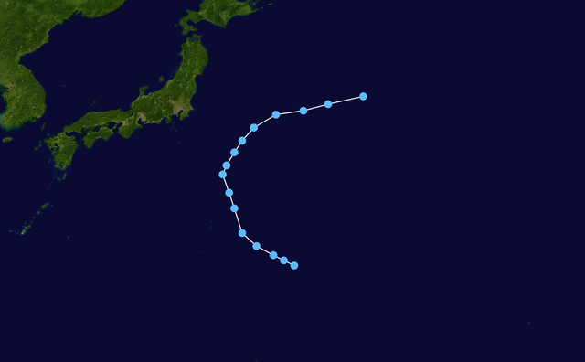
English: Track map of Tropical Depression 14W of the 2000 Pacific typhoon season. The points show the location of the storm at 6-hour intervals. The colour represents the storm's maximum sustained wind speeds as classified in the (see below), and the shape of the data points represent the nature of the storm, according to the legend below. Tropical depression (≤38 mph, ≤62 km/h)
Tropical storm (39–73 mph, 63–118 km/h)
Category 1 (74–95 mph, 119–153 km/h)
Category 2 (96–110 mph, 154–177 km/h)
Category 3 (111–129 mph, 178–208 km/h)
Category 4 (130–156 mph, 209–251 km/h)
Category 5 (≥157 mph, ≥252 km/h)
Unknown
Storm type |
| วันที่ | 2000-08-06–2000-08-10 |
| แหล่งที่มา | Created by Nilfanion using Wikipedia:WikiProject Tropical cyclones/Tracks. The background image is from NASA. Tracking data is from the Joint Typhoon Warning Center[1]. |
| ผู้สร้างสรรค์ | Nilfanion |
การอนุญาตใช้สิทธิ
| งานนี้ได้ถูกเผยแพร่สู่สาธารณสมบัติโดยเจ้าของ Nilfanion ซึ่งมีผลทั่วโลก ในบางประเทศ การกระทำดังกล่าวอาจไม่สามารถทำได้ตามกฎหมาย Nilfanion อนุญาตให้ทุกคนมีสิทธิ์ในการใช้ไฟล์นี้ในทุกเหตุผลการใช้ โดยไม่มีมีเงื่อนไข เว้นแต่กฎหมายไม่อนุญาตให้ทำเช่นนั้น |
ประวัติไฟล์
คลิกวันที่/เวลาเพื่อดูไฟล์ที่ปรากฏในขณะนั้น
| วันที่/เวลา | รูปย่อ | ขนาด | ผู้ใช้ | ความเห็น | |
|---|---|---|---|---|---|
| ปัจจุบัน | 12:31, 7 กุมภาพันธ์ 2565 | | 2,700 × 1,669 (682 กิโลไบต์) | Supportstorm | JTWC BT data |
| 13:20, 23 กุมภาพันธ์ 2563 |  | 2,700 × 1,669 (482 กิโลไบต์) | Nino Marakot | Corrections | |
| 06:01, 11 ธันวาคม 2557 |  | 2,700 × 1,669 (681 กิโลไบต์) | Supportstorm | Corrected points | |
| 08:38, 7 มกราคม 2550 |  | 1,024 × 633 (124 กิโลไบต์) | NilfaBot | {{Information |Description={{hurricane auto track map|type=Tropical Depression|name={{subst:PAGENAME}}|source]JTWC}} |Source= |Date= |Author= |Permission= |other_versions= }} |
หน้าที่มีภาพนี้
หน้าต่อไปนี้ โยงมาที่ภาพนี้:
การใช้ไฟล์ข้ามโครงการ
วิกิอื่นต่อไปนี้ใช้ไฟล์นี้:
- การใช้บน en.wikipedia.org
- การใช้บน vi.wikipedia.org
- การใช้บน zh.wikipedia.org