
ไฟล์:Tornado Alley.svg

ขนาดของตัวอย่าง PNG นี้ของไฟล์ SVG นี้: 765 × 600 พิกเซล ความละเอียดอื่น: 306 × 240 พิกเซล | 612 × 480 พิกเซล | 980 × 768 พิกเซล | 1,280 × 1,004 พิกเซล | 2,560 × 2,007 พิกเซล | 820 × 643 พิกเซล
ดูภาพที่มีความละเอียดสูงกว่า ((ไฟล์ SVG, 820 × 643 พิกเซล, ขนาดไฟล์: 1.26 เมกะไบต์))
| รูปภาพหรือไฟล์เสียงนี้ ต้นฉบับอยู่ที่ คอมมอนส์ รายละเอียดด้านล่าง เป็นข้อความที่แสดงผลจาก ไฟล์ต้นฉบับในคอมมอนส์
|
ความย่อ
| คำอธิบาย |
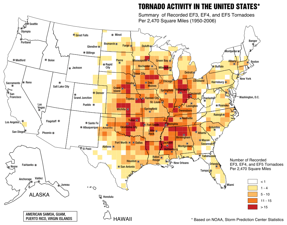
English: A map of the frequency of F3 and greater intensity tornadoes by area. The darker colors highlight the areas typically known as a Tornado Alley. |
| วันที่ | |
| แหล่งที่มา | Image from Federal Emergency Management Agency, a United States government agency, booklet FEMA 320 Third Edition, Section 1, Figure 1.1, page 3, titled Taking Shelter from the Storm: Building a Safe Room Inside your House |
| ผู้สร้างสรรค์ | FEMA personnel |
การอนุญาตใช้สิทธิ
This image is a work of a Federal Emergency Management Agency employee, taken or made as part of that person's official duties. As works of the U.S. federal government, all FEMA images are in the public domain in the United States. Additional media usage information may be found at https://www.fema.gov/photo-video-audio-use-guidelines
|
ประวัติไฟล์
คลิกวันที่/เวลาเพื่อดูไฟล์ที่ปรากฏในขณะนั้น
| วันที่/เวลา | รูปย่อ | ขนาด | ผู้ใช้ | ความเห็น | |
|---|---|---|---|---|---|
| ปัจจุบัน | 06:31, 21 พฤษภาคม 2560 | | 820 × 643 (1.26 เมกะไบต์) | Qwewqa | Rotate and add margins |
| 06:03, 21 พฤษภาคม 2560 |  | 651 × 801 (1.24 เมกะไบต์) | Qwewqa | Fix background | |
| 05:56, 21 พฤษภาคม 2560 |  | 651 × 801 (1.28 เมกะไบต์) | Qwewqa | User created page with UploadWizard |
หน้าที่มีภาพนี้
หน้าต่อไปนี้ โยงมาที่ภาพนี้:
การใช้ไฟล์ข้ามโครงการ
วิกิอื่นต่อไปนี้ใช้ไฟล์นี้:
- การใช้บน bg.wikipedia.org
- การใช้บน br.wikipedia.org
- การใช้บน el.wikipedia.org
- การใช้บน en.wikipedia.org
- การใช้บน he.wikipedia.org
- การใช้บน zh.wikipedia.org