
ไฟล์:The longest pontoon bridge in the world, spanning Russellville and Dardanelle, Arkansas. - NARA - 516537.tif
ดูภาพที่มีความละเอียดสูงกว่า (3,000 × 2,153 พิกเซล, ขนาดไฟล์: 6.16 เมกะไบต์, ชนิดไมม์: image/tiff)
| รูปภาพหรือไฟล์เสียงนี้ ต้นฉบับอยู่ที่ คอมมอนส์ รายละเอียดด้านล่าง เป็นข้อความที่แสดงผลจาก ไฟล์ต้นฉบับในคอมมอนส์
|
ความย่อ
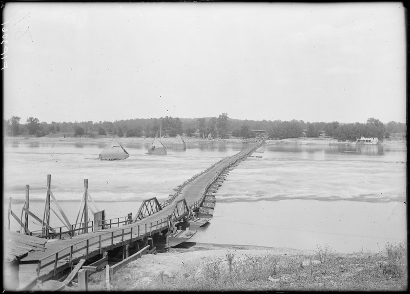
| The longest pontoon bridge in the world, spanning Russellville and Dardanelle, Arkansas.
( |
|||||||||||||||||||||||||||
|---|---|---|---|---|---|---|---|---|---|---|---|---|---|---|---|---|---|---|---|---|---|---|---|---|---|---|---|
| ผู้สร้างสรรค์ |
Unknown author หรือ not provided translate |
||||||||||||||||||||||||||
| Record creator | Department of Agriculture. Bureau of Plant Industry. Office of Horticultural and Pomological Investigation. (ca. 1913 - 1926) | ||||||||||||||||||||||||||
| ชื่อเรื่อง |
The longest pontoon bridge in the world, spanning Russellville and Dardanelle, Arkansas. |
||||||||||||||||||||||||||
| วันที่ | 2442 หรือ 2443 - 2460 หรือ 2461 | ||||||||||||||||||||||||||
| Collection |
|
||||||||||||||||||||||||||
| Record ID |
|
||||||||||||||||||||||||||
| แหล่งที่มา | U.S. National Archives and Records Administration | ||||||||||||||||||||||||||
| เวอร์ชันอื่น |
Please do not overwrite this file: any cropping or other restoration work should be uploaded with a new name and linked in this page's "other versions=" parameter, so that this file represents the exact file found in the NARA catalog record to which it links. The metadata on this page was imported directly from NARA's catalog record; additional descriptive text may be added by Wikimedians to the template below with the "description=" parameter, but please do not modify the other fields. translate
|
||||||||||||||||||||||||||


การอนุญาตใช้สิทธิ
This file was provided to Wikimedia Commons by the National Archives and Records Administration as part of a cooperation project. The National Archives and Records Administration provides images depicting American and global history which are public domain or licensed under a free license.
|
งานนี้เป็น สาธารณสมบัติ ในประเทศสหรัฐอเมริกา เนื่องจากเป็นงานของรัฐบาลกลางสหรัฐอเมริกา ทั้งนี้ ตามความของมาตรา 105 หมวด 1 ลักษณะ 17 แห่งประมวลกฎหมายสหรัฐอเมริกา ดูเพิ่มที่ ลิขสิทธิ์
หมายเหตุ ข้อความข้างต้นใช้บังคับแก่งานของรัฐบาลกลางสหรัฐอเมริกาเท่านั้น งานของรัฐใด ๆ ในสหรัฐอเมริกา ดินแดน เครือจักรภพ เทศมณฑล เทศบาล หรือองค์กรปกครองส่วนท้องถิ่นอื่นใด ไม่ถึอเป็นงานที่เป็นสาธารณสมบัติตามประมวลกฎหมายนี้ นอกจากนี้ แม่แบบนี้ไม่ใช้กับตราไปรษณียากรแบบใด ๆ ที่กรมไปรษณีย์แห่งสหรัฐอเมริกา นำออกใช้ตั้งแต่ ค.ศ. 1978 (พ.ศ. 2521) เป็นต้นมา ซึ่งมีลิขสิทธิ์และไม่เป็นสาธารณสมบัติ (ดูรายละเอียดที่ ระเบียบแห่งสำนักงานลิขสิทธิ์ บทย่อที่ 2 ข้อ 206.02 (b))
|
 | |
| ไฟล์นี้ได้ถูกระบุว่าไม่มีข้อจำกัดภายใต้กฎหมายลิขสิทธิ์ รวมถึงสิทธิที่เกี่ยวข้องและที่ใกล้เคียงกัน | ||
ประวัติไฟล์
คลิกวันที่/เวลาเพื่อดูไฟล์ที่ปรากฏในขณะนั้น
| วันที่/เวลา | รูปย่อ | ขนาด | ผู้ใช้ | ความเห็น | |
|---|---|---|---|---|---|
| ปัจจุบัน | 16:30, 2 ตุลาคม 2554 |  | 3,000 × 2,153 (6.16 เมกะไบต์) | US National Archives bot | == {{int:filedesc}} == {{NARA-image-full |Title=The longest pontoon bridge in the world, spanning Russellville and Dardanelle, Arkansas. |Scope and content= |General notes= |ARC=516537 |Local identifier=54-HPN-3061 |Creator=Department of Agriculture. Bur |
หน้าที่มีภาพนี้
หน้าต่อไปนี้ โยงมาที่ภาพนี้:
การใช้ไฟล์ข้ามโครงการ
วิกิอื่นต่อไปนี้ใช้ไฟล์นี้:
- การใช้บน af.wikipedia.org
- การใช้บน en.wikipedia.org