
ไฟล์:Tectonic plates boundaries World map Wt 180degE centered-en.svg

ขนาดของตัวอย่าง PNG นี้ของไฟล์ SVG นี้: 800 × 489 พิกเซล ความละเอียดอื่น: 320 × 196 พิกเซล | 640 × 391 พิกเซล | 1,024 × 626 พิกเซล | 1,280 × 782 พิกเซล | 2,560 × 1,564 พิกเซล | 4,903 × 2,996 พิกเซล
ดูภาพที่มีความละเอียดสูงกว่า ((ไฟล์ SVG, 4,903 × 2,996 พิกเซล, ขนาดไฟล์: 4.86 เมกะไบต์))
| รูปภาพหรือไฟล์เสียงนี้ ต้นฉบับอยู่ที่ คอมมอนส์ รายละเอียดด้านล่าง เป็นข้อความที่แสดงผลจาก ไฟล์ต้นฉบับในคอมมอนส์
|
ความย่อ
| คำอธิบาย |
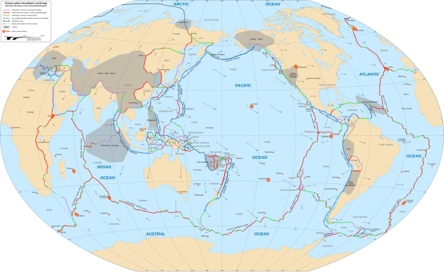
English: World map in English showing the tectonic plates boundaries with their movement vectors and selected hotspots.
Français : Carte mondiale en anglais des limites des plaques tectoniques avec leurs vecteurs de déplacement et une sélection de hotspots.
Español: Mapa en inglés que muestra las placas tectónicas con sus vectores de movimiento.
Winkel tripel projection; central longitude: 180° E |
||
| วันที่ | |||
| แหล่งที่มา |
|
||
| ผู้สร้างสรรค์ | Eric Gaba (Sting - fr:Sting) | ||
| การอนุญาต (การใช้ไฟล์นี้ใหม่) |
|
||
| เวอร์ชันอื่น |
[]
|


|
ไฟล์ SVG นี้มีข้อความที่สามารถแปลได้ โดยใช้เครื่องมือแปบภาษา SVG หรือใช้ตัวแก้ไข SVG ใดก็ได้ สำหรับข้อมูลเพิ่มเติม ดูที่เกี่ยวกับการแปลไฟล์ |
การอนุญาตใช้สิทธิ
ไฟล์นี้อยู่ภายใต้สัญญาอนุญาต ครีเอทีฟคอมมอนส์ แบบแสดงที่มา-อนุญาตแบบเดียวกัน 3.0 ต้นฉบับ
การแสดงที่มา: "Eric Gaba for Wikimedia Commons"
- คุณสามารถ:
- ที่จะแบ่งปัน – ที่จะทำสำเนา แจกจ่าย และส่งงานดังกล่าวต่อไป
- ที่จะเรียบเรียงใหม่ – ที่จะดัดแปลงงานดังกล่าว
- ภายใต้เงื่อนไขต่อไปนี้:
- แสดงที่มา – คุณต้องให้เกียรติเจ้าของงานอย่างเหมาะสม โดยเพิ่มลิงก์ไปยังสัญญาอนุญาต และระบุหากมีการเปลี่ยนแปลง คุณอาจทำเช่นนี้ได้ในรูปแบบใดก็ได้ตามควร แต่ต้องไม่ใช่ในลักษณะที่แนะว่าผู้ให้อนุญาตสนับสนุนคุณหรือการใช้งานของคุณ
- อนุญาตแบบเดียวกัน – หากคุณดัดแปลง เปลี่ยนรูป หรือต่อเติมงานนี้ คุณต้องใช้สัญญาอนุญาตแบบเดียวกันหรือแบบที่เหมือนกับสัญญาอนุญาตที่ใช้กับงานนี้เท่านั้น
ประวัติไฟล์
คลิกวันที่/เวลาเพื่อดูไฟล์ที่ปรากฏในขณะนั้น
| วันที่/เวลา | รูปย่อ | ขนาด | ผู้ใช้ | ความเห็น | |
|---|---|---|---|---|---|
| ปัจจุบัน | 03:38, 17 กุมภาพันธ์ 2561 | | 4,903 × 2,996 (4.86 เมกะไบต์) | Sting | {{Information |Description={{en|World map in English showing the tectonic plates boundaries with their movement vectors and selected hotspots.}} {{fr|Carte mondiale en anglais des limites des plaques tectoniques avec leurs vecteurs de déplacement et u... |
หน้าที่มีภาพนี้
หน้าต่อไปนี้ โยงมาที่ภาพนี้:
การใช้ไฟล์ข้ามโครงการ
วิกิอื่นต่อไปนี้ใช้ไฟล์นี้:
- การใช้บน bn.wikipedia.org
- การใช้บน el.wikipedia.org
- การใช้บน en.wikipedia.org
- Plate tectonics
- Mid-Atlantic Ridge
- Subduction
- Galápagos Islands
- Gakkel Ridge
- Pacific-Antarctic Ridge
- Eurasian Plate
- North American Plate
- Juan de Fuca Plate
- List of tectonic plates
- Farallon Plate
- South American Plate
- Gorda Plate
- Nazca Plate
- Antarctic Plate
- Pacific Plate
- Cocos Plate
- Philippine Sea Plate
- African Plate
- Arabian Plate
- Indo-Australian Plate
- Explorer Plate
- Anatolian Sub-Plate
- Australian Plate
- Abyssal plain
- Hotspot (geology)
- Mountain formation
- East Pacific Rise
- Burma Plate
- Indian Plate
- Scotia Plate
- Caribbean Plate
- Okhotsk microplate
- Amurian microplate
- Kerguelen Plateau
ดูการใช้ข้ามโครงการเพิ่มเติมของไฟล์นี้