
ไฟล์:Tabula hungariae.jpg

ขนาดของตัวอย่างนี้: 421 × 600 พิกเซล ความละเอียดอื่น: 168 × 240 พิกเซล | 337 × 480 พิกเซล | 539 × 768 พิกเซล | 719 × 1,024 พิกเซล | 1,438 × 2,048 พิกเซล | 3,236 × 4,609 พิกเซล
ดูภาพที่มีความละเอียดสูงกว่า (3,236 × 4,609 พิกเซล, ขนาดไฟล์: 3.27 เมกะไบต์, ชนิดไมม์: image/jpeg)
| รูปภาพหรือไฟล์เสียงนี้ ต้นฉบับอยู่ที่ คอมมอนส์ รายละเอียดด้านล่าง เป็นข้อความที่แสดงผลจาก ไฟล์ต้นฉบับในคอมมอนส์
|
ความย่อ
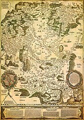
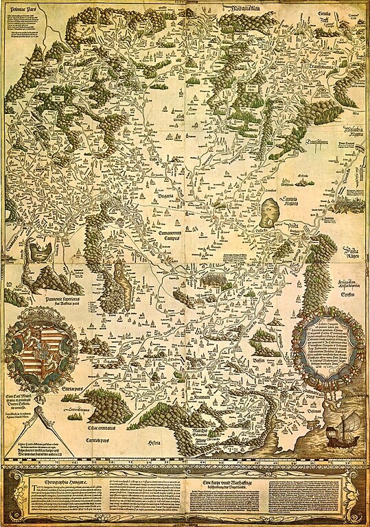
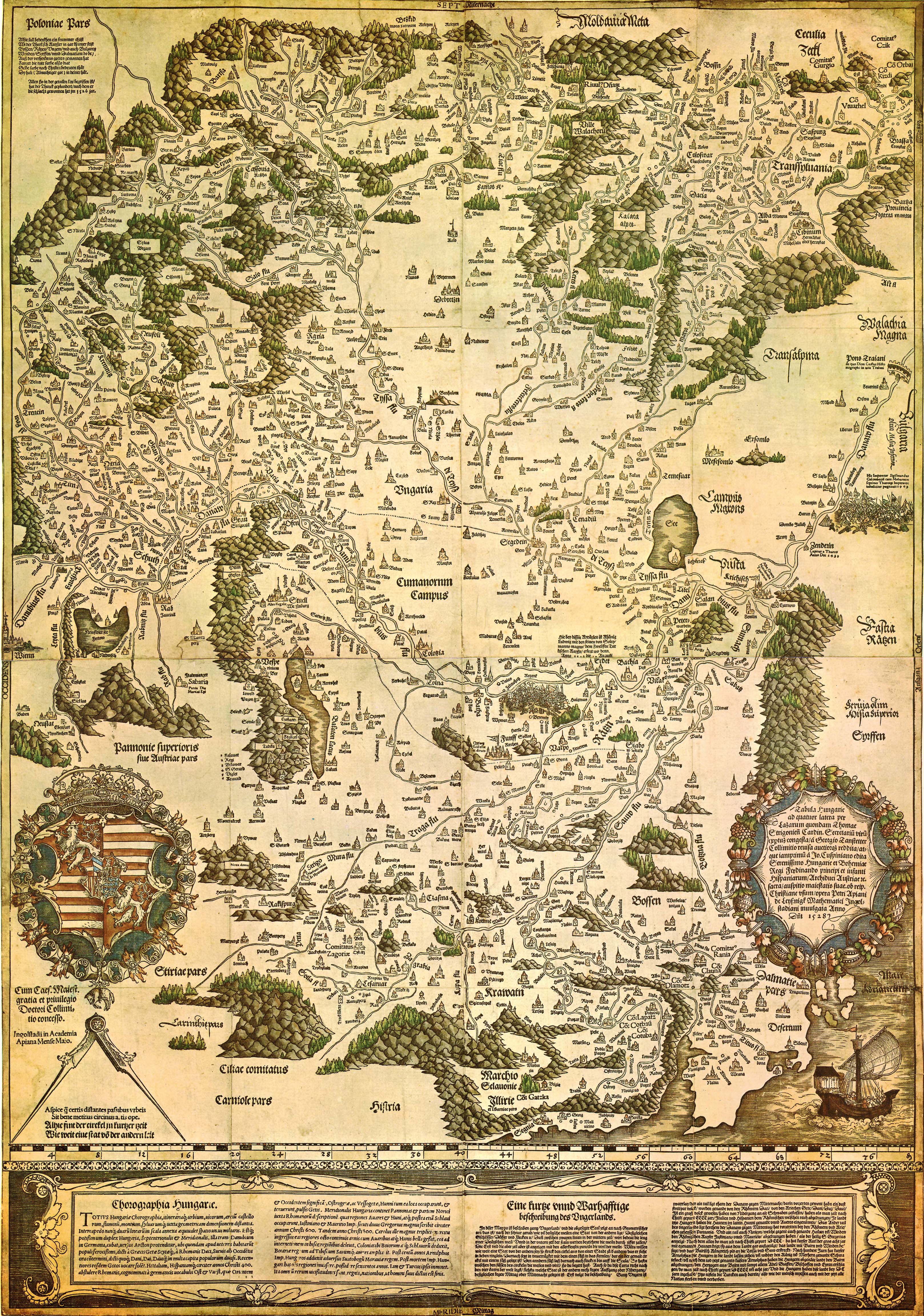
| Tabula Hungariae
|
|||||||||||||||||||||
|---|---|---|---|---|---|---|---|---|---|---|---|---|---|---|---|---|---|---|---|---|---|
| ผู้สร้างสรรค์ |
Lázár deák (Lazarus secretarius) |
 | |||||||||||||||||||
| ชื่อเรื่อง |
ละติน: Tabula Hungarie ad quatuor latera Tabula Hungariae |
||||||||||||||||||||
| โรงพิมพ์ | |||||||||||||||||||||
| Object type |
antique map |
||||||||||||||||||||
| คำอธิบาย |
Magyar: A Tabula Hungariae vagy Lázár térképe Magyarország első nyomtatott térképe, amelyet a feltehetően a magyar Lázár deák készített Српски / srpski: Lazarusova karta Ugarske iz 1528. godine na kojoj je na mestu današnjeg Novog Sada ubeleženo naselje Bistritz (Bistrica) |
||||||||||||||||||||
| วันที่ | 2068 หรือ 2069 - 2070 หรือ 2071 | ||||||||||||||||||||
| เผยแพร่ครั้งแรก |
2070 หรือ 2071 |
||||||||||||||||||||
| การเก็บรวบรวม |
|
||||||||||||||||||||
| แหล่งอ้างอิง | |||||||||||||||||||||
| งานควบคุมรายการหลักฐาน | |||||||||||||||||||||
| ที่มา/ผู้ถ่ายภาพ | http://lazarus.elte.hu/hun/maps/lazar150.jpg | ||||||||||||||||||||
| เวอร์ชันอื่น |
|
||||||||||||||||||||


การอนุญาตใช้สิทธิ
|
งานนี้เป็นสาธารณสมบัติ ในประเทศต้นกำเนิดและประเทศอื่น ๆ ที่ระยะเวลาการคุ้มครองลิขสิทธิ์น้อยกว่า 100 ปีหลังจากผู้สร้างสรรค์งานเสียชีวิต. งานนี้เป็นสาธารณสมบัติในสหรัฐอเมริกา เนื่องจากได้รับการเผยแพร่ (หรือขึ้นจดทะเบียนต่อสำนักงานลิขสิทธิ์แห่งสหรัฐ) ก่อนวันที่ 1 มกราคม ค.ศ. 1929 | |
| ไฟล์นี้ได้ถูกระบุว่าไม่มีข้อจำกัดภายใต้กฎหมายลิขสิทธิ์ รวมถึงสิทธิที่เกี่ยวข้องและที่ใกล้เคียงกัน | |
ประวัติไฟล์
คลิกวันที่/เวลาเพื่อดูไฟล์ที่ปรากฏในขณะนั้น
| วันที่/เวลา | รูปย่อ | ขนาด | ผู้ใช้ | ความเห็น | |
|---|---|---|---|---|---|
| ปัจจุบัน | 06:02, 30 สิงหาคม 2552 | | 3,236 × 4,609 (3.27 เมกะไบต์) | Qorilla | {{Information |Description={{en|1=Tabula Hungariae, first printed map of Hungary}} |Source=Hungarian Wikipedia |Author=Lázár deák (Lazarus secretarius) |Date=somewhere between 1526-1528 |Permission= |other_versions= }} Category:Old maps of Hungary |
หน้าที่มีภาพนี้
หน้าต่อไปนี้ โยงมาที่ภาพนี้:
การใช้ไฟล์ข้ามโครงการ
วิกิอื่นต่อไปนี้ใช้ไฟล์นี้:
- การใช้บน ar.wikipedia.org
- การใช้บน bn.wikipedia.org
- การใช้บน bs.wikipedia.org
- การใช้บน ca.wikipedia.org
- การใช้บน de.wikipedia.org
- การใช้บน el.wikipedia.org
- การใช้บน en.wikipedia.org
- Pannonia
- Treaty of Trianon
- Hungarian Revolution of 1956
- Austro-Hungarian Compromise of 1867
- Military Frontier
- Hungarian nobility
- History of Hungary before the Hungarian conquest
- Hungarian prehistory
- Kingdom of Hungary (1526–1867)
- History of geography
- Georg Tannstetter
- Upper Hungary
- History of the Jews in Hungary
- Music history of Hungary
- Bistrica, Novi Sad
- Lands of the Crown of Saint Stephen
- History of Transylvania
- Template:History of Hungary
- Hungarian People's Republic
- Principality of Transylvania (1570–1711)
- Military history of Hungary
- First Hungarian Republic
- Ottoman Hungary
- Hungary between the World Wars
- Principality of Hungary
- Hungarian Revolution of 1848
- Rákóczi's War of Independence
- Eastern Hungarian Kingdom
- Kingdom of Hungary (1920–1946)
- Hungary in World War I
- Second Hungarian Republic
ดูการใช้ข้ามโครงการเพิ่มเติมของไฟล์นี้