
ไฟล์:Nam-Viet 200bc.jpg
ขนาดของตัวอย่างนี้: 728 × 599 พิกเซล ความละเอียดอื่น: 292 × 240 พิกเซล | 583 × 480 พิกเซล | 933 × 768 พิกเซล | 1,166 × 960 พิกเซล
ดูภาพที่มีความละเอียดสูงกว่า (1,166 × 960 พิกเซล, ขนาดไฟล์: 856 กิโลไบต์, ชนิดไมม์: image/jpeg)
| รูปภาพหรือไฟล์เสียงนี้ ต้นฉบับอยู่ที่ คอมมอนส์ รายละเอียดด้านล่าง เป็นข้อความที่แสดงผลจาก ไฟล์ต้นฉบับในคอมมอนส์
|

|
ภาพแผนที่ทางประวัติศาสตร์นี้ ควรจะถูกสร้างใหม่เป็นกราฟิกส์เวกเตอร์ ซึ่งมีข้อดีอีกหลายประการ ดูเพิ่มเติมที่คอมมอนส์:สื่อต้องการเก็บกวาดสำหรับสารสนเทศเพิ่มเติม หากภาพนี้มีในรูปแบบกราฟิกส์เวกเตอร์อยู่แล้ว กรุณาอัปโหลดและแทนที่แม่แบบนี้ด้วย
{{vector version available|ชื่อภาพใหม่}}
แนะนำเป็นอย่างยิ่งให้ตั้งชื่อไฟล์เวกเตอร์ใหม่นั้นในรูปแบบ "Nam-Viet 200bc.svg" แล้วใส่แม่แบบ Vector version available (หรือ Vva) ซึ่งไม่ต้องใช้พารามิเตอร์ ชื่อภาพใหม่ |


ความย่อ
| คำอธิบาย |
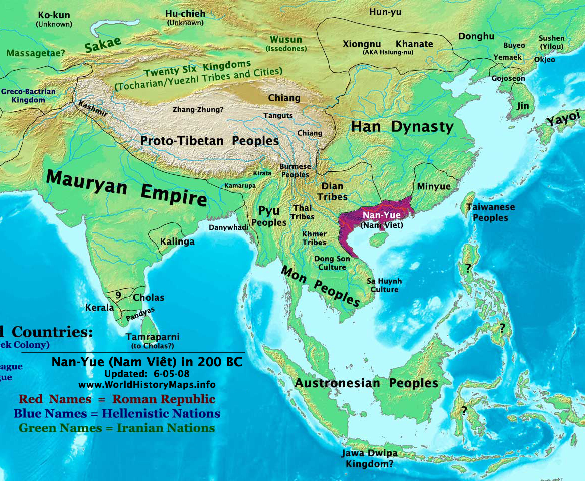
English: Map of ancient Nam Việt (204 BCE - 111 BCE) - an ancient kingdom that consisted of parts of the modern southern Chinese provinces of Guangdong, Guangxi, Yunnan and northern Vietnam.
|
| วันที่ | 10 กรกฎาคม พ.ศ. 2552 (original upload date) |
| แหล่งที่มา | นำเข้าจาก en.wikipedia มายังคอมมอนส์ โดย Alagos |
| ผู้สร้างสรรค์ | The original uploader was Sea888 ที่ วิกิพีเดียภาษาอังกฤษ. |
การอนุญาตใช้สิทธิ
ไฟล์นี้อยู่ภายใต้สัญญาอนุญาต ครีเอทีฟคอมมอนส์ แบบแสดงที่มา-อนุญาตแบบเดียวกัน 3.0 ต้นฉบับ
- คุณสามารถ:
- ที่จะแบ่งปัน – ที่จะทำสำเนา แจกจ่าย และส่งงานดังกล่าวต่อไป
- ที่จะเรียบเรียงใหม่ – ที่จะดัดแปลงงานดังกล่าว
- ภายใต้เงื่อนไขต่อไปนี้:
- แสดงที่มา – คุณต้องให้เกียรติเจ้าของงานอย่างเหมาะสม โดยเพิ่มลิงก์ไปยังสัญญาอนุญาต และระบุหากมีการเปลี่ยนแปลง คุณอาจทำเช่นนี้ได้ในรูปแบบใดก็ได้ตามควร แต่ต้องไม่ใช่ในลักษณะที่แนะว่าผู้ให้อนุญาตสนับสนุนคุณหรือการใช้งานของคุณ
- อนุญาตแบบเดียวกัน – หากคุณดัดแปลง เปลี่ยนรูป หรือต่อเติมงานนี้ คุณต้องใช้สัญญาอนุญาตแบบเดียวกันหรือแบบที่เหมือนกับสัญญาอนุญาตที่ใช้กับงานนี้เท่านั้น
บันทึกการอัพโหลด
The original description page was here. All following user names refer to en.wikipedia.
Upload date | User | Bytes | Dimensions | Comment
- 2009-07-10 19:33:35 | Sea888 | 876342 | 1166×960 | Author: Thomas A. Lessman. Source URL: http://www.worldhistorymaps.info/maps.html. Image was created by me (Thomas Lessman) based on map of Eastern Hemisphere in 200 BC. Image is free for public and/or educational use. I would appreciate a mention if this
ประวัติไฟล์
คลิกวันที่/เวลาเพื่อดูไฟล์ที่ปรากฏในขณะนั้น
| วันที่/เวลา | รูปย่อ | ขนาด | ผู้ใช้ | ความเห็น | |
|---|---|---|---|---|---|
| ปัจจุบัน | 22:27, 5 มกราคม 2556 | | 1,166 × 960 (856 กิโลไบต์) | Alagos | {{CH2MoveToCommons|en.wikipedia|year={{subst:CURRENTYEAR}}|month={{subst:CURRENTMONTHNAME}}|day={{subst:CURRENTDAY}}}} The tool and the bot are operated by User:Jan Luca and User:Magnus Manske. =={{int:filedesc}}== {{Information |description=A... |
หน้าที่มีภาพนี้
หน้าต่อไปนี้ โยงมาที่ภาพนี้:
การใช้ไฟล์ข้ามโครงการ
วิกิอื่นต่อไปนี้ใช้ไฟล์นี้:
- การใช้บน ast.wikipedia.org
- การใช้บน bcl.wikipedia.org
- การใช้บน bn.wikipedia.org
- การใช้บน en.wikipedia.org
- การใช้บน es.wikipedia.org
- การใช้บน eu.wikipedia.org
- การใช้บน fi.wikipedia.org
- การใช้บน fr.wikipedia.org
- การใช้บน id.wikipedia.org
- การใช้บน ja.wikipedia.org
- การใช้บน pnb.wikipedia.org
- การใช้บน pt.wikipedia.org
- การใช้บน ru.wikipedia.org
- การใช้บน uk.wikipedia.org
- การใช้บน ur.wikipedia.org
- การใช้บน vi.wikipedia.org